(Forecast)
Sunday (High 90, Low 61): Partly cloudy and hot. Isolated thunderstorms with potential for strong wind gusts are possible.
Monday (High 88, Low 63): Partly cloudy. Isolated showers and thunderstorms are possible.
Tuesday (High 86, Low 66): Partly cloudy. Widely scattered showers and thunderstorms are possible.
(Extended Outlook)
Wednesday (High 87, Low 65): Partly to mostly sunny with a 20% chance of a shower or thunderstorm.
Thursday (High 84, Low 60): Sunny.
Friday (High 85, Low 59): Sunny.
Saturday (High 87, Low 61): Mostly sunny.
(Beach Forecast)
Sunday (High 85, Low 71): Partly cloudy with widely scattered showers and thunderstorms possible.
Monday (High 83, Low 69): Partly cloudy with scattered showers and thunderstorms possible.
Tuesday (High 84, Low 70): Partly cloudy with widely scattered showers and thunderstorms possible.
(Notes)
The National Weather Service has issued guidelines for staying safe from heat and other things this summer, and guidelines specifically related to hurricanes.
The National Weather Service is also taking a survey to see how to best simplify their messaging in their alerts.
(Discussion)
At 4 PM, latest observation available shows mostly sunny skies in Cullman, temperature of 88 degrees, which looks to be our High for the day. Dewpoint is 55 degrees, making the relative humidity 33%. Interestingly this makes the Heat Index only 86 degrees, one of the rare times I've noticed a summer temperature higher than the Heat Index when things are warming up like they are in this pattern. Pressure is 29.86 and falling. Winds are variable at 6 miles per hour. Our Low this morning was 59. Haleyville has been mostly sunny today, though a good bit of fog this morning, looks like High will be 87 there for today, Low this morning also 59 like Cullman. Jasper has had almost no cloud cover today and got up to 90 degrees this afternoon, after a morning Low of 59. Seems to be a popular number for morning Lows today. But I'm not going to note the observations for a wide area since this blog seems to have a localized readership so far. And it takes extra time.


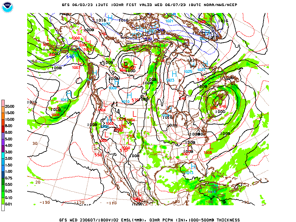
We are in that typical summer standoff pattern between High pressure, currently centered over the Plains and the Ark-LA-Tex region, and moisture from the Gulf of Mexico.
The GFS is not showing a ton of moisture available on this run for tomorrow afternoon.
The NAM is showing a little more.
And even though these are expected to be scattered showers and storms in nature, anything we get tomorrow, the Storm Prediction Center has outlooked a 5% marginal risk for damaging wind gusts. I hesitate to include such outlooks this time of year, since really any random "pulse" storms in summer can briefly reach severe limits with strong winds like that, or some hail. Our severe weather season is definitely over, and this is typical for early summer.
I'm really not impressed with model guidance lately, and taking into account the overall pattern over the past several days, I'm only introducing a 20% chance of thunderstorms for tomorrow. We may even see may more sun than we do clouds. High should be near 90 degrees, morning Low about 61.
Subtle changes to the weather maps Monday, but not much change to the overall pattern. Think will keep rain chance at 20%, just isolated rain and/or storms, High of about 88-89 and Low about 62-63. Even for tomorrow, Sunday, maybe I'm overshooting by forecasting 90. Maybe I should go with 89. But Jasper did see 90 today. And even if we get a few scattered strong storms tomorrow, things may cook up before we do. Meteorologists care about getting these nitpicky details, but in this pattern, I doubt the average person will notice much difference one day to the next.
Even on Tuesday, when a weak cold front is forecast to park along the Alabama/Tennessee state line, it doesn't look like it will bring any sort of drastic increase in rain chances, much less a big temperature change.
The GFS makes our rain chances look puny considering we've got a cold front nearby. The NAM looks a little better, but I'm not showing it, that's 78 hours out, when a mesoscale model starts to be less reliable. But I do agree with the NAM idea anyway, just based on my experience of how the weather behaves around here. That weak front will probably increase our rain chances only slightly. I'll bring the rain chance up to 30% instead of 20%. I don't think the models are interpreting this well, now or several days ago when they were trying to really ramp up the moisture for Tuesday. I think the reality is in between. High should be about 85-87 and the Low about 64-66 range.
Then as we get into Wednesday, we'll have isolated showers and thunderstorms rotating around the Low pressure system parked to our Northeast. But overall more sun than clouds. High in upper 80's, Low going back more into lower 60's with less moisture available, but keeping a 20% chance of rain in there.


And actually we may get a weak frontal passage in the extended period. That's what I'm going to base the forecast on. It is still early June. It looks reasonable to take out rain chances by Friday but probably as early as Thursday.
So to recap the overall pattern: Tomorrow looks like only isolated thunderstorms, but could pulse up and produce strong (or even severe) winds where they do happen, can damage trees and power lines sometimes, those summer storms. High about 89-90, Low about 60-61. Then Monday, keep the 20% chance of rain in there, High about 88-89, Low about 62-63. Then Tuesday as the front gets to the state line, rain chance comes up to 30% which is still widely scattered showers or storms. High temperature should be more like 85-87 range, Low 64-66 range. Then I'm rethinking Wednesday because of this front. But I think I'll bring the rain chance back to 20% since this is weak but does look like it will move into South Alabama over the latter part of this coming week. Edge the High back up to about 86-88 range, Low still in mid-60's. And then for Thursday, I think drier air will take over, especially with the High pressure settling over the Great Lakes/Midwest region. Will forecast sunny skies for Thursday and Friday, High on both days should drop to mid-80's with the Low around 60. And then on Saturday, may warm up a degree or two, but will only mention a slight increase in cloud cover, not bringing rain chances back.


Getting into the territory of reading tea leaves, the GFS wants to bring a front in here next Sunday with rain chances suddenly increasing. Not sure I buy it.
But since that pattern does persist into Monday, maybe I should pay attention.
The ECMWF is also showing that general trend of things getting wet as we go into week after this coming one. But this is so far out that you can't take it too seriously. Besides, if we do get a frontal passage this time of year, like it looks like we will this week, it usually is not a big rainmaker like this would suggest. These computer models don't live here and watch the weather locally year after year . . .
Then on Tuesday the moisture levels look like they will come down.
Probably not going to actually make a 10-Day Forecast above. I think it's still dicey to try to tell people the weather that far in advance. Especially since the models are showing a different scenario than we'd expect with local climatology. I'll show my readers more respect than that.
And Tropical Cyclone Arlene is basically dissipated North of the Western coast of Cuba. I still think these things look lovely from outer space.

And people in the path of the remnants may still have some heavy rains, maybe some gusty winds. Notice the rainfall totals for Miami may be on the heavy side. Up around here, average rainfall is about what you'd expect in the summer.


No comments:
Post a Comment