Details soon - does include Cullman County.
2:36 - I don't know why this is, but the Storm Prediction Center site is not showing this latest watch yet. It is on Twitter, while Daryl Herzmann's IEM accounts are not anymore. I'm seeing if I can use his direct website to keep up with stuff in a less convenient way. We take things and folks who set them up for granted sometimes, and he really has done the meteorological community a great service by maintaining that. And he kept it on social media as long as some goofball didn't foul it up. Who would have thought the inventor of Tesla cars could wreak havoc in the world of meteorology, just because he had his head too far up his own keister? I say stuff like that because I'm not popular and beloved to begin with. I have a total of four followers on social media. And all sarcasm aside, I do appreciate each of them.

Anyway to get to the important part, we've got scattered showers and thunderstorms forming in the heat and humidity as this cold front sags southward. It is actually expected to move through the region, even though this is July, been a sort of weird summer, and some of the storms may reach severe limits today and tonight around here. The really organized storms that are producing damaging winds right now are back in Southwest Tennessee and Northern Mississippi. But we have other activity forming ahead of it. So this watch is just to let everyone in North Alabama and Southern Middle Tennessee know that through about 9 PM tonight, there is a risk for some of these thunderstorms producing strong winds that could do damage, perhaps even reaching hurricane force in some cases. And we could also have some large hail, unfortunately could also be more significant than usual, they are estimating that golfball size will be possible.
So if you live in a mobile home, you might consider spending this evening with a friend who has a sturdier house, especially if you've got trees around. Try not to get caught driving through any severe thunderstorms. We already had some flooding in Huntsville and Harvest earlier this morning, talk about rough driving conditions. So don't cross any water covering the road, of course.
But seriously, it would be wise to pay attention if you get a Severe Thunderstorm Warning this afternoon or evening. At least stay inside, away from windows, away from anything electrical. But if you really want to be safe, I'd get into something like a hallway on the lowest floor. And as I say, it's better if you can be in a site-built home anchored to the ground, rather than a mobile home. You don't have to go full tornado-level shelter today necessarily, but since we do have some risk of at least isolated instances of winds that could get up to hurricane force, combined with a risk of hail that could get to golfball size, I'm not going to discourage anyone who wants to play it safe and take any extra precautions. That's probably the smart thing to do. I'm just saying for average people, this doesn't have to be a total drag where it shoots the whole day.
Will probably post radar updates here roughly every hour depending on how things trend.
3:13 PM - Well the Storm Prediction Center still hasn't posted the actual text of this watch, so I'm giving up on that and just going to post radar updates or warnings as needed.
The severe thunderstorms with a history of producing wind damage (hail is actually under severe limits for now in these storms) are getting ready to move into Wayne County, Tennessee within the next 30 minutes. Already producing damaging winds in McNairy County just West of there. And we've got issues in Northern Mississippi as well. Those storms should maintain strength as they move into Alabama over about the next hour. Given the time of day, they may even intensify somewhat.
3:19 - Saw on Twitter that the North Carolina tornado from a day or two ago was rated an F-3, the first time that's ever happened there in July. That storm made history, injured 16 people, and two of those injuries were life-threatening. When it gets to that level of wind, that's when you really start to need a basement if you can get to one, or a storm shelter. Because with the poor construction practices we've got in even very tornado-prone places (like here), sometimes, a tornado that strong can blow the whole house up. It does not take a rare F-5, or E/F-5. But you don't really expect that in July anyway. Crazy weather this summer.
3:25 - People in places like Muscle Shoals or Hamilton also want to be monitoring these storms in Mississippi and getting ready to get to a safe-enough place before they move in.
The storms in Alabama as of right now are staying under severe limits, the only thing to watch is the lightning, stay inside if you can hear thunder, common sense.
3:33 - And you know what . . . we've got Rock the South going on in Cullman. Some people may be travelling to it as we speak. So here is a look at the storms moving through the county. These are not severe at this point, but they are still producing a good bit of rain and a good bit of lightning. So people need to be cautious about that.
3:37 - A Severe Thunderstorm Warning has come out for Wayne County, Tennessee.
Estimating 60 mph wind gusts and quarter sized hail with these storms. So far we're not seeing those extra-damaging winds or hail, but from past experience this very summer, we know things can escalate quickly. Any of the warnings are worth paying attention to and at least staying inside, away from windows.
3:43 - I had totally forgotten about that Rock the South festival until I heard some noise last night that sounded like a concert in town. The timing is unfortunate for these storms, but you know, sometimes it happens.
Tomorrow night looks great. I think Jo Dee Messina and Chris Stapleton are the headliners then.
3:49 - I'd have already gotten back in my car if I was down there.
Or maybe they have a place people can get inside. Though I kind of doubt that on a farm . . . really wide open land. I only saw the show one year when they were still at the park.
3:54 - Okay now a severe thunderstorm warning for Southern Colbert, Franklin, and Western Lawrence Counties for potential of 60 mile per hour wind gusts, maybe a little hail but not severe hail.
This includes communities like Russellville, Red Bay, over to Phil Campbell, and clips places like Town Creek and Moulton. Anywhere within that polygon, I'd get to a good safe place and stay there until the storms pass.
3:57 - And we actually do have a Special Weather Statement for the storms moving through Cullman right now. These winds are just under severe limits and may affect other places like Eva, Arab, Guntersville, down to Albertville or even Boaz.
4:01 PM - And here is the broad view. Not all of these storms are becoming severe. The lightning sure is fierce in some of the sub-severe ones though, especially where a music festival is going on unfortunately.
4:03 - If there is a silver lining for Cullman, it is that with this much rain-cooled air, and then the dark hours falling, plus the atmosphere kind of worked over by all the lightning, the risk of any storms becoming severe later tonight may be lessened quite a bit. Never say never, but hopefully this is the worst the concertgoers will have to deal with.
Though there will likely be more rain at least, if not more storms later. Since we didn't get a hailstorm out of this, yeah, those other storms will probably produce a decent amount of lightning later. I'm just thinking the rain-cooling right now could help them out from any problems with severe level winds later, which really would be more of a problem to deal with at a big outdoor concert like that. With lightning they can just send people inside somewhere, even back to their cars. They did that in the park one year.
And like James Spann shared on the tweeter, it looks like they are being smart and doing a weather delay. Maybe people were mostly traveling to the event and not out in the open concert grounds yet. I really have not kept up with the schedule, had a rough month, where going to a concert never crossed my mind as a remote possibility. I did hear Alabama from a distance last year, and they were incredible.
4:14 - And now a Flash Flood Warning has been issued for most of Cullman County. This really is a dangerous situation for anyone driving to that concert, more than with a strong storm. If you know anybody going there, please remind them not to try to cross any flooded roadways. The concert organizers will have to deal with this the best they can. Just . . . safety first with this one.
But really all the way down to Hanceville, Colony, and Bremen, this is a serious threat. And up to Vinemont, Holly Pond, and Baileyton. It is not limited to the city of Cullman where the concert is going on.
4:31 - And it looks like that is what this event is turning into for the moment, besides that one storm near Amory, Mississippi that is showing signs of severe winds and maybe marginally severe hail. All the other warnings are gone except that flash flood warning in the place that needs it the least, Cullman County. Or I guess Huntsville/Madison County would be a tie, since they had flooding already this morning. But still, you don't want to see flooding issues and a lot of lightning when people are driving to or from a big outdoor concert. Looks like the organizers have been paying attention to the weather and being really smart about it, from what I saw so far.
.gif)
4:35 - Ok now as these storms are moving into Blount County, they are showing signs of becoming severe. Either they've strengthened, or the Birmingham office thought they looked more threatening than the Huntsville office did. But this affects places like Snead, down to Oneonta, actually all the way down to places like Warrior and Morris in Northern Jefferson County, a Severe Thunderstorm Warning.
Still got the Flash Flood Warning for Cullman County. And that is a dangerous situation when you've got people trying to drive to a concert, definitely need to be careful.
4:39 - And actually after a second look, that Severe T-Storm Warning does clip Etowah and St. Clair Counties too.
Severe T-Storm Watch still in effect areawide until 9 PM.
Taking the wide view, plenty of storms still in Tennessee. Directions of these storms can change sometimes, and if some move more Southeast or Southward, then folks in Alabama will of course get them downstream. And the trend right now is for these storms to drift Southeast at about 20-30 mph.
4:45 - Looking at the wide view, putting the radar into motion, looks like the Rock the South festival in Cullman will likely deal with more rain after this batch of thunderstorms it's already dealt with. How much thunder and lightning, not sure, but the temperature has dropped down to 73, same dewpoint, so the risk of any severe thunderstorms is low after this batch of storms really worked the atmosphere over. Looks like the threats for concertgoers are mainly the flash flooding that is likely to be a hazard countywide, and maybe some more lightning with the other showers/thunderstorms behind this batch.
4:54 - So I notice now that some of those storms entering Northeast Alabama from Tennessee, those are storms doing what I was suspecting might happen, starting to move more due South, even while other storms continue with more of a West to East, or Northwest to Southeast motion.
And here is the weather radio going off again for something.
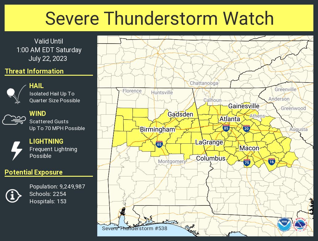
Ok this is just a new Severe Thunderstorm Watch that covers Central Alabama, counties like Walker, Winston, and so on, goes until Midnight. Basically an extension of this watch further North.
Those storms moving southward from Tennessee into mainly Northeast Alabama are strong thunderstorms, but for now, they have remained below severe limits. To be severe, a thunderstorm has to show signs of producing winds of at least 50 knots (58 mph) or hail an inch in diameter (quarter sized). That's when a thunderstorm is thought to become a significant threat to life and property.
5 PM - Here is the graphic for that new Severe Thunderstorm Watch. But please note that the earlier Severe Thunderstorm Watch remains in effect for Northern Alabama and Southern Middle Tennessee until 9 PM. But the threat has spread into Central Alabama now, enough to require a new watch, sort of like extending the area and updating the time stamp - new watch goes until Midnight.
And I notice they are not expecting really large hail now, seeing how the storms performed earlier, but still, quarter-sized hail is considered severe. And the winds gusts will probably be more in the 60-70 mile per hour range after all. So today could have been a lot worse.
Though I do feel for the folks in Huntsville and other parts of Madison County who dealt with flooding issues this morning and the people trying to get to that concert with all this mess going on where the heaviest rain and lightning really zeroed in on Cullman and Cullman County there for a while. They definitely won't be complaining that the forecast mentioning possibility of strong storms was a bust . . . have heard of no injuries so far, so can always count that as a silver lining for the time being.
5:06 - Doesn't look like the folks at the farm are letting the weather bother them a bit.
I was just thinking of it from a big picture, public safety standpoint, especially from the flooding. But it looks like on the actual concert grounds, people just see a chance to play in the mud.
5:13 - Okay, now we have a new Flash Flood Warning, for Limestone and Madison Counties, mainly from places like Athens and Elkmont over to Harvest and the Northern part of the city of Huntsville, on up to the Tennessee state line there in Madison County. And these folks do not need it. The flooding could become very dangerous there - okay? There's that potential, I feel I should go ahead and mention. They already had flooding this morning. And this is just not a great situation. Please encourage anyone you know in these areas to play it safe, and if possible, stay off the roads. It's easier to flood urban areas than out in the country, and this does include at least the North part of Huntsville. So this could be serious business for some people.

5:21 - And I'm going to pass along this Special Weather Statement too, which is for Southern Madison County, also includes city of Huntsville, extends into Southern Jackson and Northern Marshall Counties. They are expecting wind gusts up to 55 miles per hour with this, and that is just riding the line of what is considered severe winds. If it gusts to 58, it's considered severe. So I'm passing this along anyway even though it is not a Warning, and there is no outdoor concert up that way. It still strikes me as a dangerous situation, because trees can still be damaged or even uprooted by those winds sometimes. It is a close enough call. And with flash flooding already having been an issue earlier today in this same general area, it will be a lot easier for some trees to come down. And the rain will be heavy with these storms, actually prompted that new Flood Warning I just passed on that is for the Northern part of town, Huntsville.
So anywhere in Huntsville, you've got some rough stuff moving through right about now.
5:25 - And it looks like somebody had an afterthought, went ahead and upgraded it to a Severe Thunderstorm Warning.
Sometimes it really is a close call, and good forecasters do not like to overwarn, but they also want to make sure if there's a significant danger, they don't miss it. Always trying to strike that balance. And I definitely agree with the call to upgrade this one.

5:30 - Panning out for the bigger picture again, our main areas of concern are: Cullman County with flooding issues (with an outdoor concert going on, that draws a big crowd every year, please advise your loved ones to be careful about this, or of course if you are going yourself, use good sense, have at least one sober person . . . which you should really have anyway, but especially when it's flooding), Limeston and Madison County with flooding issues that include the city of Huntsville - and also potential for damaging winds that includes Huntsville and points South in Madison County, stretching into Southern Jackson and Northern Marshall Counties. And then sort of out of our area, more into Central Alabama, they also have damaging wind potential with severe thunderstorms down around places like Talladega and Anniston, Jacksonville, Gadsden may still be dealing with the storms moving out of there down toward these other areas.
And we are all under a Severe Thunderstorm Watch until 9 PM - unless you are more into Central Alabama, and the watch goes until Midnight for you.
This has been an active afternoon and evening around here. We could have further issues, at least with flooding, maybe with some damaging winds too, even in places that have already seen rain and storms. The flooding threat is the more likely, but don't get complacent about the damaging wind threat, especially if your home is surrounded by trees. With all this rainfall in the soil, it won't take as much for trees to come down.
At least stay inside and away from windows. But if you can be in a site-built home rather than a mobile home, then if you are under a Severe Thunderstorm Warning this evening, you might consider moving to the lowest floor and sort of move toward a smaller space like a hallway, so that on the chance a tree were to fall, or something were to break a window, you would have a much better chance of coming out of it without any injury.

5:37 - Okay, the National Weather Service in Huntsville is pushing the severity of this storm in Southern Madison County and noting that in addition to the damaging winds, there is enough rotation showing up on radar that a tornado could develop as well. And remember we did have a tornado in Monrovia the other day, during this wacky wild summer. So I would advise getting to a small central room (like a bathroom, closet or hallway) on the lowest floor of your home, well away from any windows, just to be on the safe side. If you have time to get out of a mobile home and over to a friend's sturdier house, then I would do that before these storms get to you.
5:41 - Taking the broad view again. And the weather radio is going off again . . . hmmmmmmm . . . but . . . ok Severe Thunderstorm Warning for Southeast Walker County, also affects parts of Tuscaloosa and Jefferson Counties.
Anyway before we get to that new one, will note that the rotation in these storms moving into Jackson County now is awfully broad compared to what you'd look for with a tornado usually. But it is some fierce winds either way. And I'd advise anyone reading to take the best precautions that are reasonably within your means. Get as low in your home as you can and as near the center. And if you have time to get out of a mobile home and into a friend's sturdier house, that is probably a good idea. Don't get in a panic over this and drive through any flooded roads though, or where the wind would blow you all over the road. Just take a deep breath and do the most sensible thing that is within your means in your current situation, and you should be fine.
Even when we had that tornado in Monrovia recently, nobody got hurt. So it's nothing to get too freaked out over, but just use good sense and take what precautions you can. I know this situation is kind of difficult with a lot of hazards going on in some of the same counties all at one time. It is a lot to keep up with. But just take sensible precautions until the storms pass.
5:48 - And here we finally see that wide view again. The only severe thunderstorm warning left in North Alabama is that part of the storms moving out of Southern Madison County into Jackson County. Flash Flood Warnings remain in effect for Cullman, Limestone, and Madison Counties. This does include Athens, Northern Huntsville, and the city of Cullman. Actually in Cullman it is basically the whole county at risk for flooding issues.
5:52 - That warning that includes Walker County only includes the far Southern part. I did notice Gorgas Steam Plant was mentioned in the text of the warning.
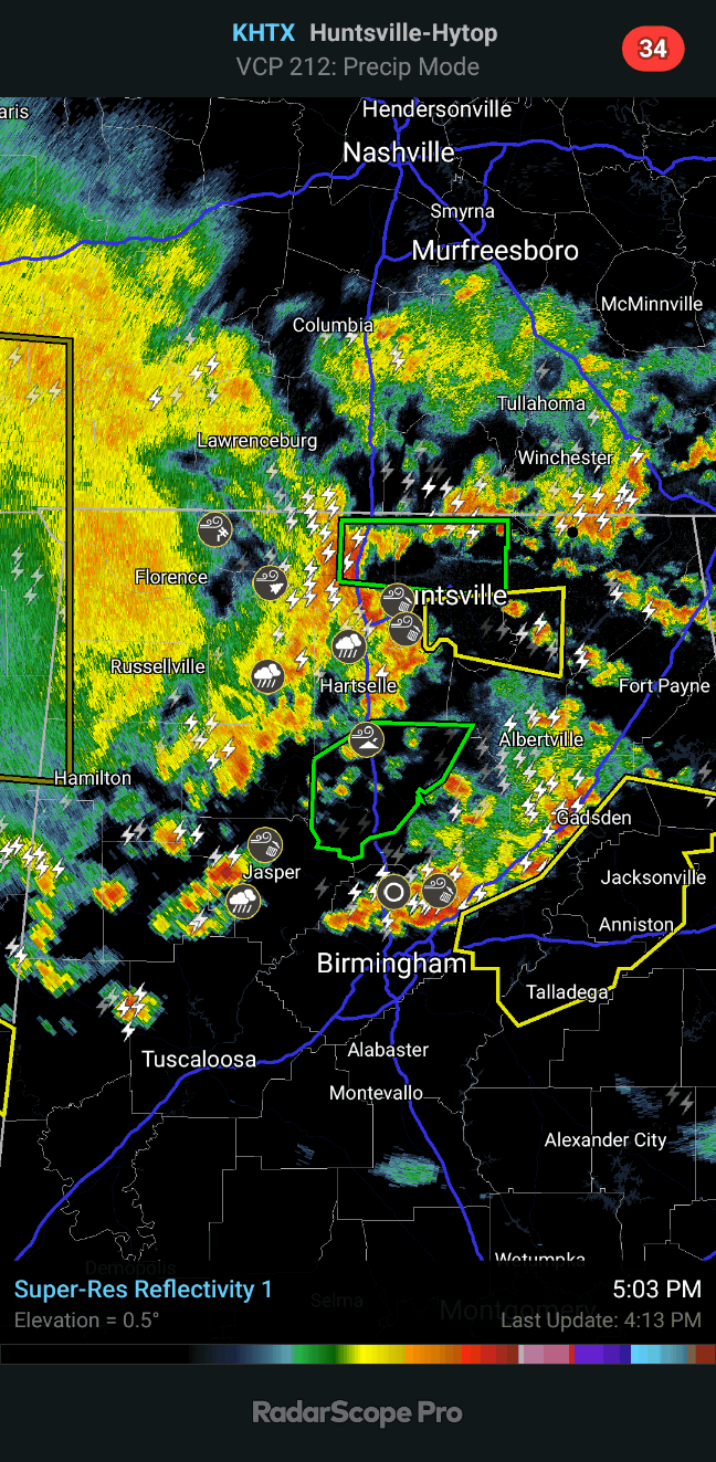
5:54 - Here is a better visual aid to what we've got going on. It's been a busy evening.
The flood warnings are green on Radarscope, a sort of maroon color on the NWS graphics like the one above. Of course the orange or yellow are the severe thunderstorm warnings.
5:58 - That warning that includes Scottsboro goes for about another 30 minutes, until 6:30 PM CDT.
Anywhere within that polygon, in or near those communities you see on the map above, I'd stay in a safe place until the storms pass and/or the warning expires. Winds could gust to 60 or even 70 mph here. At least stay inside and away from windows, also want to avoid anything electrical. When a lot of lightning was coming through my area earlier, even though the storms were not severe at that point, I ran my laptop and phone on battery power. To be on the safe side. When things get rowdy on days like this, I'd rather not fool around.
6:05 PM - Looks like a gas station in Athens got damaged, with power out.
6:07 - Still some rotation showing up at times with the storm now moving through Scottsboro. It is weak rotation, but still, please respect the potential for damaging winds that can at least knock down trees this evening. If in the path, stay in a safe shelter, the best you've got at hand.
6:11 - Gadsden appears to have had some minor structural damage from the storms earlier. Crazy evening. I hope my forecast last night gave people some idea that this was coming. If so I didn't believe my own words enough, because I really did not expect it to get this organized for so many different spots on the map, at least not this early in the day, expected the more organized rain and storms to come in at night, or at least right about now. But some of it started in the early to mid afternoon instead.
6:13 - This event is winding down overall though. The Severe Thunderstorm Watch has been cancelled for Wayne, Lawrence, and Giles Counties in Tennessee; remains in effect for Lincoln, Moore, and Franklin there. On the Alabama side, Lauderdale, Colbert Franklin, Lawrence, Winston, Marion, and Lamar Counties have been cleared from the Watch. It continues in Alabama for all other counties in North and Central Alabama.
And they are finally letting that Rock the South concert start at 6:30. That information is from WAFF-48 in Huntsville.
6:20 - As the storms move into Dekalb County, affecting places like Rainsville and Fort Payne, they are expected to have strong winds and maybe small hail, but under severe limits now.
6:22 - No more severe thunderstorm warnings in North Alabama or up into Tennessee now, all that activity is now along and South of Birmingham.
We do have flash flood warnings still in effect for Cullman County and for Limestone and Madison Counties. This does include the city of Cullman and basically the whole county there. And it includes Athens and the Northern part of Huntsville, on up to the Tennessee state line.
6:49 - They replaced the Flash Flood Warning for Cullman County with a Flood Warning more concerned with rivers and other bodies of water remaining affected the flood waters earlier. So I posted that separately.
6:51 - Overall this event has wound down for North Alabama and certainly for Tennessee. I think they are keeping the Watch in effect in case of any last minute surprises before the storms finish exiting the state. I've seen that happen a lot, where people were complaining why the watch was not cancelled, and then one rogue storm would really fire up just when we were ready to call it a day.
6:54 - And the Watch is cancelled for North Alabama and any remaining Tennessee counties.
So coverage is over.
7:42 PM - Spoke too soon about no injuries. Saw where one person was injured today when a tree fell on a car near Memphis. Also saw a video of a woman who got debris from a church roof in Gadsden blown at her car's windshield. That's why all people involved in weather, not just this blogger here, encourage people not to get caught in a vehicle during even a minor round of severe weather, if you can do anything about it.
Posted a forecast. Weather looks great tomorrow, after a little rain might hang around in the morning, through most of next week, maybe all of next week. Even when the temperatures climb back into 90's toward the weekend, the humidity is still going to be lower than it's been lately. It doesn't get much better than this for late July, put it that way.
7:47 - One more note: I was feeling pretty good about this blog today, since I got more views in one day than I usually do in a month. I figured people were checking on the Rock the South concert. But unfortunately when I went looking at stats in more detail, that big spike in visits to the site appeared to all have come from Israel. How anybody over there found this blog, I have no idea. I'm almost hoping that was somebody with a VPN who decided to read my stuff obsessively, because I don't want to attract the attention of some nut who took something I said out of context. Hear ye, hear ye . . . I don't do the weather for Israel. And even my most opinionated posts are meant to be taken with a sense of humor. God bless ya'.


.gif)


.jpeg)


.png)
.png)


.png)


No comments:
Post a Comment