

(Forecast)
Today (High 96, Low 72): Mostly sunny. Very hot and humid.
Friday (High 95, Low 73): Mostly sunny. Very hot and humid.
Saturday (High 95, Low 73): Mostly sunny. Very hot and humid.
Sunday (High 93, Low 72): Partly to mostly sunny. An isolated shower or thunderstorm is possible.
(Extended Outlook)
Monday (High 89, Low 70): Partly cloudy with a 20% chance of showers/thunderstorms.
Tuesday (High 86, Low 69): Partly cloudy with a 20% chance of showers/thunderstorms.
Wednesday (High 85, Low 65): Mostly sunny.
Thursday (High 87, Low 64): Mostly sunny.
(Tea Leaves Territory)
Friday September 1st (High 89, Low 66): Partly cloudy with a 20% chance of showers/thunderstorms.
Saturday September 2nd (High 90, Low 69): Partly cloudy with a 20% chance of showers/thunderstorms.
Sunday September 3rd (High 89, Low 70): Partly cloudy with a 30% chance of showers/thunderstorms.
Labor Day (High 88, Low 70): Partly cloudy with a 30% chance of showers/thunderstorms.
(Beach Forecast)
Today (High 95, Low 79): Sunny and hot.
Friday (High 95, Low 76): Sunny.
Saturday (High 98, Low 77): Mostly sunny with an isolated shower or thunderstorm possible.
Sunday (High 99, Low 79): Mostly sunny with an isolated shower or thunderstorm possible.
Next week (Highs in mid-90's, Lows in upper-70's): Partly cloudy with a 40% chance of showers/thunderstorms.
(Pronóstico)
Hoy (Máxima 96, Mínima 72): Mayormente soleado. Mucho calor y humedad.
Viernes (Máxima 95, Mínima 73): Mayormente soleado. Mucho calor y humedad.
Sábado (Máxima 95, Mínima 73): Mayormente soleado. Mucho calor y humedad.
Domingo (Máxima 93, Mínima 72): Parcialmente a mayormente soleado. Es posible que se produzcan una lluvia o tormenta aislada.
(Perspectiva Extendida)
Lunes (Máxima 89, Mínima 70): Parcialmente nublado con un 20 % de probabilidad de lluvias/tormentas eléctricas.
Martes (Máxima 86, Mínima 69): Parcialmente nublado con un 20 % de probabilidad de lluvias/tormentas eléctricas.
Miércoles (Máxima 85, Mínima 65): Mayormente soleado.
Jueves (Máxima 87, Mínima 64): Mayormente soleado.
(Territorio de las Hojas de Té)
Viernes primero de septiembre (Máxima 89, Mínima 66): Parcialmente nublado con un 20 % de probabilidad de lluvias/tormentas eléctricas.
Sábado segundo de septiembre (Máxima 90, Mínima 69): Parcialmente nublado con un 20 % de probabilidad de lluvias/tormentas eléctricas.
Domingo tercero de septiembre (Máxima 89, Mínima 70): Parcialmente nublado con un 30% de probabilidad de lluvias/tormentas eléctricas.
Día Laboral (Máxima 88, Mínima 70): Parcialmente nublado con un 30 % de probabilidad de lluvias/tormentas eléctricas.
(Pronóstico de la Playa)
Hoy (Máxima 95, Mínima 79): Soleado y caluroso.
Viernes (Máxima 95, Mínima 76): Soleado.
Sábado (Máxima 98, Mínima 77): Mayormente soleado con posible lluvia o tormenta aislada.
Domingo (Máxima 99, Mínima 79): Mayormente soleado, con posibilidad de lluvias o tormentas eléctricas aisladas.
La próxima semana (Máximas a mediados de los 90, Mínimas en los 70 superiores): Parcialmente nublado con un 40 % de probabilidad de lluvias/tormentas eléctricas.
(Notes)
Here are some reminders about staying safe in rip currents at the beach.
We are under a Heat Advisory, and if you know of anybody who might leave their kids or even a pet in a hot car, please try to discourage that sort of thing while the heat really is dangerous, hottest it's been this year.
The National Weather Service offices that serve Tennessee (including Huntsville) have made preparedness pages available in English and Spanish. I'm toying around with Spanish forecasts sometimes, so if any native speakers see room for improvement, feel free to leave me a comment. And I'll fix anything that needs fixing. I used to be pretty sharp with the language, but it is a matter of use it or lose it. And I've lost a lot of it. As many burritos as I eat, I almost owe it to the culture to brush up on the language again.
(Discussion)


At 11:15 PM, due to some fog and mist in the area, visibility in Cullman is down to 5 miles. The temperature is 77 degrees, same dewpoint, making the relative humidity 100%. Winds are calm. Pressure is 30.06 inches and steady.
We had a High of 93 and Low of 72 today, but the Heat Index got up to 107 under sunny summer skies. The High in Jasper got up to 97, Heat Index got up to 113, after a morning Low of 72. Haleyville had a High of 95, Low of 72 - Heat Index topped out at 107 there.
Decatur had a High of 98, Low of 75. Huntsville had a High of 96 and Low of 75. Fort Payne got up to 95, Low of 70. Gadsden had a High of 95, Low of 73. Other side of the state, Muscle Shoals had a High of 97 after a morning Low of 75.
Up across the Tennessee state line, Winchester had a High of 95 and Low of 72. Fayetteville had a High of 93, Low of 73. There was a little more cloud cover throughout the day in Chattanooga, but they still got up to 95, Low of 78. Nashville got up to 98 after a Low of 77. Noticing some muggier air up on the Tennessee side, of course the big cities also get this urban heat island effect where the asphalt traps a lot of the heat overnight compared to smaller towns or places out in the country. Really see that in Memphis, High of 98, Low of 81. That's more like a stuffy day down at the beach.
And some of the other cities in the region, Birmingham had a High of 97, Low of 77. Atlanta actually had a decent amount of cloud cover today and only got up to 92 degrees, morning Low of 82. I think that's the only site I've noticed where the Heat Index did not break 100 for Wednesday. And it has just turned Thursday, stroke of Midnight, but all these observations of course are for Wednesday August 23rd. And Tupelo had a High of 96, Low of 76. Their heat index got up to 111.
When the heat gets this bad, heat exhaustion and heatstroke become very real concerns. So we've had heat advisories issued across the area.

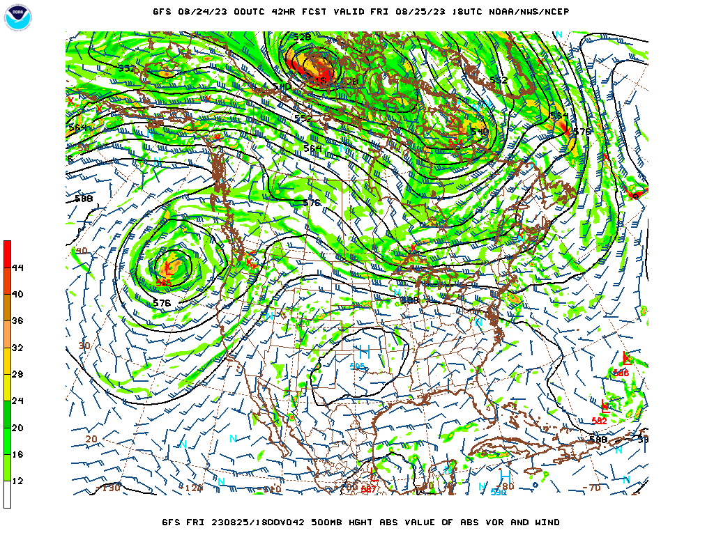
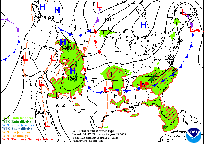
And that dome of high pressure is not going anywhere fast. We'll have to wait for a frontal boundary to change the pattern late this weekend. Other parts of the country are having some rain and thunderstorms, actually some heavy rain out in New Mexico, of all places, but a dying tropical system has been moving through there. And they recently had heavy rains in Las Vegas from another dying tropical system that hit Baja California and then moved inland. Showers and storms stretch from South Texas to Mobile down to places like Pensacola and Miami. Then a front is bringing some stronger storms to places like North Dakota, also Ohio and around the Great Lakes. Got some showers stretching up into parts of New England, like Pennsylvania and New York State. But it is dry and hot from most of the Mid-Atlantic, Carolinas, back through Alabama and Tennessee and actually into the Mid-South and Midwest, hottest week of the year is what it's been for many of us. And as I say, it has been a time when the heat has been dangerous by anybody's standards.


No comments:
Post a Comment