Tuesday (High 69, Low 45): Mostly cloudy and breezy with an isolated shower possible during the day. Then scattered showers are possible overnight.
Wednesday (High 57, Low 46): Overcast, cool, and breezy. Scattered showers are possible.
Thursday (High 63, Low 47): An isolated lingering shower is possible in the morning. Becoming mostly sunny the rest of the day.
Friday (High 64, Low 49): Overcast with a 30% chance of showers.
Saturday (High 63, Low 44): Mostly sunny.
Sunday (High 64, Low 35): Mostly sunny.
Monday (High 63, Low 45): Partly cloudy with a 20% chance of showers.
This is Winter Weather Awareness Week.
And we are in a drought emergency, burning things not allowed right now in Alabama.
We had mostly sunny skies overall in the Tennessee Valley today but with periods of clouds and even some light rain hanging around, light and variable winds. The High in Cullman was 68 with a Low this morning of 45. Jasper had a few more breezy periods today, but none of the rain, High of 72 and Low of 48 there. And Haleyville was also rain-free today with a High of 69 and Low of 45.
So the moisture hasn't gone away from this stationary front down in the Gulf of Mexico. Even though we have high pressure over the Carolinas. Those more southwesterly winds aloft have been pulling plenty of the moisture back up this way, though right now, it is mainly in the form of clouds than rain for North Alabama. The few spots of rain on radar are very light, and some of that may be virga, rain that evaporates before it even makes it to the ground. We did have a little light rain in Cullman at times today though, observed at Folsom Field.
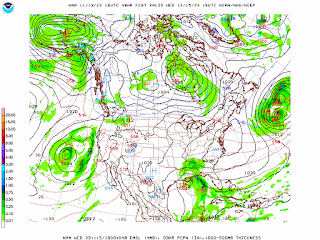
We've got a pretty good shortwave trough moving through Texas, and that should bring us our next chance of more organized rain tomorrow and tomorrow night.
Though it is starting to look like via the GFS above and also the guidance from the NAM and the ECMWF, moisture will be limited to South Alabama during the day tomorrow, at least enough for much rain. Still should see more clouds than periods of sunlight. It does look like a breezy day as that upper-level shortwave moves through and interacts with the Appalachian Mountains. High should be up near 70 but probably not quite making it, more like 68 or 69. Low tonight should be about 45.
The GFS has backed off on our rain chances Tuesday night into Wednesday. Keeping it further South.
The NAM has rain extended all the way up into Southern Tennessee at Noon on Wednesday.
Glanced at the European model, and its guidance is closer to the NAM look.
Will only introduce a 40% chance of rain here. High in upper 50's, Low in mid-40's. It does look breezy Tuesday, Tuesday night, into here Wednesday with a tight pressure gradient as this system interacts with the Appalachians.
Thursday we might see a stray shower lingering in the morning, but otherwise expecting mostly sunny skies, High rising into the lower 60's after a morning Low in the upper 40's.
Then Friday we have a reinforcing front coming in, should bump rain chances back up to at least 30%. Not comfortable raising them above that, since so many previous model runs have shown this front as being mostly a dry one on the southern end. Now they make it look like we will get some rain chances from it. But going to forecast on the conservative side. High should be in lower-to-mid-60's, Low near 50, probably a mostly overcast day.
Then that system is past us on Saturday and we have strong Northwest upper-level winds behind it. Skies should be mostly sunny, High in lower 60's, Low in lower-to-mid-40's.
Then on Sunday even as high pressure moves in here from the Plains, it does not look like a huge cooldown, just Highs in the lower 60's. Though Sunday morning will be a cold snap due to the sudden influx of dry air, allowing the Low to drop down to the mid-30's.
Then on Monday, a fairly organized system looks to be moving through the Plains. For now it looks like the rain may hold off until Tuesday for us, next Tuesday, so will only include a 20% chance of rain for Monday, High in lower 60's, the Low rebounding up into about the mid-40's as we do get some moisture in here, regardless of whether or not we see any rain for Monday.

Rainfall totals for us in the Northern part of Alabama and up into Tennessee should be about a quarter-inch or less. The bigger rains are going to stay in South Alabama and along other parts of the Gulf Coast. I like the way these minor rain events are chipping away at our drought, but we'll have to watch that system next week just to be on the safe side, since we've historically had a lot of severe weather in November. Nothing at this point makes it look concerning in that way though. Watching it out of caution, but it will probably just bring more rain that we desperately need around here at this point. And I had to bet, I wouldn't bank on it being a drought-buster either. Just something to watch since the system does look sort of organized.


No comments:
Post a Comment