Sunday (High 50): Rain ending by midday. Cloudy, breezy, and cold.
Monday (High 49, Low 25): Sunny. Cold, especially in the morning, when conditions will still be breezy.
Tuesday (High 54, Low 25): Sunny. Cold.
Wednesday (High 56, Low 30): Mostly sunny.
Thursday (High 58, Low 33): Mostly sunny.
Friday (High 59, Low 36): Partly cloudy with a 20% chance of showers.
Saturday (High 60, Low 39): Partly cloudy with a 20% chance of showers.
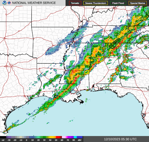
It was a sobering weather day in the Tennessee Valley. While the problems immediately in North Alabama and Southern Middle Tennessee were relatively minor ones, our neighbors North of downtown Nashville dealt with at least a couple of tornadoes that apparently did significant damage, and claimed some lives. One of the broadcast ladies in Nashville, afraid I'll get her name wrong, posted on social media that it had been a tough day for her because one of the victims of the storms was a toddler. So we dealt with some serious business today.

I saw where Davis Nolan speculated that there were three tornado tracks from those supercells up that way today. That looks plausible to me, but we'll let the survey teams do their thing and decide that. The Nashville office can tend to be a bit laid-back at times when it comes to advertising severe weather. One could never accuse them of being overly alarmist. So when they issued a Tornado Emergency today, everybody knew it meant serious business. I'm rather a fan of a lot of their staff these days and how they do the Weather101 classes. My respect for them tonight is through the tropopause.
In our neck of the woods, we only had a few trees down, and one power line also reported down. Many hail reports back in Mississippi.
Just for fun, the High in Cullman today was 70 with a morning Low of 57. I remember forecasting 69. It got even warmer, and man, we really lucked out around here. If the timing and placement of certain features had been just a little different, we could have had similar problems to what they had in Tennessee today. Once in a while you can kind of feel that you may have dodged a bullet. Today was one of those days for me. There was a time when it especially looked concerning along the AL/TN state line in the evening, supercells trying to get organized there. And all this happened with a positively tilted trough axis.
Things have calmed down now, and the Tornado Watch is cancelled. We do have a severe thunderstorm moving from Tuscaloosa into Jefferson County, and we've had some flooding issues in Northeast Alabama up into Tennessee as well. But overall we have lucked out for the night.
The cold front will be pushing the rest of the way through the area on Sunday. We won't have any more severe weather, just one of those really raw days where the temperature is going backwards. By the way, before you get impatient to know what F-rating (or EF-rating, to sound modern) any of these tornadoes have, please remember that these are real people who are going to be going out and doing surveys in the bitter cold, probably a lot of them doing it on little sleep. I'm glad they take their time and get it right.


So today, Sunday, will be a day of gradual clearing. Most of the rain should be over by about Noon, and we'll have a northerly breeze. Temperatures will top out at about 50 degrees, and then as the day goes on, that temperature will be dropping rapidly through the 40's and then 30's through the evening. So that combined with the wind is going to make for miserable cold after we just had an unusually warm day. Just a heads up since a lot of people are going to church or doing other activities. The weather is not turning suddenly nice, and clouds are likely to hang around today even after the rain ends. It's going to be a raw, cold sort of day.


By Monday morning we really will be in the core of the cold, dry air behind this strong front. We should be in the mid-20's at daybreak, and factoring in the breeze, our wind chill values may stay in the 20's through much of the morning. High should top out around 50 again. And the wind should die down in the afternoon. Plenty of sunshine, but another brutally cold day nonetheless.
Another day of abundant sunshine on Tuesday, and while the center of high pressure moves to the Mid-Atlantic coast, our air stays dry and cold enough that the High should only moderate to the mid-50's with a Low in the mid-20's again. By this time I think folks will have gotten used to the cold again, and we aren't expecting a wind that'll cut you in half. Winds should be light.
The pattern changes with this setup are going to be gradual this next week it looks like. Wednesday we'll only see the High rebounding to the upper 50's, and maybe just barely that, Low moderating back to about 30. Should see sunshine overall, maybe a few clouds returning.
Basically the same thing Thursday, upper 50's for the High, the Low making it into lower 30's.
And for Friday, the GFS has totally abandoned the idea of rain coming up from the Gulf. So will take even those minimal 20% rain probabilities out of tonight's forecast for Friday. The European model never was on board with that anyway, and it didn't look right when doing last night's analysis. The basic idea of some Gulf moisture is still there, but it's not as sudden and out of nowhere as it looked last night's runs. Might see an increase in clouds Friday, but still Highs in upper 50's, Lows in the 30's.
And I'm going to keep the forecast dry for Saturday too. High may edge toward 60 and Lows may climb into upper 30's, but I am not convinced yet that we'll see any rain for this forecast period. I guess I could cover myself by putting a 20% chance in for Friday and Saturday both, just in case, but I think we may get a dry weekend again for a change.
Wishing the best for the people affected by the storms today, or now I guess technically it is yesterday.
P.S. So I did finally decide on the lazy forecast mode and kept a 20% chance of rain in for both Friday and Saturday. If things trend drier, can always take the chance out later.


No comments:
Post a Comment