

Thursday (High 59, Low 30): Mostly sunny during the day. Becoming breezy at night with scattered rain possible.
Friday (High 64, Low 45): Windy and rainy. Isolated thunderstorms are possible, and a few could become severe.
Saturday (High 44, Low 24): Sunny. Cold and still somewhat breezy.
Sunday (High 49, Low 25): Mostly sunny.
M.L. King Day (High 33, Low 22): Cloudy with a 40% chance of showers - mostly in the form of a wintry mix of rain, sleet, freezing rain, and/or snow.
Tuesday (High 30, Low 9): Partly to mostly sunny with a 20% chance of snow showers.
And just to be on the safe side about any stronger storms Friday, here is a review of severe weather safety.


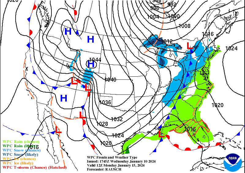
You can see both of our two storm systems lined up there, one in the Midwest, one still back largely over the Pacific Northwest, starting to approach the Rockies. One will affect us on Friday, then the next one on Monday.


Between these two systems, much of the country is going to see a good bit of snow in the near future. Right now the main focus for snow is in the Midwest/Great Lakes and also around the Rocky Mountains back into the Pacific Northwest.
Tomorrow looks mostly sunny, and since today's High was a little higher than what models were showing, I'm going to go above model guidance for tomorrow and forecast a High more like 58-59. The Low tonight should be 30-32 range. I will probably go with 30.
Then on Friday, that's when we have to keep an eye out for some low-end severe weather potential. The potential for thunderstorms becoming severe will likely stay more focused on Central and South Alabama, but North Alabama and up into Tennessee, still worth keeping an eye on it. I'm not worried about snow that night, Friday night. In Tennessee, there might be a few light accumulations mainly along the Cumberland Plateau. Even there, most people probably will not see more than a dusting.
Overall Friday should be rainy and windy with a High in the lower 60's, Low in the lower, maybe mid-40's. There will likely be enough instability for a few isolated thunderstorms up this way, but it is such a close call as to whether any of those will reach severe limits.


Even though our threat is definitely on the lower end, it would be wise to prepare. And that includes if you are driving, need to work out in your mind, three or four places along your route that you could pull over and get inside in case a tornado warning (or severe thunderstorm warning) was required.
The regular gradient winds are going to be howling though, with gusts up to 40-50 miles per hour possible again, like the other night, except this is more of a daytime event. Some of the winds could pick up Thursday night and some of the rain start before daylight on Friday. But it's going to be a rainy and windy day. And some people might lose their power even without any specific thunderstorms that can sustain and become severe.
And like I say, I'm really not worried about any wraparound snow showers Friday night. Even in Tennessee, I think the risk for any significant accumulation is very low, taking everything about this system into account.

Saturday behind the front, we will clear out quickly. Skies will be sunny, but talk about a shot of cold, dry air, we'll start the day in the mid-20's, maybe even lower 20's for some of us, and then warm to only about the lower 40's in the afternoon. And it will still be somewhat breezy, though not as windy as on Friday. So it will feel colder than those temperatures show.

Then Sunday our high pressure starts to shift to the East, and you can see that next storm system producing a lot of snow out West, some of it approaching Memphis by Sunday morning. Similar temperatures for the morning around here, but in the afternoon we'll see upper 40's, some places might make it to 50. Mostly sunny skies.
Then on Monday, without showing the model madness about timing and questions about type of precipitation, just know that the idea is on the table for some wintry precipitation as another cold front moves through Sunday night, on the back side of that front, expecting some rain to change over to sleet, maybe ice in some places, and for a lot of us, snow. I'm leaning toward a messy wintry mix that will include some freezing rain, especially in Northwest Alabama. How long that lasts, not sure, it may all change to snow at some point. More snow potential up on the Tennessee side, but North Alabama has a very decent chance at some accumulating snow and/or ice as well. Usually our accumulations are on the lighter side with this kind of a setup. But this is something to continue to monitor. The latest run of the ECMWF brings more precipitation up here from the Gulf of Mexico going into Tuesday. And all the model guidance has been a mess. Some more experienced forecasters than me have relied a lot on ensembles, which I only look at every now and then, don't have a lot of experience with. But sometimes even those, kind of like the spaghetti plots of hurricane tracks in the summer/fall, struggle to get the details right several days in advance like this. And it is more complicated because we have a storm system Friday to get out of the way. The models are trying to predict the atmosphere behind this first storm system, and then base the rest of the forecast on however accurate that turns out to be.
But the basic idea is there. For Martin Luther King Day, expecting bitterly cold conditions, starting the day down in the 20's, could even see lower 20's, and then only warming to the lower-to-mid-30's. We may see a messy mix, at least early on, but I'm starting to lean toward thinking that between Midnight and Noon, we will see at some point a changeover to all snow for most of our area. And we may very well see some accumulations this time.
Like I said yesterday, if you do go to the store to stock up on anything, please consider things like peanut butter and crackers or other nonperishable foods, bottles of water, basic first-aid supplies, make sure you can power a flashlight or radio if the power goes out, stuff like that. And with any arctic air like we have coming in next week, the National Weather Service calls it remembering the five P's:
Pipes
Plants
Pets
and last but not least People
Check on all of them and Practice heat safety. If you've got something like a fireplace, remember the safeguards. Most of you probably know who Weird Al Yankovic is, the singer, awesome guy. He actually lost his parents from a simple accident that caused them to suffer carbon monoxide poisoning, many years ago. As funny as his music is, I always think about that in connection with him. So all this stuff can be important. Obviously you don't want pipes to burst or plants to die. But it's worse if you lose a pet that doesn't have adequate heat. And if you know a person who gets something like hypothermia, that's a terrible situation we'd all want to avoid. And as important as it is to stay warm, it is a good idea to double-check and make sure your source of heat is safe.
For what it's worth, my backup source of heat is a Coleman sleeping bag. I had occasion to use it during the cold spell around Christmas of 2022. And another time, I used it when the heat just konked out at a bad time. And if you want to go way back to before I got a place of my own, there was one person I lived with who didn't buy gas to heat the house. There was a standoff between him and someone else living there as to who had to buy heat the next time. So finally I bought it, spent my whole paycheck, and told them that if they didn't pay me back their share of it, they were dead meat. They gladly paid me and thanked me for such a warmer house, as though I'd worked some kind of miracle. When really I'd only used common sense. It really got old having to curl up in a sleeping bag or even going outside because it was slightly warmer out in the sunlight that in that miserable house. And there were actually days I didn't have to work that I'd go out in the car for a while just to feel some heat. Those were unusual and kind of stupid circumstances. Hopefully most of you don't have to deal with such things. But it can be good to think of ways to bundle up and stay warm if you've got electric heat and it could go out at some point. As we've seen in the past few years, this comfortable grid we've come to take for granted can fail in various ways. And if you can have some backup plans for how to look after yourself and your loved ones, of course that is a great thing to do.
I would expect that some warming centers will open up as the need arises going into next week. If you think you need one of those, by all means, if you can get to one safely, like the roads are okay, then I'm all for that.
And look, I'm not a winter weather safety expert. I usually don't worry too much about the cold. I'm just throwing ideas out there.

The most likely scenario now is that we'll see clearing and high pressure moving in from out West on Tuesday. But like I mentioned, the ECMWF guidance shows another wave of precipitation moving through here, and us not clearing out until Wednesday. In case that were to verify, I'm keeping a 20% chance of precipitation in for Tuesday. Going with a 30-40% chance on Monday. One thing about it, if we did see extra precipitation on Tuesday, I feel confident that it would be in the form of snow. Because the temperature Monday night is going to plummet to about 10 degrees, or maybe even single digits, and then struggle to warm up to about 30 degrees.

The models agree on clearing Wednesday with high pressure settling into the region. So there should be plenty of sunshine, but Highs in the 30's and Lows still down in the teens.

Rainfall amounts will probably total an inch or less for this forecast period, most of the rain on Friday.

But Sunday night into Monday, snow accumulation does become a concern around here. And it could be mixed with ice, especially in Northwest Alabama. On the Tennessee side, a changeover to all snow seems likely sooner than on the Alabama side. The snow accumulations could be more widespread in our region than these forecast maps currently show. Everybody's watching it, but there are a lot of details to iron out over the next several days.


And here's a more detailed look at the severe weather threat for Friday. The main threat does look like it will stay down in Central and South Alabama, and especially as you get into the Eastern parts of the state, into Georgia and the Carolinas. However, even as you get up to the Tennessee state line and points North, there is a chance that storms could become severe. And all it takes is one that fires up and does a lot of wind damage, or produces a tornado, and we've got issues. So everybody needs to take a deep breath, despite how active the weather has been lately, and go over your severe weather safety plan before Friday gets here. Bottom line is that if you get a warning for severe winds, or especially for a tornado, the best place to be is in a small room (like a bathroom, closet, or hallway) on the lowest floor of a sturdy house or other strong building - not to stay in a mobile home. And you want that room to be as near the center of the house as you can. Or if you are in the deepest part of a basement, same principle, you are still putting as many walls between you and that storm as you can. Get as low as you can, and put as much barrier between you and the storm as you can. And if you have time, use something to shield your body from debris that could fall or go flying around, especially protect your head. Hopefully you won't need to do that on Friday, but the potential is there, even though it's low in our neck of the woods. If you know somebody in the areas with a higher threat level, might want to make sure they know this is going on. It does happen in January sometimes, but it's not what people expect this time of year, especially when it's been so cold, and is about to turn even colder. A lot of people are not thinking in terms of severe storms. So as one of the local offices says, you can "be the hero" by letting people know what is going on, and if necessary, helping people get to a safe place.
Definitely not what I'd call boring weather here lately.
P.S. Writing this at 8:52 PM. That tornado that hit Panama City the other night has been confirmed as an E/F-3 at its strongest point. So that is a reminder to take any warnings seriously on Friday, and especially to remind people who are in the hot zones, even if they are outside of Alabama, if you know somebody in Georgia or up in the Carolinas in those zones where supercells are more likely, please encourage them to take the threat seriously. Because once in a while, these things happen.


No comments:
Post a Comment