

(Forecast)
Wednesday (High 50, Low 33): Sunny with a northerly breeze. Seasonably cold.
Thursday (High 58, Low 26): Sunny. Seasonably cold.
Friday (High 62, Low 34): Mostly sunny. Seasonably cool.
(Extended Outlook)
Saturday (High 65, Low 37): Partly cloudy.
Sunday (High 55, Low 46): Rain showers likely.
Monday (High 56, Low 43): Partly to mostly cloudy with a 40% chance of showers.
Tuesday (High 55, Low 36): Mostly sunny.
(Pronóstico)
Miércoles (Máxima 50, Mínima 33): Soleado con brisa del norte. Estacionalmente frío.
Jueves (Máxima 58, Mínima 26): Soleado. Estacionalmente frío.
Viernes (Máxima 62, Mínima 34): Mayormente soleado. Estacionalmente fresco.
(Perspectiva Extendida)
Sábado (Máxima 65, Mínima 37): Parcialmente nublado.
Domingo (Máxima 55, Mínima 46): Lluvias.
Lunes (Máxima 56, Mínima 43): Parcialmente nublado a mayormente nublado con un 40 % de probabilidad de lluvias.
Martes (Máxima 55, Mínima 36): Mayormente soleado.
(Note)
A couple days ago was the anniversary of the surprise winter storm of January 28, 2014. Forecasts did call for some light snow and maybe some ice in the mix, but I don't think anybody was prepared for what happened. The National Weather Service in Birmingham does a great job of archiving events and the meteorological details.
This day has been half-and-half for the Tennessee Valley. First part of the day, plenty of sunshine and very calm conditions. Now as we got into the afternoon and dark hours, things have clouded up in a hurry, and we've got quite a breeze. We are partly cloudy and 55 degrees in Cullman as we approach the 9:00 hour. The dewpoint is 39, making the relative humidity 55%. Winds are from the Northwest at 15 miles per hour, with higher gusts to 24 mph. The pressure is 30.02 inches and rising. Our High today was 63, and this morning's Low got all the way down to 25. So very dry air last night and this morning.
Jasper is partly cloudy with a temperature of 57 degrees. The dewpoint is 46, making the relative humidity 67%. Winds are out of the Northwest at 10 miles per hour with higher gusts to 16 mph. The pressure is 30.02 inches and rising. The High in Jasper was 66 with a Low of 27. You know, I forecast 28 degrees or maybe 29 for Cullman, and this morning's cold overperformed just a little bit. I personally saw frost on the ground when I ventured out around daybreak. And I see from the observations that Jasper did deal with some freezing fog at one point this morning. You actually have to watch that sometimes, can make the roads a little slick. Good rule of thumb is to just take it a little slower and be more careful in the winter time. Maybe that's common sense, but modern life is so busy that common sense often falls by the wayside. So I give reminders every now and then, especially since I need them, never won any awards for being a great driver or anything.
Skies are fair (which means clear) in Haleyville, the home of 911. The temperature is 54 degrees with a dewpoint temperature of 39, which makes the relative humidity 57%. Winds are from the Northwest at 10 mph. The pressure is 30.05 inches, which is the same as 1017.2 millibars, and rising slowly like at the other sites around here. And I don't know why the other sites don't all give it in millibars. I could convert it each time I write up one of these, but that seems like an awful lot of work for such a minor detail when I'd rather focus on putting all this data together to make a decent forecast. So for the time being, Haleyville is the only site that gets millibars mentioned. Because they report it that way as well as in inches. And God bless them too. Because millibars are what are used on the weather maps.
Anyway I got sidetracked. Haleyville had a High of 63 and Low of 26 today. These are some pretty cold mornings sometimes, but I'm just glad we finally got all that ice melted. That was a rough week lately when it kept hanging around and refreezing.
Fort Payne is 48 degrees with rain and fog, knocking the visibility down to 5 miles. Gadsden has light rain and 55 degrees. Decatur is clear and 56, with winds gusting up to nearly 30 mph. Huntsville is similarly breezy, partly cloudy and 55. Muscle Shoals is fair and 54. Tupelo, ditto. Also calm winds there, which is a novelty tonight. Memphis has clear skies and 52 degrees. Nashville is another blustery location tonight with partly cloudy skies and 43 degrees. They had a High of 59 today in the Music City and a morning Low of 28. Odd how that works sometimes, we had a colder morning in Cullman, Jasper, and Haleyville than they did up in Nashville.


Tomorrow we have Northwest wind flow aloft (wind follows those isobars that connect areas of equal pressure, although this is an upper-air map forecast, the top graphic, which is a little different, technically it uses 500 millibars as an approximation of 18,000 feet . . . but that's too complicated to explain here, would require its own post, but the basic idea is still true, you follow those lines, you see areas of equal air pressure and from that you see how the winds are flowing up at about 18,000 feet off the ground. The bottom map is more predicting things at the surface) and High pressure moving in from the Mississippi River Valley (I love to mention rivers tonight for some reason, hey, they're good landmarks). We'll start the day down around 32-34 degrees and then warm up to about 50 degrees in the afternoon, some of us, especially further North you go, may only see upper 40's.
And we'll have a good northerly breeze hanging around tomorrow despite the clear skies, some gradient winds from the pressure change. So that will make it feel nippier, just words to the wise who sort of like to know how cold it is before they venture out with or without something extra like a jacket.


The ridge of high pressure is strongly over our region on Thursday, and we'll see a High in the upper 50's, Low in the upper 20's or maybe even mid-20's sort of like this morning was. Skies staying sunny. Winds calming down and actually shifting back around to the West, or since that's on the 500 millibar/~18,000 feet map, probably more like Southwest down at the surface, tends to rotate by about 45 degrees on the compass from upper-level to surface.


Then on Friday with that systme gradually moving through the region, skies staying mostly sunny, should see a High in the lower 60's and a Low in the lower 30's.


Then on Saturday our next system is still far enough to the West that we should not see any rain, well maybe late at night, but if it comes after midnight, then technically that rain belongs to Sunday, not Saturday. But we should stay dry during the daylight hours anyway. Clouds will increase a little bit, especially toward the dark hours. High should be in the lower to mid 60's and the Low in the mid, maybe upper 30's.


Then on Sunday it looks like that system will bring us a decent rainy day. Showers are likely throughout the day and night, periods of showers.


And let's look at the rest of our extended period on more standard weather maps. So rain is likely with that front coming in on Sunday, the morning Low rebounding into the 40's from the extra moisture, and then the High getting knocked down into the 50's, probably mid-50's.
Then Monday, the front stalling out briefly, and we'll keep a 40% chance of scattered rain showers in the forecast, High in mid-50's again, Low in the lower 40's.
And then on Tuesday it's on out of here, with sunny skies returning, High in the 50's, Low in the 30's.
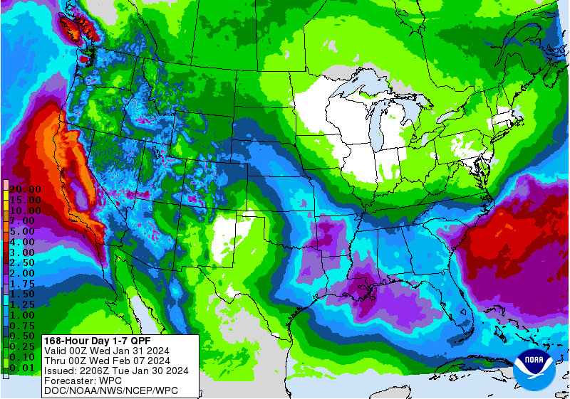
Rainfall totals will probably be about an inch or less on the Alabama side, and for Tennessee counties, generally less than a half-inch for the Southern counties, but even less than that, like a quarter-inch or lower as you get up into Middle and Northern Tennessee. Some places along the Gulf Coast could see closer to two inches. But we're concerned with the counties of North Alabama with a nod to the counties of Southern Middle Tennessee with these forecasts on this blog. So generally under one inch, and for the Tennessee folks, probably under a half-inch for most of you. We're getting the rain we need to get out of the drought though. Just a couple rainy days doesn't disrupt things too much like when we had several days of rain in a row lately, heavy rains sometimes. It's been kind of an interesting season so far.


No comments:
Post a Comment