

(Forecast)
Sunday (High 50, Low 35): Partly to mostly sunny. Seasonably cold.
Monday (High 52, Low 29): Mostly sunny and breezy during the day. Rain moving in at night with stronger wind gusts - some capable of causing scattered tree damage and/or power outages.
Tuesday (High 60, Low 43): Rain. Windy.
(Extended Outlook)
Wednesday (High 46, Low 30): Mostly sunny.
Thursday (High 54, Low 32): Mostly sunny.
Friday (High 59, Low 40): Rain likely.
Saturday (High 47, Low 33): Mostly sunny.
(Pronóstico)
Domingo (Máxima 50, Mínima 35): Parcialmente a mayormente soleado. Estacionalmente frío.
Lunes (Máxima 52, Mínima 29): Mayormente soleado y ventoso durante el día. La lluvia llega por la noche con ráfagas de viento más fuertes, algunas capaces de causar daños dispersos a árboles y/o cortes de energía.
Martes (Máxima 60, Mínima 43): lluvia. Ventoso.
(Perspectiva Extendida)
Miércoles (Máxima 46, Mínima 30): Mayormente soleado.
Jueves (Máxima 54, Mínima 32): Mayormente soleado.
Viernes (Máximo 59, Mínima 40): lluvia probable.
Sábado (Máxima 47, Mínima 33): Mayormente soleado.
(Notes)
If you'd like to keep a check on the status of our drought, you can do so here. Obviously these rain events are helping. But as of the last posting, most of us were still in moderate to severe drought conditions.
While our winters are generally mild compared to most of the rest of the country, it is still good to remember winter weather safety guidelines just in case we have one or two problem days before it turns Spring-time.
And major thanks to the people who are nice enough to follow me on Twitter, even after Elon Musk sort of goofed it up, and a lot of my posts have been adolescent "trolling" of people and stories that just about made me want to pull my hair out and look like a more stereotypical weatherman around here. Seriously though, trying to cut out the juvenile antics without losing the sense of humor. And I do appreciate all of you.
I value quality over quantity, and the quality does not get much better than Dan Satterfield, Wes Wyatt, and Meaghan Thomas. There are some other people following that I can't tell much about, but trust that they are not "bots" and are following for a good reason, won't name them since they are probably not looking for a lot of publicity with their accounts. I remember meeting one person after discussing a Smashing Pumpkins concert in Huntsville that I almost made it to last year. And that guy (or gal) kept following after our conversation. Hopefully the forecasts here are helpful to somebody up that way even though they are centered on Cullman.
Got a storm chaser named Dean Barry as an online friend there, and I figure when you've got a storm chaser following, they must find some of the info useful. Hope they don't have to drive through here any time soon, at least until March or April, if he does have to. Mike Miller has followed for a long time, a man who obviously cares a lot about the weather and does nature photography. He and my brother would get along about football, which I never watch anymore unless I'm with my brother. Well that's an overstatement; there are other people it can be fun to watch a game with, every once in a while. Most the people I used to watch it with are no longer among the living, and I was never much of a fan on my own. While politicians try to suck up to their fellow southerners by saying that they like hunting, fishing, and football just as much as the other guy, I freely admit that I'd rather walk in the woods than have to shoot anything, fishing is okay once in a while (but I usually just buy it from the store), and I'd rather watch a good chess match than a football game. Especially if Judit Polgar is one of the commentators. That Hungarian accent of hers is as endearing as Kelly Clarkson's singing voice. And there you have an example of the cornball adolescent humor surviving but without taking it too far. I don't really do trigger warnings though, so if you read long enough, you'll probably still have a time or two you think I'm a little bastard. And I can be sometimes. But I'm going to do my best to make this a quality weather blog that cuts past a lot of the gunk we all have to see on social media now.
Then I was honored to see Ms. Bree Sunshine Smith also give me a follow here lately from Nashville. And then maybe the best one lately was 101.5 FM, the radio station out of Jasper that is carrying Coyote J. Calhoun's show again. Sounds like their station manager (owner?) got him to come out of retirement. And I could not be happier about it. If you like classic rock, please consider tuning in, if you live around here. And even if you don't, it is worth catching Coyote J's show Sunday nights. Best I remember, it goes from 7 PM to Midnight. I was still a little sick and tired (caught covid from a Garth Brooks concert on Black Friday . . . if you're going to get the dreadful stuff, I can't think of a more fun way . . . unless maybe you got it from Sofia Vergara at close quarters) at New Year's, so I sipped on the fruit of the vine and got lost in that great music to ring in the new year. I plan on making it a good one, carrying on that second wind I got at Thanksgiving. So that's a nice tie-in. To all of you who have supported me even knowing you were in the minority and that I wasn't doing so well for myself: Thank you. Very much. Whether you're on the tweeter or not.
And again, if you are a native Spanish speaker, and notice room for improvement on that section of the forecast, please feel free to get in touch.


At the Noon hour, it is overcast in Cullman with a temperature of 46 degrees. The dewpoint is 45, making the relative humidity 93%. Winds are calm at the moment, though at other times during the morning, they have been variable and gusting to over 10 miles per hour. We also had some light rain and fog hanging around very early this morning. Visibility is back to 10 miles now. The pressure is 29.76 inches and steady.
Also overcast in Jasper with a High of 46 degrees. The dewpoint is 46, so the relative humidity is 100% there. Winds are from the West at 9 miles per hour. The pressure is 29.78 inches and still falling slowly. Had some light rain in the past hour or so.
Got fog and mist in Haleyville, bringing the visibility down to 3 miles. Temperature is 42 degrees, same dewpoint, so 100% relative humidity. Winds are from the Northwest at 3 mph. The pressure is 29.79 inches/1008.3 millibars and falling slowly. Actually it has been fluctuating up and down, but is currently going down again.
It is overcast and 46 in Fort Payne. Also overcast and 46 in Decatur, got West winds at 13 mph there, so a little breezy. Huntsville also a little breezy, West winds at 10 mph, temperature is also 46 there with overcast skies in the Rocket City. Muscle Shoals also a little breezy, overcast and 46. Tupelo is overcast and 44. Fog and mist, 41 degrees in Memphis, visibility down to 6 miles there. Also somewhat limited visibility in the Music City, 7 miles visibility in Nashville under overcast skies and a temperature of 45 degrees.
So the clouds are moving out more slowly and methodically than was forecast today, at least forecast by me. I thought we'd be seeing more sunshine by now. The timing of moisture that wraps around the back side of a low pressure system can be a forecast challenge. Anyway let's look at what to expect for the week to come.


High pressure will be firmly over our region tomorrow. That upper-level pattern should advect enough "warmer" air in here to support a High up near 50, Low near 35 in the morning. Skies are expected to become mostly sunny.


Then on Monday, that strong low pressure system is getting its act together East of the Rockies, moving through the Plains. That may bring significant winter storm conditions to states well to our North and West between Monday and Tuesday. But around here, the day Monday should be breezy with mostly sunny skies. Of course clouds will increase some as we get into the evening and the moisture from this system gets closer. Expecting a High of about 50 or so, lower 50's, and the morning Low dipping into the upper 20's. Because we'll have dry air in place then. The moisture comes Monday night.

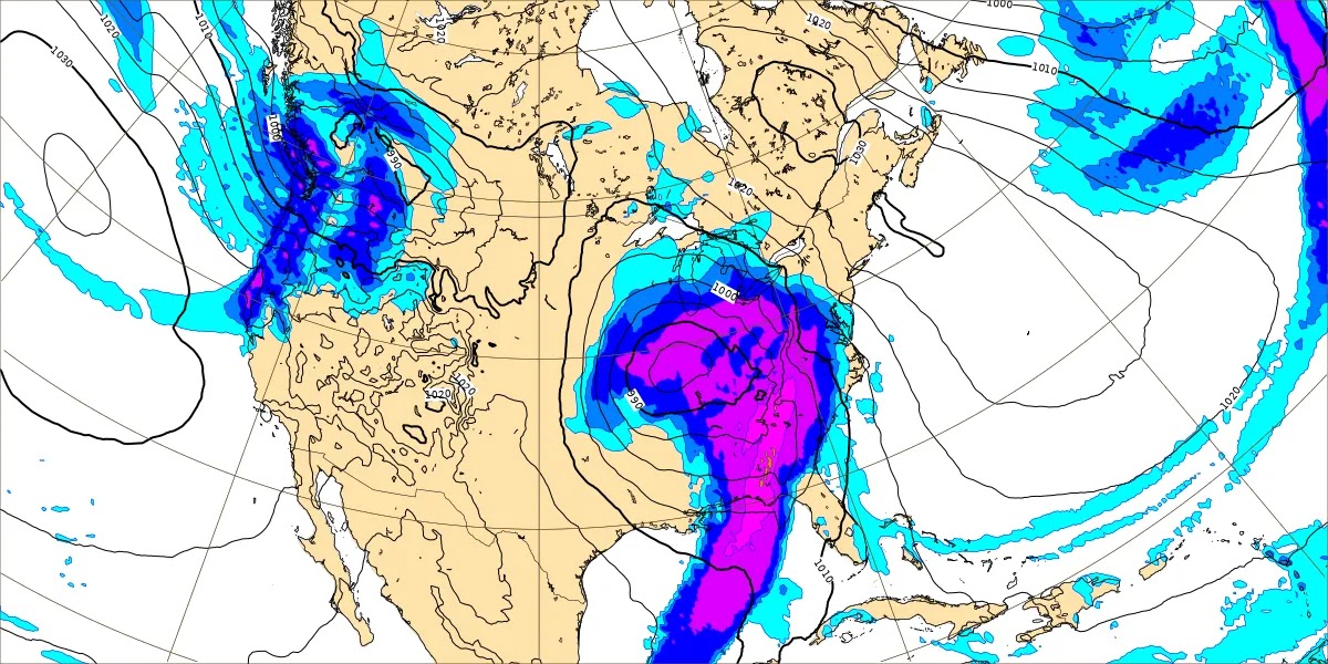
Taking an intermediate time, here we are at Midnight going into Tuesday morning. The GFS shows us covered up in rain showers. And with the strong pressure gradient from this really deep low pressure system, we will also be windy. Winds could gust up to 30-40 miles per hour or greater outside of any specific showers. And overall we should be too cool and stable for a concern about thunderstorms around here.

Which makes the NAM's look at Midnight interesting. This looks like what would be a squall line if we had enough instability to support storms. The model trends have only shown meager elevated instability though. And the temperatures really just don't support any stronger storms around here. Just sort of interesting to wonder whether we'll get a big mass of rain with strong gradient winds, and that's it, or whether there will be a focused line of showers with stronger winds despite no flashy-flashy boom-booms, i.e. thunderbumpers.

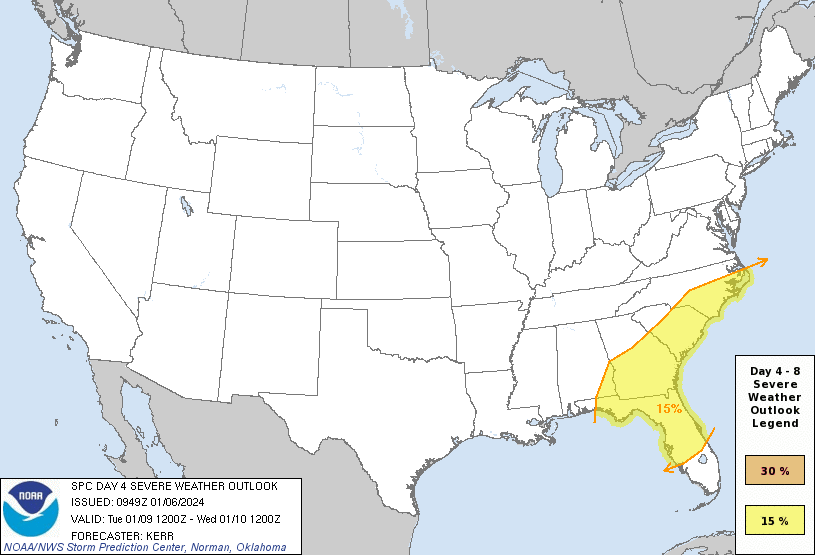
Now for about the Southern third of Alabama, Mississippi, and even back into Louisiana and clipping Texas and Arkansas, it does look like a severe weather risk will exist. And then that will shift over into Florida, about the Southern half of Georgia, into the Eastern Carolinas on Tuesday. And in those areas, all modes of severe weather will be possible. Some areas will probably experience supercell thunderstorms capable of large hail, damaging winds, and tornadoes. We're not worried about that around here, but just a heads up in case you know somebody in these other areas. Just acknowledging what a potent storm system this is, and how lucky we are here to be getting only beneficial rain and some high winds.
By the way, the high winds are nothing to sneeze at. You might consider bringing things inside ahead of time, that you wouldn't want to blow away, like if you've got a chair out on the porch or something. And we could see scattered power outages in the region from this. There is no need to clean off grocery shelves because of this potential, but if you are already shopping, you might consider buying some things that make sense if the power were to go out for a while, like some canned foods (that you can open by hand of course) or simple things like pop-tarts, peanut butter and crackers, maybe some water or whatever you like to drink that doesn't have to be in the refrigerator. I like those old yoohoo chocolate drinks for such purposes sometimes . . .
Overall we should be okay, but still, sometimes those strong gradient winds can cause people a few problems. And just making a note that if you can prepare for them a little bit, you won't get a fight out of me on that. An ounce of prevention can go a long way. Having said that, I'm not sure that I'm going to buy any extra supplies at all. If the power goes out, I'll put up with it for a few hours. It's not like I'm gonna' starve. And my cat's food is already nonperishable. His appetites are far more demanding than mine most the time anyway.


And this is Salem, 10 months old now, growing well despite having to have hip surgery a few months ago. He is sleeping peacefully now after getting his wet food on the weekend.
Back to the weather . . .


The GFS shows this occluded front and low pressure system clearing our area fairly quickly by Tuesday afternoon, the rain tapering off.
The ECMWF shows a much more gradual progression with the rain hanging around.


The GEM is on board with that slower timing, and so am I. Expecting Tuesday to stay rainy and windy with a High near 60, the Low around 40 or so, lower 40's.


Then on Wednesday, high pressure will move into the Gulf of Mexico. Now a quick note, we could see some snow mixing in with the rain late Tuesday night into the dark hours of Wednesday morning on the back side of this system. It is a possibility. But as far as any accumulation, it would probably be a dusting to a half-inch even for the high elevations of the Cumberland Plateau in Tennessee. Here in North Central Alabama, I wouldn't worry about it. If you're worried anyway, then just take it a little easier driving in case of slick spots on the roads, which is a good idea anyway when you're driving the dark hours this time of year. Some leftover rain or other moisture can always try to freeze on a bridge somewhere.
Anyway Wednesday should be mostly sunny, starting the day about 30 degrees and then warming to about the mid-40's.


Then another mostly sunny day Thursday as the high pressure moves off the coast of Georgia and Florida into the Atlantic. High should get up to the lower 50's after a Low of 30 or so.
We have a bit of model madness between the GFS and ECMWF about the timing of the next rain. Suffice to say some of it could start Thursday night. But in the interest of taking one system at a time, not going to speculate too much on exact timing right now when the best computer models can't even figure it out. Just overall Thursday should be a mostly clear day, if we see any rain then, should be evening or more likely the overnight hours.


The global models do agree on bringing another low pressure system in here on Friday with plenty of rain. Confidence is high enough to put rain in the "likely" category (more than 50% chance) even this many days out. High should rebound to near 60 degrees but probably staying just shy of it, upper 50's, the Low near 40. Some parts of the Southeast will have to monitor this system for severe weather potential, but it is looking too cool for that in the Tennessee Valley, which is how it usually goes this time of the year.


Saturday we get a shot of cold air. We'll be mostly sunny with a High in the mid-to-upper 40's and a Low down in about the mid-30's.
With a pattern this dynamic, not going to do 10 days up top in the official forecast, but will speculate a little beyond seven days out here in the discussion. Those of you who take the trouble to read this know to take it with a grain of salt.
High pressure should move in next Sunday so that we stay sunny, High around 50, starting the day closer to 30 or even upper 20's with good radiational cooling conditions and the high pressure moving in behind the front. Then both the GFS and ECMWF want to bring back rain chances for Monday, which I believe is Martin Luther King Jr. Day. The European solution is a lot more aggressive. And already you can see why I'm not including this in a forecast. There is enough to sort out in just the next seven days. If I was forced to make a forecast, I'd put a rain chance of about 30-40% (more likely 30%) and put the High in the upper 40's, Low in the lower 30's.


We do need the rain, and we'll see an average of about 3 inches of it for this forecast period. The totals may drop off for Middle and Northern Tennessee, closer to 2 inches.


As far as any risk for flooding issues, the risk looks very low around here, but the folks at risk for severe weather with this Monday/Tuesday system will also want to monitor for locally heavy rainfall. Any significant risk of that is well South of here, and as noted before, we are staying too cool for any severe thunderstorms, but are likely to have high gradient winds that are not associated with specific showers or storms.

The snow should stay well to our North, except some minor accumulations are possible along the Cumberland Plateau in Tennessee. Even there, would be surprised to see amounts higher than a half an inch.
Thanks for reading. See you in the funny papers.


No comments:
Post a Comment