Monday, February 19, 2024

Plenty of Sunshine and Seasonable Temperatures, Some Rain Thursday Night

Tuesday (High 60, Low 30): Mostly sunny. Cold in the morning, cool in the afternoon.

Wednesday (High 67, Low 36): Mostly sunny. Seasonably cool.

Thursday (High 68, Low 49): Partly to mostly cloudy with isolated showers possible during the day. Then showers are likely at night - an isolated thunderstorm is also possible in the mix. 

Friday (High 61, Low 47): Mostly sunny. 

Saturday (High 63, Low 34): Sunny.

Sunday (High 69, Low 38): Sunny.

Monday (High 72, Low 50): Partly to mostly sunny. 

SKYWARN classes are being held in advance of our main severe weather season. These are free and are a great way to review severe weather safety as well as learning things that help out your community. 

This Saturday is also Severe Weather Awareness Day in Nashville. 

That radio station that suffered a bizarre theft, 101.5 FM in Jasper, is back on the air thanks to the great folks at iHeart radio in New York. So I guess I will only plug that station's GoFundMe page to raise money to get a new tower this one more time. It was great to hear Coyote J back on the air last night. You'll hear stuff on that show that you've never heard anywhere else, even if it's a remaster of a song you know. 

Skimming back over George Washington's farewell address today, I can't help thinking what a novelty it would be to hear a politician speak with even half this much class or eloquence anymore. Not to mention that when he mentions the "Almighty," he doesn't sound like a raving nut or like he's just throwing that in there to please his fan base. Sounds like he might have actually meant it, that he was deferring to a higher Providence, in case his own judgement wasn't enough . . . such a novelty. 

At 3:24 PM we have fair skies in Cullman, plenty of sunshine, calm winds, low humidity, high barometric pressure, and are at 57 degrees. Looks like that will be our High. The Low this morning was all the way down at 21. Jasper is up to 59 degrees this afternoon after also having a Low of 21. And Haleyville has gotten up to 57 this afternoon, had a Low this morning of 20 degrees. 


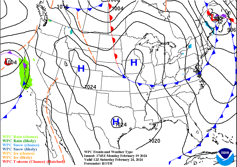
A weak upper-level disturbance will bring us some clouds tonight, but the air is probably going to stay too dry for much fog to develop. Tomorrow high pressure stays in place over our region, and we'll be mostly sunny with a High near 60, Low near 30. Then on Wednesday, again mostly sunny even as the high pressure starts to move a little to our East, a High in the upper 60's and Low in the mid-30's. 


Then on Thursday, the GFS and NAM are both showing the best chance of rain coming in the evening and at night. But we could see something isolated during the day. Just about everybody will see a shower or thunderstorm Thursday night though. High on Thursday should be in the upper 60's again, the Low near 50, maybe upper 40's. 

Clearing looks pretty quick behind that front. Friday should be mostly sunny with a High of 60 or so, Low in the mid-to-upper-40's. 


Model guidance has backed off on how much of a cold snap we get behind this front, not looking like much of one now. Saturday looks sunny with a High in the lower 60's, Low in the mid-30's. Sunday also looks sunny with the High in the upper 60's and the Low coming up to the upper 30's, some of us could even see 70 by Sunday. Winds will be out of the South by this time, and this may be a preview of the kind of weather March will bring. Then Monday looks like it will bring a High of 70 or so, the Low rebounding well into the 40's, upper 40's. Mostly sunny skies. 

And then beyond the scope of this technical forecast period, just peeking at days 8-10, we will have some rain chances returning Tuesday or Wednesday. The GFS seems to gradually be coming into line with the slower ECMWF solution of the main rain/any thunderstorms arriving Wednesday. Expecting a High in the 70's. And if that solution verifies, both models make it look like it kicks out of here by Thursday, and we'd be back in the 60's with mostly clear skies. We might have to watch for some stronger storms by Wednesday, and we are nearly into March, prime time of the year for that sort of thing, but glancing at the GFS projections of instability and wind shear, right now it looks like the more organized chance of that would be up in Northern Tennessee and into Kentucky, well North of here. And really, this far in advance, it is almost like reading tea leaves. Which is why usually I'll just mention it in passing in the discussion but not actually put it up top in the actual forecast. Seven days is enough to try to predict accurately. 


This 7-day forecast period looks pretty clear cut anyway. We'll have some showers Thursday night, but that's our only real window for rain, besides a low chance during the day Thursday or some lingering early Friday. And our average rainfall totals will be generally less than a quarter of an inch. 

No comments:

Post a Comment

Tornado Watch

Well this has escalated quickly. Note we do have a Severe Thunderstorm Warning for Northern Wayne County in Tennessee. Also includes Lewis, ...