(Forecast)
Wednesday (High 67, Low 36): Mostly sunny. Seasonably cool.
Thursday (High 69, Low 48): Partly cloudy and breezy with widely scattered showers/a thunderstorm possible during the day. Rain showers are likely at night, but the rain is expected to be light.
Friday (High 61, Low 47): Mostly sunny and still a little breezy. Some clouds or an isolated shower may linger in the early morning.
(Extended Outlook)
Saturday (High 60, Low 34): Sunny.
Sunday (High 66, Low 35): Sunny.
Monday (High 70, Low 46): Mostly sunny.
Tuesday (High 72, Low 54): Partly cloudy with a 30% chance of showers/thunderstorms.
(Notes)
A week from today, there is a SKYWARN class 6 PM Tuesday at the Limestone County EOC in Athens. There are also several online classes scheduled, though it is two different offices offering them respectively. Bottom line, these classes are free, and anyone who wants to learn more about severe weather is strongly encouraged to take one.
If you're close to Nashville, they are having a Severe Weather Awareness Day this Saturday at Trevecca University, looks like a great event.
And we are just about out of our drought now.
(Discussion)
At 1 PM, latest observations at Cullman show sunny skies. The temperature is 59 degrees. The dewpoint is 21 degrees, making the relative humidity 23%. Winds are variable at 3 miles per hour. The pressure is 30.25 inches and falling slowly. The Low this morning was 34.
Skies are also sunny in Jasper, with a temperature of 63 degrees. The dewpoint is 27, making the relative humidity 25%. Winds are calm. The pressure is 30.24 inches and falling slowly.
It is sunny and 62 degrees in Haleyville. The dewpoint is 28, and the relative humidity is 28%. Winds are from the Northwest at 8 mph. The pressure is 30.26 inches/1024 millibars and falling slowly.
Elsewhere around the area, Fort Payne is sunny and 58 degrees. Decatur is sunny and 61. Huntsville is also sunny and 61. Ditto for Gadsden. It is sunny and 63 in Muscle Shoals. Tupelo's observations are currently unavailable, but they got up to 59 degrees by 11 AM. It is sunny and 65 in Memphis, Southwest winds gusting up to 15 mph there. Nashville has clear skies and 61 degrees.
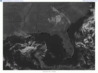
We do have a weak upper-level trough of low pressure moving through the region today, caused some mid-level and high clouds this morning, some of those you can still see on the satellite imagery. But for the most part, our weather is dominated by the strong high pressure centered down around Biloxi, MS. We'll probably top out around 63 degrees this afternoon. Skies will stay mostly sunny.
Tomorrow we'll have Northwest winds aloft, high pressure at the surface down along the Gulf Coast keeping us mostly sunny. Should start the day in the mid-30's, about 35-36, and then reach the mid-to-upper-60's in the afternoon, about 65-67.
As we get closer to Thursday's rain event, models are wanting to bring the moisture and chances for precipitation in here earlier, when for a while it was looking like we'd mainly just have showers at night.
The NAM makes it look more likely to start during the afternoon than the GFS does, over more of North Alabama. Still going to keep rain chances scattered during the day, about 30-40% chance, so that's about a 1-in-3 or 2-out-of-5 chance at getting a shower or thunderstorm while it is still daylight. Based on past experience with setups like this and my intuition, I'm leaning more toward the 30% probability, keep the rain chances low during the day.
Rain showers are likely overnight Thursday night going into Friday. And an isolated thunderstorm or two is possible. But for most places, rain should not be especially heavy. Overall we're expecting light showers.
The High Thursday should be in the upper 60's again, the morning Low in the upper 40's.
Then Thursday night/Friday morning the Low again should be in the upper 40's, could be about 50 for some places where there is more muggy air than there is rain-cooled air.
Then behind the front on Friday, we should get up to about 60 degrees, or MOS is showing 61 technically, close enough, not much of a cooldown behind this one. But skies will be mostly sunny. I think most of the moisture will be out of here before daybreak.
Since raw model data can be tough to read for people who don't follow the weather all the time, here are some more mainstream maps from the WPC that show the front pushing through the region Thursday into Friday.
Once again by Saturday we will have high pressure building into the region, centered out along the Texas coast, Northwest winds aloft. We'll have sunny skies, High of 60 or so, the Low in about the mid-30's. And as I saw one forecaster point out today, we're due for a comfortable weekend for a change.
Sunday looks like another sunny day with comfortable temperatures, warming up to the mid-60's if not upper-60's, the Low staying down in the mid-30's. That's about as easygoing as it gets in February.
Looks like a few clouds will come back on Monday as we get ready for a pattern shift. But still more sunshine than clouds. The High should get up to about 70, and the Low should rebound into at least the mid-40's, but well into the 40's.
Then Tuesday it looks like lower 70's for the High, the Low temperature rebounding into the 50's. And we have another cold front on the way. For now will only include a 30% chance of rain for Tuesday, and that will probably come in the evening and night hours.
Rainfall totals for the next seven days should be less than a quarter-inch for most places even up across the Tennessee line. And for most of North Alabama, more like less than a tenth of an inch. So these showers are expected to be light. Even if we do see an isolated thunderstorm or heavier shower somewhere, can always have that, overall this is a minor rain event that will help us finish coming out of our drought, which is just about over now anyway.
Looking into the land of tea leaves, next Wednesday it does look like we'll get another cold front moving through here, with showers and thunderstorms likely, High near 70, Low in the 50's.
Then it looks like we are in the clear again for Thursday.
The ECMWF does show a slower progression, but the lingering rain looks like it'll mainly stay over South Alabama even if this slower solution verifies.
So we're probably looking at partly to mostly sunny conditions Thursday with a High in the 60's, Low in the 40's.
Then next Friday, mostly sunny skies, High in the 60's, Low in the 40's.
And understand that I'm only peeking out 10 Days here in the discussion to show general trends, mainly because we have rain on the way just beyond the scope of this main 7-Day forecast period. Not going to include 10 days in the forecast up top. Just chatting about it here.
For anybody who keeps up with my cat chronicles, Salem seems to like that Surfin' Turfin' kind of dry food. He was not a fan of a new wet food I tried for him over the weekend, which I think was also Friskies, had some whitefish in it, which I get the idea he doesn't like. He did like the salmon wet food he got on Saturday, which was Sheba brand. My bestie deserves the best. He sure was hyper last night and kept waking me up though. He is slowly learning to save his attacks for things like leftover packaging ties instead of trying to chew up earphones or things like a cell phone cord. I'm going to take him out more in this nicer weather. Still debating on whether he needs the harness or if we know each other well enough now that just my being there will keep him out of trouble. He can be unpredictable sometimes, and unfortunately, the neighborhood I live in has become increasingly unsafe for cats. He's almost a year old, and I plan to keep him for at least a decade, which I think is a reasonable lifespan to expect from a creature as feisty as he is.


No comments:
Post a Comment