

FORECAST:
Friday (High 64, Low 50): Mostly cloudy, mild, and breezy. Numerous rounds of rain showers are possible through the day and night.
Saturday (High 65, Low 56): Rain. An isolated thunderstorm is also possible.
Sunday (High 62, Low 53): Rain continuing. There may be brief breaks in the rain, but numerous periods of showers are expected throughout the day and night.
EXTENDED OUTLOOK:
Monday (High 60, Low 50): Cloudy with a 50% chance of lingering showers.
Tuesday (High 51, Low 32): Mostly sunny.
Wednesday (High 56, Low 29): Sunny.
Thursday (High 61, Low 33): Sunny.
READING TEA LEAVES:
Friday February 16th (High 54, Low 36): Mostly sunny.
Saturday February 17th (High 55, Low 38): Partly to mostly cloudy with a 40% chance of showers.
Sunday February 18th (High 53, Low 37): Rain likely.
PRONÓSTICO:
Viernes (Máxima 64, Mínima 50): Mayormente nublado, templado y ventoso. Es posible que se produzcan numerosas lluvias durante el día y la noche.
Sábado (Máxima 65, Mínima 56): Lluvia. También es posible que se produzca una tormenta aislada.
Domingo (Máxima 62, Mínima 53): La lluvia continúa. Es posible que haya breves pausas en la lluvia, pero se esperan numerosos períodos de aguaceros durante el día y la noche.
PERSPECTIVA EXTENDIDA:
Lunes (Máxima 60, Mínima 50): Nublado con un 50 % de probabilidad de lluvias persistentes.
Martes (Máxima 51, Mínima 32): Mayormente soleado.
Miércoles (Máxima 56, Mínima 29): Soleado.
Jueves (Máxima 61, Mínima 33): Soleado.
LEYENDO HOJAS DE TÉ:
Viernes 16 de febrero (Máxima 54, Mínima 36): Mayormente soleado.
Sábado 17 de febrero (Máxima 55, Mínima 38): Parcialmente o mayormente nublado con un 40 % de probabilidad de lluvias.
Domingo 18 de febrero (Máxima 53, Mínima 37): Probable lluvia.
NOTES:
This is Severe Weather Awareness Week for Alabama and Tennessee. Our severe weather season for the Tennessee Valley is mainly in March, April, and at least part of May. Often we have a secondary peak in severe weather in November.
If you or anyone in your family is interested in learning more about weather, and can get to Huntsville this Saturday, Rocket City Weather Fest is happening at UAH. Could be worse. Could be rainin'.
We had an Amber Alert today in Decatur, but the missing person was found safe in Huntsville, and the alleged abductor was arrested. Always glad when those stories end for the best.
Not such great news in the world of climate, as last year was the warmest on record worldwide.
And some meth-heads (or some similar kind of idiots) stole the AM tower to WJLX, the fine radio station in Jasper that hosts Coyote J's Cemetery of Rock. That takes some effort, I would think. I hope they catch the bastards and give them more than a slap on the wrist. Even newspapers in Britain think this is a wild and crazy story. Since the FM tower is still working, I encourage everyone to check out that station if you never have, and like rock music from the 90's, 80's, or 70's. They play a great variety, but I think it's all stuff before the year 2000. I'm not sure that year was the cutoff point, but I know there came a time when Taylor Swift and Kelly Clarkson were about the only ones who could still put out good albums consistently. Which is depressing if you're a rock fan. So more power to the classics. Even though I like the good new stuff when I do occasionally hear it.
Adding this later in the evening - the owner of 101.5 FM WJLX in Jasper has set up a page where people can read more about the vandalism/theft they've recently suffered and make a donation if they like. They are not allowed to be on the air until their AM tower is replaced, but they are streaming online. If you like classic rock, it's as good a station as you'll find. Maybe Coyote J will stay with them, because his show adds something special and is how I discovered the station.
And I'm not sure how I forgot to mention earlier that Taylor Sarallo is back on the air, staying in the Birmingham market, working with NBC-13 now, where Jason Simpson is the lead meteorologist and you've got other good people that've been there forever like Stephanie Walker. I use a lot of sarcasm on this blog, even when I try not to, but it is with complete sincerity that I congratulate Ms. Sarallo on this step in her career and say that she is about as good as it gets in broadcast meteorology.
DISCUSSION:


As we approach 1 PM, skies are mostly sunny across the Tennessee Valley with a good southerly breeze. The temperature in Cullman is 55, with a dewpoint of 32 degrees, making the relative humidity 41%. Winds are from the South at 13 miles per hour, with higher gusts up to 21 mph. The pressure is 30.23 inches and falling slowly. The Low this morning was 45, and I believe the forecast was for 39, so not as much radiational cooling overnight as expected this time.
In Jasper, it is 57 degrees under sunny skies. The dewpoint is 36, making the relative humidity 44%. Winds are variable at the moment, been out of the Southeast much of the morning, at 5 miles per hour, with higher gusts up to 12 mph. The pressure is 30.21 inches and falling. The Low this morning was 32, so they did get plenty of radiational cooling.
It is mostly sunny at Haleyville, which has a few more clouds this morning than the other sites. The temperature is 56 degrees with a dewpoint of 34, making the relative humidity 44%. Winds are from the South at 8 miles per hour with higher gusts up to 16 mph. The pressure is 30.22 inches/1022.5 millibars and falling. The Low this morning was 44 degrees.
Elsewhere around the area, Fort Payne is sunny/breezy and 53. Ditto for Gadsden. Huntsville is mostly cloudy and 54 degrees, breezy as well. Just assume all sites have a southerly breeze going on today. Decatur is sunny and 55. Muscle Shoals is partly cloudy and 60. Ditto for Tupelo. Memphis is overcast and 63 degrees and even more breezy than other sites, with South winds gusting up to 25 mph. Nashville is mostly cloudy and even breezier, winds sustained at 21 miles per hour from the South, higher gusts to 28 mph, and a temperature of 61 degrees there. Was going to mention Savannah, in Hardin County, Tennessee, but their last report appears to be from February 1st, so . . . that's not gonna' work. Fayetteville is sunny and 55. Ditto for Winchester.
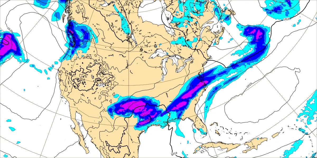
We do have isolated showers in the region, a little ahead of schedule, and clouds are gradually on the increase today. We'll probably get up to about 62-63 degrees this afternoon.
The high pressure system is moving off into the Atlantic as our next cold front approaches from the Eastern Plains and Midwest.


The Climate Prediction Center thinks that as we get into the latter part of the month, we'll be a little colder than average, and have precipitation amounts at about average levels, maybe a little above for far North Alabama into Tennessee.


No comments:
Post a Comment