

FORECAST:
Today (High 69): Overcast and breezy. An isolated shower is possible.
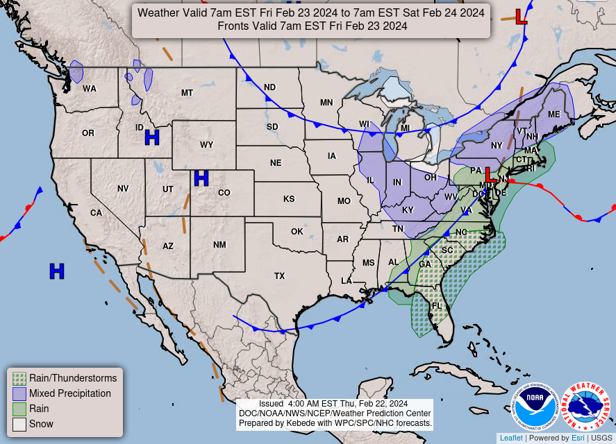
Tonight (Low 50): Showers likely with periods of gusty winds. Isolated thunderstorms are also possible, and a stronger storm cannot be ruled out, especially in Northwest Alabama.
Friday (High 63, Low 50): Partly to mostly sunny. Clouds gradually decreasing throughout the day, staying breezy.
Saturday (High 58, Low 40): Sunny. Still breezy.
Sunday (High 66, Low 30): Sunny. Cold in the morning, cool in the afternoon.
EXTENDED OUTLOOK:
Monday (High 70, Low 46): Mostly sunny.
Tuesday (High 76, Low 57): Partly to mostly cloudy.
Wednesday (High 73, Low 61): Thunderstorms likely - some could become severe.
Thursday (High 56, Low 47): Mostly sunny.
PRONÓSTICO:
Hoy (Máxima 69): Nublado y con brisa. Es posible una lluvia ducha aislada.
Esta Noche (Mínima 50): Probables lluvias con períodos de ráfagas de viento. También son posibles tormentas aisladas y no se puede descartar una tormenta más fuerte, especialmente en el noroeste de Alabama.
Viernes (Máxima 63, Mínima 50): Parcialmente a mayormente soleado. Las nubes disminuirán gradualmente a lo largo del día y se mantendrán con brisa.
Sábado (Máxima 58, Mínima 40): Soleado. Todavía con brisa.
Domingo (Máxima 66, Mínima 30): Soleado. Frío por la mañana, fresco por la tarde.
PERSPECTIVA EXTENDIDA:
Lunes (Máxima 70, Mínima 46): Mayormente soleado.
Martes (Máxima 76, Mínima 57): Parcialmente a mayormente nublado.
Miércoles (Máxima 73, Mínima 61): Es probable que haya tormentas eléctricas; algunas podrían volverse severas.
NOTES:
This weekend, many severe weather preparedness items are tax-free. So if you need fresh batteries for a weather radio, or need to get a weather radio to begin with, it is a good time to do so.
The National Weather Service in Nashville is having Severe Weather Awareness Day this Saturday at Trevecca Nazarene University. For anyone superstitious about the word "Nazarene", don't worry, there are no regulations on what your hair looks like. But to continue on a more serious note, the Nashville office is also hosting some Weather Safety Basics classes, the next one is online this Monday evening.
The National Weather Service in Birmingham is holding SKYWARN classes, mostly online, and the Huntsville office has an in-person class in Athens this Tuesday evening. If you have ever wanted to be trained as a storm spotter, you are strongly encouraged to check out one of these classes, since they are free and do not require any previous training. They're fun for people interested in severe weather, and it helps us all out to have people watching the skies who are reliable in what they report.
Even though our severe weather potential this coming Wednesday looks like it may be on the lower end, it is a good time to review your severe weather safety plan. As we get further into the months of March and April, most years we see several days with potential for organized severe weather. I could rattle off my own ideas about preparedness in this space, but for now, I'd rather encourage you to take advantage of these free resources being offered by our local government agencies whose people are devoted to protecting life and property when the weather turns threatening.


At 10 AM skies are overcast in Cullman. The temperature is 57 degrees. The dewpoint is 52 degrees, making the relative humidity 82%. Winds are from the Southwest at 12 miles per hour, with higher gusts up to 21 mph. The pressure is 29.99 inches and falling. Because of the cloud cover, our Low this morning only got down to 52 degrees.
It is also overcast in Jasper. The temperature is 59 degrees. The dewpoint is 55, making the relative humidity 88%. Winds are variable in direction at 7 miles per hour, with higher gusts up to 17 mph. The pressure is 29.99 inches and falling.
Haleyville is overcast and 59 degrees. The dewpoint is 51, making the relative humidity 75%. Winds are from the Southwest at 14 miles per hour, with higher gusts up to 22 mph. So as expected, it is a breezy day around the Tennessee Valley. The pressure is 29.98 inches/1013.9 millibars and falling.
Elsewhere around the area, Gadsden is overcast and 57 degrees. Fort Payne is overcast and 55. Huntsville is mostly cloudy and 60. Decatur is overcast and 60, South winds gusting all the way up to 28 mph there. Muscle Shoals has similar wind gusts from the Southwest, overcast and 63 degrees there. Tupelo is overcast and 61, South winds gusting up to 23 mph. At Memphis, the South winds are gusting all the way up to 39 mph, mostly cloudy skies and 62 degrees there. Savannah is overcast and 59 degrees, South winds gusting to 25 mph. Columbia is overcast and 59 degrees, South winds gusting to 25 mph there. Nashville is overcast and 61 degrees, South winds gusting to 24 mph. Similar wind gusts for Fayetteville, back closer to home base, along the AL/TN state border, overcast and 57 degrees in Fayetteville at this hour.


The main story for our weather in the main short-term part of the forecast is this cold front that will drop through the area tonight. It'll bring some light rain showers, and then not much of a cooldown behind it this weekend, just a little bit. It will be the middle of next week before we see more rain chances, actually some storm chances then, so let's dig into the details day by day.
First off, the rest of today, we'll stay cloudy and breezy, with a High in about the 67-69 range. If we see any rain during the day around here (North Alabama/Southern Middle Tennessee), it should stay isolated, about a 1-in-5 chance of any one spot getting a shower or thunderstorm. Rain showers are likely overnight tonight, and a thunderstorm or two could happen in the mix. The Low for tonight/tomorrow morning should be about 50 degrees. Most of these rain showers should be light and should be over before daybreak tomorrow.


For the most part, we are not worried about any stronger thunderstorms with this system. However, based on some guidance from the HRRR (a convection-allowing model that does forecasts for the really short-term), the Storm Prediction Center has outlooked a small part of Northwest Alabama back into Northern Mississippi for the possibility of a few thunderstorms being able to develop in marginally unstable air and reach severe limits. This risk is very low, and if it happens, such activity will stay isolated. If you live in these areas though, it is always good to be prepared.


The rain should be out of here by tomorrow morning, but clearing of clouds throughout the day may be more gradual. We'll be staying breezy with winds shifting back around to the Northwest. I think we'll be mostly sunny by the afternoon. High should get up to about 63 degrees, after a morning Low of about 49-50.


Then on Saturday, as our upper-level wind flow is from the Northwest and high pressure builds back into our region from the Midwest, we'll feel the effects of that much drier air. The Low should get down to about 40 Saturday morning, and then in the afternoon, we'll struggle to warm up to even 60 degrees. And we'll continue to have breezy conditions as a shortwave trough continues pushing through the Appalachian mountains.


After that, our upper-level pattern really changes on Monday with good Southwest flow at 500 millibars bringing some warmer air and some moisture in here. This coming week will be the warmest we've been so far this year. And we are nearly into Spring time. It is nearly March. Sometimes, time flies whether you're having fun or not. Time flies like an arrow, but fruit flies . . . like a banana. (Credit to magician Paul Harris for that joke. So throw the tomatoes at him.) Quite a temperature contrast for the morning Low, from Sunday, starting the day in the upper 40's, before warming to a High near 70 on Monday.


Tuesday looks like we will be clouding up and turning breezy, also really warming up, don't think we see any rain yet, even in Southern Tennessee counties. The High should get up into the mid-70's with a morning Low rebounding well into the 50's.


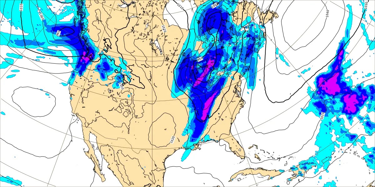
Wednesday is looking more like our main day for rain and thunderstorms. And when you get this rapid a warm-up this time of year with a storm system coming in, the potential for severe weather is always a concern. Having said that, two points against a really organized severe weather threat here are that the upper-level trough is forecast to be positively tilted, and the surface Low pressure system is forecast to be centered way up around the Great Lakes.
If you look at the top graphic, the 500 millibar maps from the GFS, notice that if you drew a line through that big dip in the lines ("heights") back over the Plains, the straight line you drew down through that dip, or "trough" in the upper atmosphere, would lean diagonally to the right. The top part of the line would lean to the right. That's what we call a "positively tilted trough." Usually for organized severe weather, we would want to see such a "trough axis" leaning to the left.
And while none of these rules are set in stone or can be relied on all by themselves, usually the severe weather from a storm system like this will be located closer to the center of low pressure. You look at the bottom map shown above, the GFS projections of how things will be down at the surface, notice the big L is up in the Great Lakes region. So the Ohio River Valley is more likely to see severe weather from this than we are in the Tennessee River Valley. Just a couple of synoptic weather points to consider when evaluating all the social media stuff. Usually I don't see as much social media hype as I hear some of the older forecasters griping about. I assume that's because I'm not as well-known as the weather people you see on television or who hold respected positions in the National Weather Service, and also because I refuse to be on social media 24/7, so I miss a lot of stuff. I choose to miss a lot of stuff these days. But this time, I've been slightly aggravated by the messaging from some people about this storm system, including some people in the broadcast world, even a couple of people I like. Some sources are overselling this. It reminds me of a co-worker my brother had one time in Marshall County, who said that a certain forecaster had to be shown from the waist up, he got so excited when the weather was bad. Once in a while, these average people have a point about forecasters jumping the gun and making too much out of things.


The reason it irritated me this time was that I came across some of the hype last night, and it made me think I had missed something, that there was new data in since I'd last posted a forecast. Until I followed the links. And then I was thinking: These people should know better. Anyway, I have no control over anybody's say-so but mine. And I'm guessing some of these better meteorologists are under pressure from the bigwigs at the TV stations to make the weather sound more sensational than it really is.
There is reason to be watching trends for next Wednesday with regard to severe weather potential. But there is a lot of uncertainty about how this will play out, since we are nearly a full week away from it still. And the main two global models, the GFS and the ECMWF, do not even agree on the timing, still. These graphics above are from the European (ECMWF) at Noon, 6 PM, and then Midnight. And you can see that the GFS still has the faster timing, although it has come closer to agreeing with the ECMWF as we get closer to the event. And timing can make a big difference with regard to how unstable the air gets. That's one of the three ingredients we need for severe weather. The three ingredients that need to come together in a pretty good balance are: 1. Unstable air 2. Wind Shear 3. A Source of Lift to get updrafts going.
For now I still think thunderstorms are likely at some point Wednesday or Wednesday night and that we will have to watch for the potential of severe storms. High should be in the 70-75 degree range, probably lower 70's, the Low near 60. Will analyze the severe weather potential in detail below, to show why I think it's on the lower end with this system, and also to make sure I don't need to reconsider anything, if any trends do make it look likely to be more of an organized threat, that I'd be more concerned about.
And any severe weather threat is worth taking seriously, even that really marginal risk in Northwest Alabama this evening/tonight. It's always better safe than sorry. But it is not worth getting bent out of shape six days before what will probably be a lower-end threat either. Sometimes I think it's important to communicate to people when things are basically okay, or when there is a threat, but it's not a really major threat. There are enough legitimately troubling things in the news these days, and if we make it sound like the sky is falling for every single severe weather threat (and we typically have a lot of them in March, April, and May), people just start to tune it out. So if any of the hype has scared you about next week, please take a deep breath, read on, and think about it logically.


Looks like we will become mostly sunny again for Thursday, when the two global models strangely start to agree again. And it looks like a decent cooldown, the High back in the 50's, the Low perhaps dipping back into the 40's.
Now that is a point in favor of having some stronger storms, that might become severe, that this is a strong enough front to cause such a temperature shift.
So let's look at the pros and cons for severe weather next Wednesday, try to use logic and call it straight down the middle.
The first thing to say is that six days in advance, the ability to look at different forecast parameters is limited. It's better when you get within about 72 hours of the event, when the mesoscale models can take a look at what the atmosphere will probably set up like. But the global models can also look at this. So since there is already hype, let's look at what we can.
I've already shown the synoptic setup, where we do have a fairly strong cold front coming in, right in time for the start of our typical severe weather season for the Tennessee Valley (March, April, and May). But then the upper-level trough is forecast to be tilted the wrong way, from what we'd normally look for, for an organized severe weather threat. Plus the low pressure system is expected to be well to our North, which usually also means that the threat for organized severe weather will stay to our North. So that's one point in favor of severe weather around here, and two points against it.


The simulated radar from the GFS makes it look like a squall line approaching Northwest Alabama in the evening and then still slowly moving through North Alabama/Southern Middle Tennessee at Midnight going into Thursday morning. This would be consistent with the timing the ECMWF, the other major global model, was showing when we were just looking at the synoptic setup.
As some forecasters from the National Weather Service noted in their discussions, it's really too soon to be looking at this stuff and trying to iron out details with confidence. The only reason I'm showing it is that this time, I saw what struck me as really annoying hype. And I want to balance it out with the facts. Like if you want to play that game, at least know what's really going on.


The energy-helicity-index, measuring a combination of instability and wind shear that we'd need (we have the source of lift, a stout cold front) for organized severe weather, is really not looking that impressive around here on Wednesday. Though between 3-9 PM, it does shift from Central and Northern Mississippi more into Northwest Alabama.


The Convective Available Potential Energy values all the way to Midnight between Wednesday/Thursday are looking like they will stay below 500 joules/kilogram around here. And 500 joules is roughly the baseline of how much unstable air you'd need for severe weather. Even when we have stuff in November, when it's really hard to get unstable air, if the instability is forecast to be this weak, most forecasters are thinking that we probably won't get much severe weather from this system, but we'll watch it just in case. From my personal experience, when you get weak instability as it gets toward Spring time, the chance of having severe weather is even lower than it would be in the cool season, even if you have good wind shear and a good source of lift.
Again, you can't really rely on specifics six days in advance. But if it's worth hyping up on these other sites, then it is worth looking at objectively here. Ultimately we all have to keep an eye on it and just see how things trend over the next few days. But I'm going into the details as an antidote to the hype. Because it got on my nerves this time.

.png)
.png)
.png)
The wind shear does look strong with this though. When you see Helicity values (up to 3 kilometers) of 200 m^2/s^2 or more, that's roughly the baseline for getting thunderstorms to rotate. And this is showing values in the region of 200-400 units between 3 PM Wednesday and Midnight. And I will say, as much as I don't like the hype train, that this is the right time of day/night to get severe weather, if you also get enough unstable air. So this will bear watching.
So what do we have so far? It is a strong-enough cold front, but the trough looks like it will be positively titled, and it looks like the surface Low will go way, way North of here. So one out of those three things makes it look like severe weather around here.
And then we have plenty of wind shear, even the kind that would support tornado development, but our instability is looking marginal at most. Considering the time of day and the overall pattern, there is a chance the global models haven't picked up on more instability yet. And we've only been looking at the GFS for parameters.

It's not as easy to find public domain graphics from the ECMWF for specific parameters, but it is showing dewpoints coming up into the lower 60's for the Tennessee Valley on Wednesday afternoon. This would suggest enough instability to work with, especially considering the strong wind shear, even though the low pressure system is so far displaced to the North.
And I started to look at more European data, but then ran into the fact that the new run of that model is still coming in and isn't quite caught up to that time range yet. Which reminded me of the bottom line, which is that all of us will simply have to wait and see the trends over the next few days. This does look somewhat concerning for severe weather potential, like we need to keep an eye on things. But there is no really strong evidence that we'll have really organized severe weather around here, not yet. We might see that evidence later, especially if the Low were to take a more southerly track, but as of right now, our severe weather potential looks more likely to be on the lower end of the scale. With only a couple of points that make a forecaster stop and go "hmmmmm."
But to make it sound like a really big deal when it's still nearly a week out, defeats the purpose, will hurt us when we do have a threat that really does look organized and significant, even several days in advance. Because some people will think it's just more moving the wind around.


I agree with the Storm Prediction Center forecast. For Wednesday, they have outlooked a broad area for a basic 15% risk of severe thunderstorms during the day and night, not only down in Alabama, Tennessee, and Mississippi, but back into Arkansas and up into Kentucky and parts of Ohio, Indiana, and Illinois, also Southeast Missouri. Northwest Georgia is clipped by this risk.
If I had to bet on a place getting an upgrade to a more enhanced risk, it'd probably be somewhere in Kentucky and Tennessee, maybe adjacent parts of those states like Ohio and Indiana. But it is really too soon to call.
The discussion from SPC is quite the opposite of hype:
Day 4-8 Convective Outlook
NWS Storm Prediction Center Norman OK
0333 AM CST Thu Feb 22 2024
Valid 251200Z - 011200Z
...DISCUSSION...
Medium-range models continue to show a powerful mid- to upper-level
trough ejecting into the central U.S. by late Tuesday into
Wednesday. A deep cyclone is currently progged by most ensemble
members to move from the central Great Plains into the Great Lakes
vicinity. Preceding this upper trough, an antecedent re-charging of
steep lapse rates associated with an elevated mixed layer over the
southern High Plains is forecast. A few days of airmass
modification, both in terms of ambient temperature and moistening
over the Gulf Basin, will occur in wake of frontal passage on
Saturday. Northward moisture return beneath the aforementioned EML
will probably result in a substantial warm sector by late afternoon
Tuesday and into Wednesday farther east. Model run-to-run
continuity is such that there is increased confidence in the
introduction of 15-percent severe-risk highlights with the expected
eastward progression of the trough. Will defer the possibility of
an additional area farther east on Thursday until confidence in
details related to earlier days becomes more focused.
..Smith.. 02/22/2024
Even someone with no scientific background could skim over this and detect a note of, "Well, this is how things are trending, but we'll see how they continue to trend over the next day or two and adjust the forecasts then."
So this is nothing to get overly alarmed about yet. I'd just let it serve as a reminder that this is the time of year to prepare for what you'd do if a severe thunderstorm or tornado was coming in your direction. Get those plans solid in your mind, and go over them with your family and/or friends. Maybe think about what you'd do with regard to any pets. Make reasonable preparations, but please do not be misled by sources that are making this sound about twice as bad as it really is. If it looks worse as we get closer to the event, then forecasts here will reflect that. But for right now, I think the best approach is what the Storm Prediction Center is doing. They have put us under a basic risk for Wednesday/Wednesday night, all of North Alabama and Southern Middle Tennessee. Like I tried to explain above, there are a lot of ingredients that make this threat look like it will be on the lower end. But then there are a few things that make a forecaster go "wait a minute" and consider how those ingredients could make for a more organized threat if trends change, and other parameters come together a little better. And that could happen here. I just think it was too soon to make it sound quite that scary, as what I saw last night on social media, when a lot of what could happen with this is still up in the air, and some of it actually makes it look like a lower-end severe weather threat anyway.

Rainfall totals for this forecast period will average about 1-2 inches, with the higher amounts more likely the farther you get up into Tennessee and then into Kentucky, which is where I think the main focus for severe weather with the system next week is also likely to be. Although we certainly still have to watch things and be careful down here.
Since there is potential for high-impact weather (even is the potential turns out to be low) toward the end of this forecast period, opted against a 10-Day-Outlook this time. But overall the model trends make it look like it's staying cool and nice into the weekend.


No comments:
Post a Comment