

FORECAST:
Wednesday: Sunny and lightly breezy at times. Cold in the morning, mild in the afternoon. High 63, Low 33
Thursday: Increasing clouds. Cool and breezy. High 59, Low 38
Friday: Cloudy and breezy. Numerous periods of rain showers are possible throughout the day and night. High 61, Low 49
EXTENDED OUTLOOK:
Saturday: Rain likely. High 65, Low 55
Sunday: Rain showers likely. High 63, Low 54
Monday: Gradual clearing with a 40% chance of showers. High 55, Low 44
Tuesday: Partly to mostly sunny. High 53, Low 33
PRONÓSTICO:
Miércoles: Soleado y ligeramente ventoso a veces. Frío por la mañana, templado por la tarde. Máxima 63, Mínima 33
Jueves: Nubosidad creciente. Fresco y ventoso. Máxima 59, Mínima 38
Viernes: Nublado y ventoso. Es posible que se produzcan numerosos periodos de lluvia durante el día y la noche. Máxima 61, Mínima 49
PERSPECTIVA EXTENDIDA:
Sábado: Lluvia probable. Máxima 65, Mínima 55
Domingo: Lluvias probables. Máxima 63, Mínima 54
Lunes: Despeje gradual con un 40% de probabilidad de lluvias. Máxima 55, Mínima 44
NOTES:
If you're too bummed out about the death of Toby Keith, there is still good news in the world: Taylor Sarallo is back on the air doing weather, for WVTM-13 this time. She is one of the best broadcast meteorologists I've ever seen, and I couldn't be happier for her.
This is Severe Weather Awareness Week for both Alabama and Tennessee, and today's topic is Lightning. On the two days this week I was not here posting anything, the topics were SKYWARN and Flash Flooding.
Also if you live near Huntsville, remember that Rocket City Weather Fest is this Saturday, free to the public.
And last year was the warmest year on record, including in the Antarctic.
Fun fact: Weird Al Yankovic was the valedictorian of his high school, and when accepting the honor, made a speech about how the polar ice cap was going to melt and everyone was doomed . . . I heard they had to yank him off the stage. I've also heard that the Amish really love him.
While I'm having memories of lovable clowns, George Carlin used to say he was looking forward to the sea levels rising and more chaos ensuing. That guy was so much better than that lame "AI" version of him that came out lately. (I refuse to promote it here with a link. It was worse than a taxidermied pet.)
And in case anybody missed it, tonight Governor Kay Ivey said she wasn't even going to pretend to understand Artificial Intelligence. She said something about promoting literacy though, caught that too, so it's always good to hear people speaking in favor of real intelligence.
Back in 2008, Mother Nature must have felt like casting a vote. Today marked the anniversary of the Super Tuesday Tornado Outbreak. I've never forgotten the story of a truck driver who survived one of those tornadoes by getting out of his vehicle and hanging onto a tree, because he didn't have time to ask anybody to get into their house. If I'm remembering correctly, his injuries were minor, but the vehicle was destroyed, thrown some distance away.
It was a sunny day in the Tennessee Valley with a northerly breeze. The High in Cullman was 63, and the Low this morning was 39. In Jasper the High was 68 with a Low all the way down at 30. And Haleyville had a High of 63, Low of 39 today.


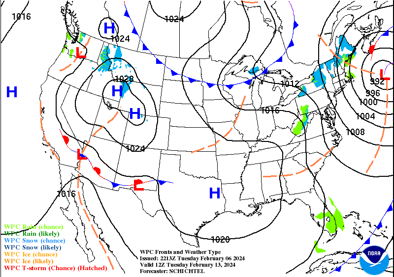
Right now high pressure remains in control over our region, while they have a wintry mix along and West of the Rockies, and some flooding and mudslides lately in California. Clear conditions in New England back through the Ohio Valley.


High pressure will move through the region tomorrow as well. And as the high pressure moves to our East, our surface winds should turn back around to the South as we get ready for our next cold front from out West, that system that has just crossed the Rocky Mountains. Tomorrow will be another sunny day, and the winds should settle down, might have a light breeze with winds up to about 10 miles per hour at times. The High should be near 63 again, and the Low should get down into the lower 30's tonight, about 33, with great conditions for radiational cooling, really dry air.
Then on Thursday, as the front approaches, clouds will be increasing, and the winds will be picking up again, a partly to mostly cloudy and breezy day. The High should be near 60, though we might not quite make it there, maybe more like 59. And the morning Low should rebound into the upper 30's, so about 38-39. Doubt we see any rain, even at night, the chance is very low, and any rain that did make it into the region should stay isolated Thursday night.

Then on Friday, we'll get enough moisture in here for some rain. The models have come into better agreement, at least for Friday. Should see a High in the lower 60's, Low in the upper 40's, with a rain chance of about 50%. When it's not raining, it'll be cloudy with a little bit of a breeze.

This front looks like a slow-mover, and rain is likely on Saturday, periods of rain showers throughout the whole day. Could see an isolated thunderstorm or two in there, as the air becomes marginally unstable, High in the mid-60's, Low in the mid-50's.

By Sunday looks like it will be safe to call the front stationary, as it hangs around and allows more waves of rain to move through the area Sunday through Sunday night. High should be more toward the lower 60's by this time, and the Low in the lower-to-mid-50's.

On Monday that low pressure system and front will be on its way out. The GFS wants to hurry it along, as usual, while the ECMWF and GEM model guidance is more gradual with it. So Monday will likely be a day of gradual clearing, with about a 40% chance of lingering showers. High in the 50's, Low in the 40's.
But since the extended period is muddled up in the model guidance, no need to try to look at ten days in advance this time. Because the information would probably be no good.


If you're looking at long-range trends though, it might be worth noting that the Climate Prediction Center expects us to turn colder than average, and also drier than average, over about the next two weeks.
And if you're watching the really cold air before it gets to moving further South later this month, Juneau, the capital of Alaska, had a cloudy and foggy day with light snow. Their High was 35 with a morning Low of 28.
There's really no way to know exactly how that cold air will affect our local weather once it does start moving. We'll likely have another cold snap to some degree before this Winter is over with, but all we can do is look at general trends, can't know specifics more than about a week in advance. And while it is never impossible for us to have wintry precipitation late in the season around here, this climate guidance suggests that the odds are against it, that we'll be cold but also the air staying pretty dry. So we'll see how it actually plays out. Please note that even if we do have another cold snap, it doesn't mean it will be as bad as the one we had in January. Temperatures being below average covers a wide range, and it doesn't always mean pipe-busting weather like that, although sometimes it can. If you're trying to sift through a lot of hype about if we'll have another rough time later this Winter, my advice is to put it out of your mind. These general trends are basically all that anyone on the planet knows.
Unless of course, those conspiracy theories about some people controlling the weather are true. Then I guess those controllers would know. But they'd be the only ones. Not even my wise kitten, Salem, is offering me any ideas on specifics of the weather beyond seven days this time. He did like the snow last month and wishes I'd let him stay out in it longer. He actually made a grand escape last night, and I had to do some fancy footwork to snatch him and get him back in. I finally got a harness on him today, going to take him for a walk, but he quickly pushed it back over his head and made it clear he had no use for such restraints. He's a character.
And in case any dimwits should stumble upon this blog, no, he doesn't really talk to me, and no, HAARP doesn't even know what kind of a rest of the winter Alabama or Tennessee is going to have.
It is tough enough to predict the weather for the next week and get the details right.
Maybe voting days bring out the worst in me. And this blog really serves little to no useful purpose anymore. But sometimes I do it anyway.

Rainfall amounts from this weekend system may be fairly significant, averaging up to about two inches for North Alabama into Southern Tennessee, also up into the Smoky Mountains and down into Central Alabama, actually into much of Mississippi and at least Northern Georgia. So that is good for our drought, but if you live in a flood-prone area, be aware that we'll have several rounds of rain over about four days in a row, most of it coming Saturday and Sunday, also when the rain is likely to be the heaviest. You can always get locally heavier amounts, even if that is isolated. Our last few rain events, we have mostly lucked out as far as any flooding issues, though some rivers did get up to flood stage at times. We did not have any serious issues with flash flooding. Maybe that luck will hold. We definitely need these to finish pulling out of our recent drought. And as we get closer to Spring time, it's always nice to get some regular rain without the strong thunderstorms that can come with them as the air is trying to turn warmer.
Thanks for reading. See you in the funny papers.
And as usual, if any native speakers have any feedback about my attempts at the Spanish translation, feel free to leave a comment. It was just something I was keen on in school and when my mother went to a church with a bunch of Mexicans and people from Central America that I wanted to talk to. Shame to let it go to waste if I'm going to waste my time throwing weather forecasts out there to begin with.
Sometimes I forget how hard this is to do right until I do it again. Perhaps I could save energy by knocking off all the sarcasm.
Decided to focus on Cullman, Walker, and Winston counties this time. Sometimes I think more in terms of all of North Alabama into Southern Middle Tennessee. Since I don't get paid for this, I experiment a lot. Sort of like a comedian who only has a tip jar I guess.
In all seriousness, if any meteorologist finds something seriously wrong, please do get in touch with me, so that I can correct it. Usually I think I keep the science pretty solid, but like I say, I'm an amateur, which used to mean someone who loves what he's doing.
And I was serious about congratulating Taylor Sarallo for being with us again.
"I shoulda' been a cowboy . . ."


No comments:
Post a Comment