

(Forecast)
Sunday (High 46, Low 44): Periods of rain showers. Overcast, cold, and breezy.
Monday (High 58, Low 37): Mostly sunny. Cool and lightly breezy.
Tuesday (High 60, Low 33): Sunny. Seasonably cold in the morning, mildly cool in the afternoon.
(Extended Outlook)
Wednesday (High 61, Low 33): Sunny.
Thursday (High 61, Low 38): Mostly sunny.
Friday (High 63, Low 49): Partly to mostly cloudy with a 40% chance of showers.
Saturday (High 62, Low 53): Partly to mostly cloudy with a 30% chance of showers.
(Pronóstico)
Domingo (Máxima 46, Mínima 44): Períodos de lluvias. Nublado, frío y ventoso.
Lunes (Máxima 58, Mínima 37): Mayormente soleado. Fresco y ligeramente ventoso.
Martes (Máxima 60, Mínima 33): Soleado. Estacionalmente frío por la mañana, ligeramente fresco por la tarde.
(Perspectiva Extendida)
Miércoles (Máxima 61, Mínima 33): Soleado.
Jueves (Máxima 61, Mínima 38): Mayormente soleado.
Viernes (Máxima 63, Mínima 49): Parcialmente a mayormente nublado con un 40 % de probabilidad de lluvias.
Sábado (Máxima 62, Mínima 53): Parcialmente a mayormente nublado con un 30 % de probabilidad de lluvias.
(Notes)
This coming week is Severe Weather Awareness Week in Alabama and Tennessee.
In Tennessee, there will also be a Severe Weather Awareness Day on February 24th, which is three weeks from today, on a Saturday. It is being held at Trevecca Nazarene University in Nashville.
In Alabama, there is Rocket City Weather Fest on the 10th, a week from today. It is held at the University of Alabama in Huntsville, and quite frankly, sometimes I miss getting to go to that thing. I went a couple years when I was in school there, and I guess I took it for granted, it being within walking distance. Seriously though, if you are interested in learning more about weather, or have somebody in your family who is, I'd recommend going if you have some free time that day and have a way to get there. It's great.
As usual, if anybody has any feedback on my attempts to do Spanish forecasts, feel free to leave a comment or otherwise get in touch, especially if you are a native speaker. Sometimes I think that's useless, but about once a week, I say "why not", sort of like trying the 10-day outlooks.
(Discussion)
As we approach the Noon hour, skies are sunny in Cullman with a temperature of 61 degrees. The dewpoint is 41, making the relative humidity 48%. Winds are from the Southeast at 9 miles per hour. The pressure is 29.94 inches and falling. Our Low this morning was 39.
Skies are also sunny in Jasper with a temperature of 64. The dewpoint-temperature is 45, making the relative humidity 49%. Winds are from the Southeast at 9 mph. The pressure is 29.91 inches and falling. Low this morning was 34. Jasper was one of the foggier spots this morning too.
It is sunny and 63 degrees in Haleyville, with a dewpoint of 44, making the relative humidity 50%. Winds are from the Southeast at 9 mph, same as the other two sites, what's up with that? The pressure is 29.93 inches/1012.8 millibars and falling. Low this morning was 37 degrees.
Elsewhere around the area, Decatur is sunny and 62 degrees. Huntsville is partly cloudy and sort of breezy, Southeast winds at 14 mph there, temperature of 61. Muscle Shoals is sunny and 64. And Nashville is partly cloudy and 58 degrees.
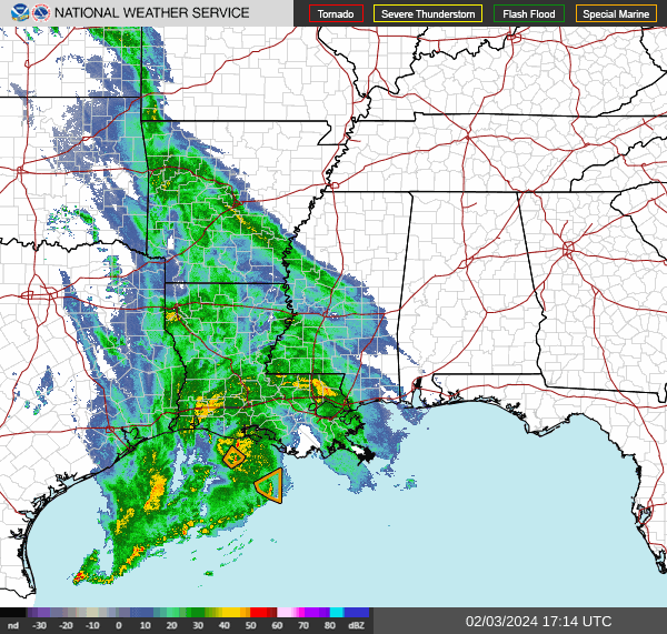


We've got a stationary front across the state of Alabama right now, but it's actually another front and low pressure system that will bring us the rain tomorrow.


Tomorrow is just going to be an overcast, cold, breezy day, with periods of rain showers throughout the day and lasting into the night hours. Temperature will hover in the 40's.
Then Monday will be mostly sunny, starting the day around 38-40 degree range, then warming to upper 50's in the afternoon, probably about 57-59. Might still have a light breeze at times, but overall winds should die down. But will still be out of the North.
Plenty of sunshine on tap for Tuesday as high pressure moves back toward the region from out in Teeeeeeeeeeeexas. High should be about 60 degrees, morning Low down in the lower 30's.


For the extended period, high pressure will dominate our weather on Wednesday and Thursday. Wednesday will be similar to Tuesday, and then on Thursday as more moist air approaches the region again, the Low should rebound into the upper 30's instead of lower 30's.
Then it's possible we could see isolated rain Thursday night, but the bulk of the rain from this next front (which may try to stall out over the region) will come Friday and Saturday, will forecast a 50% chance of rain for Friday and 40% for Saturday, since the two global models have been wishy-washy about whether or not it moves through or stalls out on Saturday and beyond. High should be in the lower 60's and Low near 50.

If I was forced to do a 10-Day-Outlook, I'd keep low-end rain chances, probably 20%, in there Sunday and Monday, with mostly sunny conditions returning by Tuesday. Keeping temperatures similar, lower 60's for the Highs, the Low in about the 46-54 range. And that's way too nitpicky to try to be specific about day by day. So I'm not doing a 10-Day this time, just a 7-Day. When even days 6-7 are not clear-cut, I don't see much point in trying for beyond that with all kinds of specifics.

Rainfall totals counting both rain events, at the beginning and end of this forecast period, should total about an inch for the Tennessee Valley. Some of the counties of Northwest Alabama might see closer to two inches, or at least in the 1-2 inch range. The forecast position of the front, which may stall out for at least one day, makes the rain look heavier there.
P.S. Had an afterthought and trimmed rain chances for next weekend back a little bit. The pattern looks unsettled, and showers may be more scattered instead of a major rain event like tomorrow's.

All this rain is really helping us pull out of the drought though.


No comments:
Post a Comment