

Thursday (High 78, Low 50): Partly to mostly cloudy. A southerly breeze.
Friday (High 70, Low 60): Rain and thunderstorms. Heavy rain is possible, and a few storms may be strong.
Saturday (High 69, Low 54): Partly cloudy. An isolated shower or thunderstorm is still possible.
Sunday (High 67, Low 48): Partly cloudy with a 20% chance of a shower/thunderstorm.
Monday (High 55, Low 40): Mostly sunny.
Tuesday (High 58, Low 30): Sunny.
Oddly enough, yesterday and today make the anniversary of the Blizzard of 1993, which a lot of people may barely remember now. But it was probably the most significant late-season snow we've ever had around here.
The National Weather Service is doing SKYWARN and Weather101 classes for the Spring season, which is our primary time of the year for severe weather around here.
The Weatherbrains podcast interviewed Harold Brooks this week, and I mean to listen to it tonight or tomorrow. Whenever you can hear one of these wise old dogs at the science talk about it, count yourself fortunate. If you're not familiar with his name, suffice to say he knows a lot about severe weather.


Tomorrow will be a lot like today, maybe a few more clouds toward the evening, sort of breezy, the High about 77-78 and the Low down around 50.
Then Friday as the front comes through, we'll have rain and thunderstorms, pretty good rain event possible here, even have to watch for isolated flooding issues, though the computer models have backed off on how likely those are.


Of course, this time of the year, the main question is whether or not we'll see any severe weather. If you believe the NAM, we really might. There is a decent combination of unstable air and wind shear when the front comes through, and if you zoom in and look at a forecast upper-air sounding up around far Northwest Alabama (somewhere between the Shoals and Corinth, MS) where the combination looks the strongest at Noon on Friday, there is moderately unstable air and plenty of wind shear, including turning of the winds at lower levels, to support large hail (quarter-sized or greater), damaging winds, or an isolated tornado.
The NAM does tend to be aggressive in showing these things sometimes.


The SREF agrees with the idea of moderately unstable air, about 1,000 j/kg of CAPE, surface-based. And the bulk shear values up to 6 kilometers, about 40 knots. But it is not even worth showing the helicity values, they are so low here. So this SREF look is more consistently with what model forecasts have been showing up to this point, where we do have to look out for a few storms with severe hail and/or damaging thunderstorm winds, but this would not be a tornado threat.

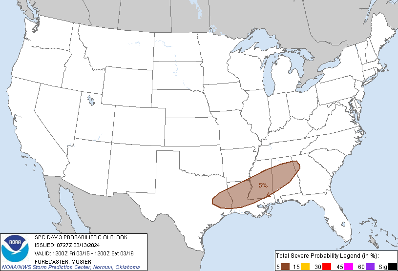
So Friday is another one of those borderline situations. The Storm Prediction Center has issued a marginal 5% risk of severe thunderstorms for at least part of North Alabama then. They'll probably adjust this tonight when they issue the new outlooks, so don't get too hung up on the exact area for now. Even if you're up across the Tennessee border, you'll need to be alert for a very low risk of some isolated stronger storms that could reach severe limits.
So basically on Friday, rain and thunderstorms, could see some stronger storms, and definitely could see some heavy rainfall. The risk of storms actually becoming severe or seeing significant flooding issues is pretty low. The High should be about 70, and the Low near 60.


Saturday keeps looking drier. We'll probably just see some clouds hanging around but also some sunshine, High near 70 again, Low in lower 50's.
Sunday we might see an isolated shower, but I'm starting to doubt even that, it may all stay to our South still. Looks like a High in the upper 60's and Low in the upper 40's.
And it wouldn't be impossible to see an isolated shower on Saturday. Might be better to just blanket both days with a minimal rain chance of 20%.


From Monday on, the high pressure moves back into the region as the front moves out of here.
We'll see a High in mid-50's Monday, Low near 40, sunshine.
Then Tuesday the High in upper 50's, Low down near 30 with the seriously drier air coming in. So we could easily see some frost again.
Then Wednesday, looks like a few clouds coming back and a warming trend beginning again, High in mid/upper 60's and Low in mid/upper 30's.

Rainfall amounts for this forecast period are now looking like they will average closer to one inch areawide, might see isolated heavier amounts.


No comments:
Post a Comment