Wednesday (High 72, Low 44): Mostly sunny. Mild.
Thursday (High 78, Low 50): Partly cloudy and lightly breezy. Isolated showers and thunderstorms are possible at night.
Friday (High 71, Low 59): Thunderstorms likely. A few storms could be strong, and rainfall may be locally heavy at times.
Saturday (High 70, Low 57): Mostly cloudy with a 20% chance of showers/thunderstorms.
Sunday (High 67, Low 54): Mostly cloudy with a 30% chance of showers/thunderstorms.
Monday (High 55, Low 40): Mostly sunny.
We had mostly sunny skies in the Tennessee Valley today, a southerly breeze at times, High of 70 in Cullman, morning Low of 34. We are back down to 57 degrees as of 9 PM with light southwest winds and a few clouds in the sky.
Our next weathermaker is the cold front bringing rain and thunderstorms to Missouri, some of those thunderstorms already reaching severe limits out that way.
Severe thunderstorms will be more organized there tomorrow and then on Thursday, a risk for severe weather will extend from the Midwest back down into Texas and Arkansas. Also a threat of flash flooding mainly focused over Arkansas on Thursday. On the back side of that front, some snow and mixed wintry precipitation is expected back in the Rocky Mountains to upper Midwest through the Great Lakes region.
We'll probably get down to about 44 degrees tonight, lower-to-mid-40's, then warm to about 72 for tomorrow's High, mostly sunny skies again. Not expecting as much of a breeze as today.
For the most part, just expecting an increase in clouds for Thursday. Might see an isolated shower or thunderstorm at night, but for the most part, the rain and storms should hold off until Friday. Even if some of it comes in really early Friday morning.
So Thursday more clouds than tomorrow, winds picking up from the South a little, a light breeze anyway. Rain chances minimal through the day, could see something at night. High climbing into upper 70's with the Low rebounding to about 50.
Then Friday we are dealing with the cold front. It looks like a good rain event, with heavy rainfall possible. No severe weather outlook is defined by the Storm Prediction Center at this point.
But the Weather Prediction Center does have us under a slight risk for excessive rainfall (that could lead to flooding issues) on Friday and then a marginal risk for Saturday.
But let's take it one day at a time. Right now we are still on Friday's weather.
But just to put things in perspective, let's backtrack and take a look at Thursday, when to our North and West, the combination of instability and wind shear is expected to be enough to cause potential for severe weather over a large part of the Midwest back into the Eastern Plains and Ark-LA-Tex region, even clipping Western Tennessee and Kentucky.
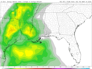
And here is the combination of instability and wind shear at midnight and then noon on Friday. It really diminishes as the system comes in here during the wee hours with a lot of rain before we have a chance for the atmosphere to destabilize during the day. At noon, the better unstable air looks to stay well to our South.
So we could see some isolated stronger storms with this sort of setup, especially this time of year, have to watch in case any try to reach severe limits. But overall the chance of any organized severe weather is looking low around here.
I'd still keep an eye on it. I have a gut feeling that someone in our region may have some problems out of this, but even if that intuition turns out to be correct, just looking at everything, looks like any such problems would be isolated in nature.
Expecting a High near 70, Low near 60 for Friday.
Saturday remains a little bit of a tossup, and the ECMWF model data was not available at this time, for some reason. The GFS has really backed off on the idea of rain up this way for Saturday. Since I can't compare the two models, just going with the WPC summary of what the weather maps are likely to look like. Looks like Saturday will likely feature mostly cloudy skies, could see isolated lingering showers, but not expecting much through the day, a High near 70 again, Low in 50's.
Then Sunday the front tries to lift Northward again to some extent, but how much is very much in question. Will bump rain chance back up to 30-40% with a High in upper 60's, Low in lower 50's.
Then for Monday and Tuesday of next week is when we see a real airmass change behind the front.
Monday will be mostly sunny with a High in the mid-50's, Low near 40.
Similar daytime temperatures for Tuesday but starting the day closer to 30, so many of us will probably be seeing frost again. We have a lot of cold snaps in March, sometimes they even last into early April.
Average rainfall totals will probably be about 1-2 inches, the higher amounts more likely in Northern Alabama than in Southern Tennessee. But of course isolated spots could see heavier amounts in any stronger showers or storms. And we could see at least a couple of those on Friday, despite the odds of severe weather being pretty low.


No comments:
Post a Comment