

FORECAST:
Sunday (High 57, Low 35): Sunny, cold, and breezy. Patchy frost is possible in the morning.
Monday (High 62, Low 31): Sunny and cool. Patchy frost is possible in the morning.
Tuesday (High 69, Low 36): Mostly sunny and mild. Patchy frost is still a possibility in the morning.
EXTENDED OUTLOOK:
Wednesday (High 72, Low 41): Partly to mostly sunny.
Thursday (High 76, Low 52): Partly to mostly cloudy.
Friday (High 72, Low 60): Rain and storms likely.
Saturday (High 67, Low 56): Decreasing clouds with a 40% chance of showers/thunderstorms.
READING TEA LEAVES:
Sunday March 17 (High 63, Low 50): Partly to mostly sunny.
Monday March 18 (High 65, Low 46): Partly to mostly sunny.
Tuesday March 19 (High 69, Low 54): Partly to mostly cloudy with a 40% chance of showers/thunderstorms.
PRONÓSTICO:
Domingo (Máxima 57, Mínima 35): Soleado, frío y ventoso. Es posible que haya heladas irregulares por la mañana.
Lunes (Máxima 62, Mínima 31): Soleado y fresco. Es posible que haya heladas irregulares por la mañana.
Martes (Máxima 69, Mínima 36): Mayormente soleado y templado. Todavía es posible que haya heladas irregulares por la mañana.
PERSPECTIVA EXTENDIDA:
Miércoles (Máxima 72, Mínima 41): Parcialmente a mayormente soleado.
Jueves (Máxima 76, Mínima 52): Parcialmente a mayormente nublado.
Viernes (Máxima 72, Mínima 60): lluvia y tormentas probables.
Sábado (Máxima 67, Mínima 56): Nubes en disminución con un 40% de probabilidad de lluvias/tormentas eléctricas.
LEYENDO LAS HOJAS DE TÉ:
Domingo 17 de Marzo (Máxima 63, Mínima 50): Parcialmente a mayormente soleado.
Lunes 18 de Marzo (Máxima 65, Mínima 46): Parcialmente o mayormente soleado.
Martes 19 de Marzo (Máxima 69, Mínima 54): Parcialmente a mayormente nublado con un 40 % de probabilidad de lluvias/tormentas eléctricas.
NOTES:
The National Weather Service is holding Weather101 as well as SKYWARN classes this month. Taking a SKYWARN class will prepare you for severe weather as well as helping us all by putting one more reliable storm spotter out there. If you can get someone else to take the class with you, all the better. These classes are free.
If you can observe weather conditions from your home, please consider joining the CoCoRaHS network. I have a really nice weather station, a Christmas gift, that I can't use because my landlord vetoed the idea. Otherwise I'd be a part of this. So if you can swing it, please help us all out with accurate local observations.
DISCUSSION:
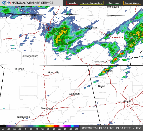


As we approach the 2 PM hour, skies are overcast in Cullman. The temperature is 59 degrees, though we were 61 just a couple hours ago. The dewpoint is 52 degrees, making the relative humidity 77%. Winds are from the Northwest at 9 miles per hour, with higher gusts to 18 mph. The pressure is 29.87 inches and steady.
It is mostly cloudy in Jasper with a temperature of 64 degrees. The dewpoint is 55 degrees, making the relative humidity 73%. Winds are from the West at 18 mph with higher gusts to 24 mph. The pressure is 29.87 inches and rising slowly.
Haleyville is overcast and 54 degrees. The dewpoint is 50, making the relative humidity 87%. Winds are Northwest at 9 mph gusting to 16 mph. The pressure is 29.91 inches/1011.9 millibars and falling slowly.
Gadsden is mostly cloudy and 58 degrees. Fort Payne is mostly cloudy and 64. Decatur is overcast and 58. Huntsville is overcast and 59. Muscle Shoals is overcast and 54. Savannah is overcast and 48 degrees. Fayetteville is overcast and 52. Winchester is also overcast and 52. And Nashville has light rain and 49 degrees.
That cold front will finish clearing the region the rest of today into tonight.


We'll get down to the mid-30's tonight. Could see a little bit of frost in the morning but overall Sunday looks sunny with a High in the upper 50's.
Monday also looks sunny but with another cold morning, Low in about the 30-32 degree range. High near 60 or so.
Then Tuesday we'll start the day in about the mid-30's, warming under sunny skies to nearly 70 degrees in the afternoon, upper 60's anyway. All three mornings, we could see patchy frost.
A few clouds return on Wednesday with a High near 70 and a Low near 40 or so as our air becomes a little more moist again.


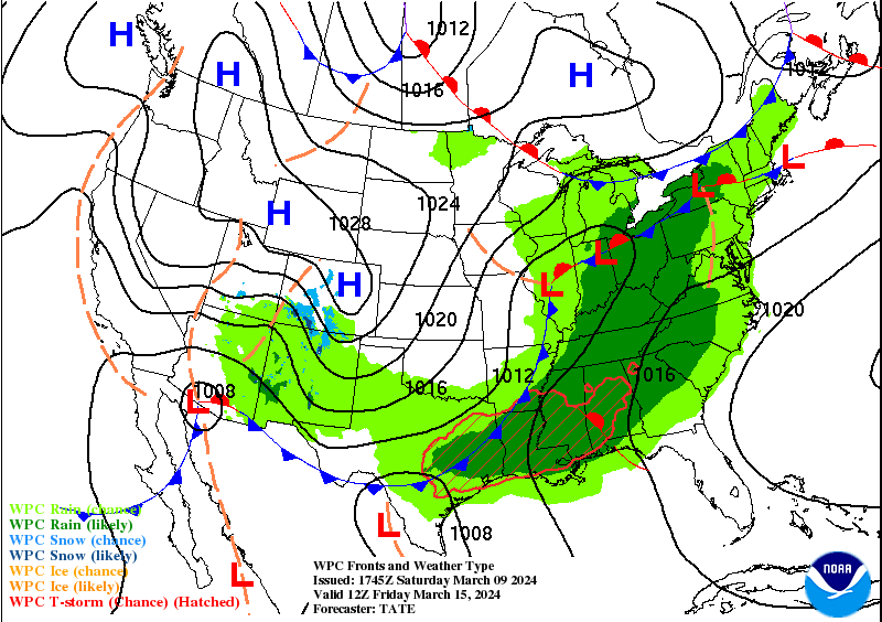


And it looks like we clear out Sunday and Monday before another system may affect us on Tuesday. Which is the 19th of March.


No comments:
Post a Comment