FORECAST:
Sunday (High 60, Low 46): Scattered lingering showers possible in the morning. Mostly sunny in the afternoon with a very cool breeze.
Monday (High 67, Low 40): Sunny. Cool.
Tuesday (High 72, Low 39): Sunny. Cool.
EXTENDED OUTLOOK:
Wednesday (High 75, Low 48): Mostly sunny.
Thursday (High 76, Low 50): Mostly sunny.
Friday (High 78, Low 57): Partly cloudy.
Saturday (High 80, Low 60): Partly cloudy with a 20% chance of showers/thunderstorms.
PRONÓSTICO:
Domingo (Máxima 60, Mínima 46): Es posible que haya lluvias dispersas y persistentes en la mañana. Mayormente soleado por la tarde con una brisa muy fresca.
Lunes (Máxima 67, Mínima 40): Soleado. Fresco.
Martes (Máxima 72, Mínima 39): soleado. Fresco.
PERSPECTIVA EXTENDIDA:
Miércoles (Máxima 75, Mínima 48): Mayormente soleado.
Jueves (Máxima 76, Mínima 50): Mayormente soleado.
Viernes (Máxima 78, Mínima 57): Parcialmente nublado.
Sábado (Máxima 80, Mínima 60): Parcialmente nublado con un 20 % de probabilidad de lluvias/tormentas eléctricas.
NOTES:
Here is a look back at weather highlights of 2023.
And here is the latest schedule of Weather101 classes. Anyone interested in the weather, of all ages, are encouraged to take one of these, as they are free and a lot of fun.
DISCUSSION:
It has been a mostly overcast and blustery day in the Tennessee Valley. Winds have shifted back to the North/Northeast. The High in Cullman was 64, and the Low this morning was 55, with humidity levels staying high. Jasper got up to 66 degrees this afternoon after a morning Low of 57. Haleyville topped out at only 61 after a Low of 53. Huntsville had a High of 67 and Low of 53 - also note they had a thunderstorm this morning. We've had a few showers and thunderstorms in the region through the day as expected. Nashville saw a High of 66 and a Low of 48 today.
That front is now stalled out down around Mobile and Biloxi, up through Georgia and the Carolinas. And we are almost done with it. Our rain is a little ahead of the previous schedule. New model data is in for the forecast, so let's look at it.
The latest run of the GFS shows the rain pretty much clear of North Alabama by 1 PM tomorrow.
The NAM shows things moving only a little more slowly.
The ECMWF is the only stickler for keeping a lot of rain around tomorrow.
I'm going to split it up with scattered showers possible up to about Noon, and then the afternoon and evening should feature mostly clear skies. Chance of rain in the morning is about 40%, ditto for overnight tonight.
Expecting a High near 60 tomorrow, Low near 45 tonight and in the morning.
High pressure quickly moves in again Monday, and by now we can safely forecast fully sunny skies, High of about 67, Low near 40. By the way, tomorrow should be breezy, but winds will calm down by Monday, only a light breeze from the North.
Tuesday will be another sunny day, starting the day near 40 again and then warming to the lower 70's in the afternoon.
A few clouds coming back into the picture but staying mostly sunny on Wednesday with a High in the mid-70's, Low in the upper 40's.
Basically the same for Thursday, Low might be closer to 50.
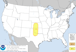
And they will have to watch for some severe thunderstorms out in the Plains of Kansas and Oklahoma, maybe parts of North Texas.
Even by Friday, it looks like while we'll see some increase in clouds, the rain stays to our North and West. We'll see a High in about the upper 70's, Low rebounding into the upper 50's.
And on Friday, the severe weather risk will shift into the Midwest, probably mostly focused on Iowa and Missouri. As we get toward the month of May, the severe weather does tend to shift more out to the Plains and Midwest. But we really aren't out of our severe weather season in the Southeast/Tennessee Valley until we get past the month of May. Especially during the first couple weeks of May, we can still have severe weather around here, as in organized spring-time type of severe weather.
Not concerned with that for this forecast period though. An upper-level ridge (seen above, top graphic, note the lines curving upward over the Southeast region) will keep that wind flow steering the storms to our North.
Having said that, we may get enough moisture Saturday from the trail of this front to see isolated showers and thunderstorms. So will introduce a 20% chance of rain.
We'll only see an average of a quarter-inch of rainfall for this forecast period, maybe isolated amounts closer to a half-inch. The rain is basically over by midday tomorrow, and then we might see something next Saturday, but even then, looks like it'll stay isolated.
Taking a break from this site indefinitely since the weather is calming down, and other things of more value require my time and energy.


.webp)


No comments:
Post a Comment