Well this weather is not wasting any time getting started this morning. May post updates here once an hour or so.
11:08 AM - Well so far the storms are staying under severe limits, you have to go up into Kentucky to find one that has gone severe. But we are about to get into the afternoon. So that is likely to change. The cloud cover may be helping us stay a little more stable, but dewpoints are still well up into the 60's, and wind shear looks to be strong this afternoon and evening. As of right now, there is a storm in Lauderdale County producing wind gusts up to 40 mph and pea sized hail. Another one tracking up in the general direction of Nashville that may be producing winds more like 50-55 mph and penny sized hail, which is just under severe criteria.
I did see where a tornado-warned storm produced some damage in West Virginia. The day is young, but the storms are forming earlier in the day than expected by a little bit. And the messy storm mode may mitigate the severe threat somewhat. But I don't want anyone to let their guard down. We should definitely treat this potential event with respect and do our best, take precautions if placed under any warnings later.
11:16 - And they are concerned about that storm intensifying as it gets toward Nashville. It is an isolated cell and could quickly produce large hail and wind damage. At this point it is not showing any signs of trying to rotate.
11:35 - There was some tornado damage in Charleston, West Virginia a while ago. Overall the storms are well-behaved, though that storm moving into Nashville may produce hail (almost severe but not quite, penny sized) and high wind gusts.
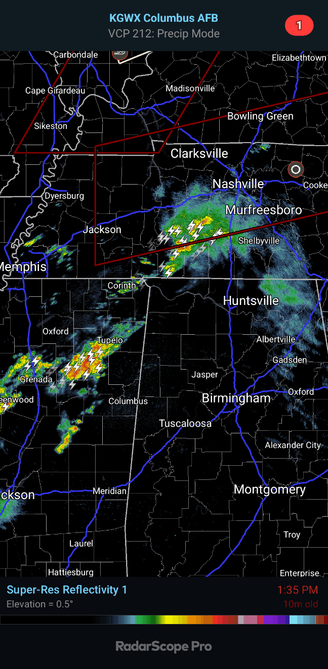
11:40 - That storm is still under severe limits but producing some hail and high winds along with the rain and lightning. Tracking up toward places like Gallatin, moving East/Northeast out of Nashville and places like Brentwood and Franklin.
The real action for us closer to home base may hold off until about mid-afternoon or so. The main event may still end up being this evening. Even in the latest SPC updates they mention how the storm mode is messy so far with this event, even up in the highest-risk areas.
11:57 - The Weather Service in Huntsville gives a very reasonable projection of how the broken line of storms will likely progress across the area this afternoon and evening. And as one of those ladies from WAAY-31 (I get the names confused sometimes) posted, if any storms become discrete supercells, the threat of a tornado will be highest with those.
And if a line just breaks up, sometimes one of those can get going. That could happen somewhere today. But you can certainly have tornadoes spin up within a squall line too. The greater threat is damaging winds and large hail, but the risk of a few isolated tornadoes in the region is fairly significant too. The cloud cover and earlier timing may be helping us out some, but I'd still be prepared for whatever storms do go severe. I'm glad if the threat can be diminished some by mesoscale details like that, but the threat is still there. And we may get a low-level jet this evening that will help us destabilize more anyway.

12:05 PM - Taking the wide view, you can see first of all, the severe activity is starting to uptick in Kentucky, which is expected. But down this way, things are pretty quiet overall. You can see that a broadly defined squall line is trying to form in Central Mississippi. That should get to the Shoals about 3 or 4 PM. And at that point, we will have to watch things again, for thunderstorms becoming severe within the line or especially any storms that might become isolated. Damaging winds, large hail, isolated tornadoes are possible this afternoon and evening. And we definitely can't rule out somebody getting some significant storm damage with this setup. It could happen. Going to log off for a while, while there is a lull.
12:23 -
Ryan Hall is streaming from Kentucky, and I thought it was neat how he showed his tornado shelter outside. Surprised to learn that he doesn't have any interior rooms in his house, but glad he has the shelter. The kind he uses is called Survive-a-Storm. It is an above-ground type of shelter, and he said it costs as much as a washer and dryer.
12:58 - Man, look at those thunderclouds on satellite.
1:03 PM - The storms are trying to get more organized in a line in Mississippi.
And then as those storms track up into Tennessee, people up that way will want to watch them closely, especially around Nashville and points North and East. But basically all of Middle Tennessee is under a Tornado Watch already. So have to watch any storms closely in case they try to become severe.
1:14 - They did have some large trees uprooted in Oak Hill, TN near an elementary school a bit south of Nashville earlier with that heavy storm that came through. No injuries or anything. The weather service offices are likely going to save their warning trigger fingers for the storms thought to be directly life-threatening on a day like today, not a borderline storm like that was. Some strong storms are back in Mississippi where a squall line is slowly trying to form. They are still under severe limits for now.
1:27 - Here is
a list of public shelters across Tennessee. For people who live in mobile homes especially these can be so important to know about. And there are not as many shelters in Tennessee. But I think that trend is changing over time.
1:46 - As we are nearly to the two o' clock hour, we only have general thunderstorms in the region. Sometimes these things take a while to get going. Even up in the Ohio Valley, they are still in the calm before the storms for the most part.
We do have a long afternoon and evening ahead of us. Some of the storms may last into the dark hours, especially in Northeast Alabama. Looks like a broken squall line will try to form, but the storm mode with this sure looks messy, like a mix of storm modes. Definitely still potential for damaging winds, large hail, and a few tornadoes across the region later today into tonight. Dewpoints are well up into the 60's, and some of the better wind shear is working into Northwest Alabama now.
1:53 - I guess it wouldn't be my commentary without a grouchy note somewhere. Gotta' love how Bill Maher and J.K. Rowling are trending on social media even when much of the country is bracing for a severe weather outbreak. People's priorities just . . . so . . . rock. (Sarcasm ad nauseum.)
2:22 PM - For anybody who has paid attention to the forecast soundings in my discussions, here is one in real-time. These are the actual conditions in Nashville from their special extra balloon launch. It shows moderately unstable air and very strong wind shear, including that low-level helicity needed for tornadoes to form. The atmosphere does not appear to be capped either, no warm-layer inversion up there to be eroded.
We have CAPE at surface just under 1,000 joules but Helicity over 400 units at 3 km and way more than enough for tornadoes down at 1 km too. STP value is a 3, significant tornado parameter, supercell composite is kind of up there too. It occurred to me I rarely show the real things, just what they are forecast to be. So showing this one.
2:26 - It is 81 degrees in Jasper, dewpoint of 66. I believe it's Scottsboro also at 79 degrees, close enough, 77 in Huntsville. The atmosphere is primed for some storms that develop or move in later to become severe, that's for sure. It is kind of a messy setup, but the potential for severe storms is real. They will issue another Tornado Watch to replace that one that expires at 3 PM.
Made a mistake about supercell composite, that was something I was remembering from a forecast graphic somebody posted along with the actual sounding here, which did not show that parameter.
2:36 - We do have some thunderstorms moving into Northwest Alabama now, but at this point, showing no signs of being severe. Remember that things can ramp up quickly on a day like today. But for now these are just regular thunderstorms.
2:40 - I think I grabbed the wrong graphic above for the Nashville sounding. Here is the real one, directly from their weather forecast office, they posted.
And the Huntsville office is closely monitoring these storms moving in. The Nashville office is watching everything even more closely I think, because their environment is very ripe for storms to rotate. We also just got something new from SPC about extending the Tornado Watch to maybe include Northwest Alabama.
.png)
3 PM - They are planning to reissue the Tornado Watch, but they make mention of how Mississippi is really the only place where enough destabilization of the air, the overall thermodynamic profiles, have been enough to go with the strong wind shear so that storms are starting to intensify. The clouds and earlier convection have indeed helped us out some, like I was thinking earlier this morning, but started to doubt since the air has gotten somewhat unstable anyway. They basically are saying that the threat continues, for severe thunderstorms and tornadoes, but that instability is the limiting factor so far, and we'll just have to watch and see how that plays out. But they do plan to reissue the Tornado Watch and may include some of Northwest Alabama this time. That activity coming out of Mississippi is the main concern right now. If it stays mostly under severe limits, I personally would love that, but we have to be prepared for the possibility that some of it may become severe. We have several hours to go with this event where the potential is there.
SEL5
URGENT - IMMEDIATE BROADCAST REQUESTED
Tornado Watch Number 75
NWS Storm Prediction Center Norman OK
950 AM CDT Tue Apr 2 2024
The NWS Storm Prediction Center has issued a
* Tornado Watch for portions of
Southern Kentucky
Western and middle Tennessee
* Effective this Tuesday morning and afternoon from 950 AM until
300 PM CDT.
* Primary threats include...
A few tornadoes likely with a couple intense tornadoes possible
Widespread damaging winds and isolated significant gusts to 75
mph likely
Scattered large hail events to 1.5 inches in diameter likely
SUMMARY...A loose cluster of storms in western Tennessee is expected
to evolve into a couple of supercells while spreading
east-northeastward toward southern Kentucky and middle Tennessee
through midday and early afternoon. The environment ahead of the
storms will be favorable for tornadoes, a couple of which could be
strong (roughly EF2), as well as damaging gusts up to 75 mph and
large hail of 1-1.5 inches in diameter.
The tornado watch area is approximately along and 50 statute miles
north and south of a line from 20 miles north of Jackson TN to 45
miles north of Crossville TN. For a complete depiction of the watch
see the associated watch outline update (WOUS64 KWNS WOU5).
PRECAUTIONARY/PREPAREDNESS ACTIONS...
REMEMBER...A Tornado Watch means conditions are favorable for
tornadoes and severe thunderstorms in and close to the watch
area. Persons in these areas should be on the lookout for
threatening weather conditions and listen for later statements
and possible warnings.
&&
OTHER WATCH INFORMATION...CONTINUE...WW 73...WW 74...
AVIATION...Tornadoes and a few severe thunderstorms with hail
surface and aloft to 1.5 inches. Extreme turbulence and surface wind
gusts to 65 knots. A few cumulonimbi with maximum tops to 500. Mean
storm motion vector 24050.
...Thompson
WOUS64 KWNS 021448
WOU5
BULLETIN - IMMEDIATE BROADCAST REQUESTED
TORNADO WATCH OUTLINE UPDATE FOR WT 75
NWS STORM PREDICTION CENTER NORMAN OK
950 AM CDT TUE APR 2 2024
TORNADO WATCH 75 IS IN EFFECT UNTIL 300 PM CDT FOR THE
FOLLOWING LOCATIONS
KYC001-003-009-035-045-047-053-057-087-099-137-141-169-171-207-
213-217-219-221-227-022000-
/O.NEW.KWNS.TO.A.0075.240402T1450Z-240402T2000Z/
KY
. KENTUCKY COUNTIES INCLUDED ARE
ADAIR ALLEN BARREN
CALLOWAY CASEY CHRISTIAN
CLINTON CUMBERLAND GREEN
HART LINCOLN LOGAN
METCALFE MONROE RUSSELL
SIMPSON TAYLOR TODD
TRIGG WARREN
TNC003-005-015-017-021-023-027-031-035-037-039-041-043-049-055-
061-071-077-079-081-083-085-087-099-101-109-111-117-119-125-133-
135-137-141-147-149-159-161-165-169-175-177-181-183-185-187-189-
022000-
/O.NEW.KWNS.TO.A.0075.240402T1450Z-240402T2000Z/
TN
. TENNESSEE COUNTIES INCLUDED ARE
BEDFORD BENTON CANNON
CARROLL CHEATHAM CHESTER
CLAY COFFEE CUMBERLAND
DAVIDSON DECATUR DE KALB
DICKSON FENTRESS GILES
GRUNDY HARDIN HENDERSON
HENRY HICKMAN HOUSTON
HUMPHREYS JACKSON LAWRENCE
LEWIS MACON MARSHALL
MAURY MCNAIRY MONTGOMERY
OVERTON PERRY PICKETT
PUTNAM ROBERTSON RUTHERFORD
SMITH STEWART SUMNER
TROUSDALE VAN BUREN WARREN
WAYNE WEAKLEY WHITE
WILLIAMSON WILSON
ATTN...WFO...LMK...OHX...MEG...PAH...


.png)


No comments:
Post a Comment