Wednesday (High 72, Low 58): Rain and thunderstorms likely. Rain may be heavy at times, and some storms could produce strong winds, approaching severe limits.
Thursday (High 66, Low 55): Partly to mostly cloudy and breezy. Scattered lingering showers and thunderstorms are possible.
Friday (High 67, Low 45): Mostly sunny. Cool and breezy.
Saturday (High 76, Low 43): Sunny.
Sunday (High 80, Low 48): Sunny.
Monday (High 81, Low 56): Mostly sunny.
Tuesday (High 83, Low 61): Partly cloudy.
As we approach 3 PM skies are mostly cloudy in Cullman. The temperature is 57 degrees. The dewpoint is also 57, making the relative humidity 100%. Winds are out of the Southeast at 8 miles per hour, with gusts up to 14 mph. The barometric pressure is 30.08 inches and falling. Visibility is 10 miles.
Jasper is overcast and 59 degrees, also a relative humidity of 100% there. Winds are out of the Southeast at 7 mph. The pressure is 30.07 inches and falling.
We have perfect visibility at all three of these sites, but Haleyville is also overcast. It is 58 degrees, same dewpoint, 100% relative humidity. Winds are SE at 13 mph, gusting to 17 mph. The pressure is 30.07 inches/1017.3 millibars and falling.
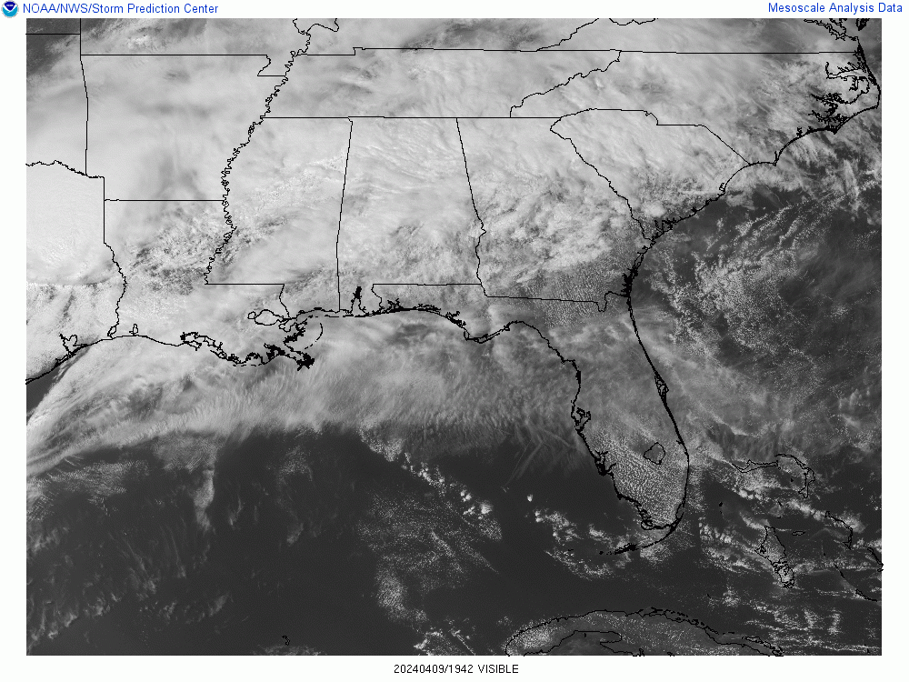
We basically have a mass of rain moving through the region today ahead of a low pressure system centered out in Texas, a few thunderstorms in the mix. Areas to our West do have some risk of severe thunderstorms today.
The big weather news that brought me back here a day or two early is that the Storm Prediction Center has outlooked a part of the Southeast region for a Moderate Level 4/5 Risk for severe thunderstorms tomorrow.
It's important to understand that this does not affect North Alabama or up into Tennessee. But down there along the Gulf Coast, mainly in Southern Mississippi, but also including much of far Southwest Alabama, some risk for widespread damaging winds and tornadoes is expected.
Up this way, we only have the basic level 2/5 risk for severe thunderstorms, the main threat being damaging wind gusts, only the basic 15% risk for that around here. And as you get up into Tennessee, the risk drops off to 5% which is in the marginal level 1/5 category.
We will have to keep an eye on things tomorrow, but I think our greater threat would be for isolated instances of flash flooding. I personally think if we see any severe thunderstorms, that will stay isolated. The storm mode is just too messy. Expecting a High of about 72-73, morning Low of about 58-59.
Then on Thursday, that front will be slowly moving out of the region. We'll have scattered lingering showers and thunderstorms. If we were to see any become severe, I think it'd be limited to Northeast Alabama, or maybe around places like Winchester in Tennessee. The SPC does have marginal severe thunderstorm probabilities for those areas on Thursday, but I don't feel like they are worth posting here. I think our local severe weather threat is going to play out as even less than what they are outlooking. Expecting a High more toward the mid-60's Thursday and mid-50's for the Low.
We'll be high and dry again by Friday. We'll see mostly sunny skies, a High in the upper 60's, the Low in the mid-40's. We're not going to see another freeze this season, doubt we see any more frost either. Probably no more of that until about October or November. We'll still be breezy on Friday though, so that will make it seem colder, at least in the morning.
Then Saturday with high pressure strongly centered over the Southeast we'll see sunny skies, the Low in the mid-40's but maybe even dipping into lower 40's with good radiational cooling, the High in mid-70's but maybe edging into upper 70's. Great day if you need to get something done outside that you've been putting off, if you are fortunate enough to have the day off work. For many, this is the day they actually work the hardest. So don't believe the stereotypes . . .
On Sunday that high pressure will be moving off to the East but still in control of our weather, so plenty of sunshine, a High near 80, Low near 50 or at least upper 40's. Air will stay really dry during this period, so great radiational cooling conditions overnight.
Then we could see a few clouds come back by Monday, but overall a mostly sunny day, High near 80 again, Low rebounding to about the mid-50's.
Then by next Tuesday, we have our next weather system centered out in Nebraska, not close enough to bring us any rain yet, but enough to bring some clouds back to the forecast, a High in the lower 80's and a Low rebounding to about 60 degrees.
I started to show model guidance for tomorrow's severe weather potential, but it is such a big mess that it doesn't feel worth it. The NAM is showing a later timing so that it's basically and overnight event into Thursday morning. And even there, the parameters are looking marginal overall for severe weather. So just going to throw in a reminder of the SPC forecast.
As for the really organized threat for significant severe weather tomorrow, it is focused from about Mobile and Biloxi up to about Jackson, MS.
Aroun here, we have that 15% basic risk for damaging thunderstorm winds, a few of us in the far Northeast only have the marginal 5% probability.
The threat for large hail with this system is not expected to be much at all since the unstable air is expected to be lacking. The strong wind dynamics are expected to be able to overcome this, although like I said above, I remain skeptical, like if this threat really plays out in the Tennessee Valley, I think any instances of severe will stay pretty isolated. If I was drawing the maps, I'd put us all in North Alabama under the same marginal threat levels as they have well up into Tennessee.

This 5% tornado risk is your typical risk for isolated tornadoes that you see with many severe weather events this time of year. Notice almost all of Tennessee and parts of Northeast Alabama are only under the 2% minimal tornado potential. My personal opinion is that this is going to be a minimal-threat event for all of us in North Alabama. And I agree with the SPC outlook for Tennessee counties. Even for damaging winds, I think the threat is likely to stay isolated around here. I'm showing you what the experts say but also admitting my personal opinion, which is that our threat for any organized severe weather up here is going to turn out to be very low, even lower than what these official maps show.


I'm a little more concerned about the potential for flooding issues on some roads or more likely around bodies of water through tomorrow, maybe early part of Thursday. And even that will probably stay isolated. But it is more plausible with this synoptic weather setup than an organized threat for severe thunderstorms.
Average rainfall totals over the next seven days should be between about 1-3 inches. Lowest totals probably on the Tennessee side, highest totals probably in Northwest/West Central Alabama.


No comments:
Post a Comment