

FORECAST:
Friday (High 67, Low 44): Sunny. Cool and breezy.
Saturday (High 76, Low 43): Sunny. Mild.
Sunday (High 80, Low 49): Sunny. Warm.
EXTENDED OUTLOOK:
Monday (High 81, Low 53): Mostly sunny.
Tuesday (High 83, Low 58): Partly cloudy.
Wednesday (High 82, Low 63): Partly to mostly cloudy with a 20% chance of showers/thunderstorms.
Thursday (High 83, Low 62): Partly cloudy.
PRONÓSTICO:
Viernes (Máxima 67, Mínima 44): Soleado. Fresco y ventoso.
Sábado (Máxima 76, Mínima 43): Soleado. Leve.
Domingo (Máxima 80, Mínima 49): Soleado. Cálido.
PERSPECTIVA EXTENDIDA:
Lunes (Máxima 81, Mínima 53): Mayormente soleado.
Martes (Máxima 83, Mínima 58): Parcialmente nublado.
Miércoles (Máxima 82, Mínima 63): Parcialmente a mayormente nublado con un 20 % de probabilidad de lluvias/tormentas eléctricas.
Jueves (Máxima 83, Mínima 62): Parcialmente nublado.
NOTES:
We recently had the 50-year-anniversary of the April 3-4, 1974 tornado outbreak.
The Weatherbrains podcast had a couple good shows about that, then this past Monday, did a home-grown show that covered several good subjects. One was about how the National Weather Service in Birmingham has done a lot of local research since the April 2011 tornado outbreak to maximize their Probability of Detection and minimize their False Alarm Ratio for warnings.
And the National Weather Service in Nashville is still doing Weather101 classes on a variety of subjects. If you're curious, take one; if you like it, spread the word.
DISCUSSION:


As we approach 3 PM, skies and the air are foggy and misty in Cullman. The temperature is 57 degrees. The dewpoint is also 57 degrees, making the relative humidity 100%. Winds are from the Southwest at 7 miles per hour, with higher gusts to 15 mph. The barometric pressure is 29.55 inches and rising slowly. The visibility is currently down to 6 miles, and within the past hour, got down to 1.75 miles. So take it easy driving out there. Our High today was 68, and our current temperature of 57 is our Low so far. Since the temperatures are going backwards today, everything's messy, just going to give current conditions for a few other sites, not bother with the High and Low. Overall we've had a foggy/misty/cloudy day with a little bit of a breeze left and periods of light rain across the Tennessee Valley.
It is foggy and misty in Jasper with a temperature of 59 degrees. Also have 100% relative humidity there. Winds are West at 17 mph with gusts to 28 mph. The pressure is 29.58 inches (in case you noticed, yes, that's really low) and rising. The visibility is down to 2 miles. So again, driving may be precarious, especially on that four-lane that used to be Highway 78 and has been Highway 118 for a considerable long stretch of years now. I might even avoid that four-lane and take some backroads on a day like this.
It is rainy and foggy in Haleyville with a temperature of 56. Once again, humidity is 100%. Winds are Northwest at 9 mph with gusts up to 17. The pressure is 29.59 inches/1000.8 millibars and rising. The visibility is down to 2 miles. The visibility is so poor you'd almost think it was foggy behind a cold front or somethin'.
We have light rain and fog in Huntsville with a temperature of 62 degrees, visibility down to 4 miles. It is overcast in Nashville with a temperature of 59 degrees, and perfect visibility of 10 miles once you get up there to the Music City.
So the rain moving through our area right now is basically along and ahead of a reinforcing cold front. We are under a wind advisory while this system finishes moving through the region. Winds could gust up to about 30-40 mph.


The last of the rain should clear out overnight, and the winds will gradually die down, though we could still be breezy many times through the night, with gusts between 10-20 mph. Much of the night may be clear, and certainly tomorrow is expected to have little to no cloud cover, with strong Northwest upper-level wind flow and high pressure moving in from the Southwest at the surface. The High should be near 67, and the Low tonight/tomorrow morning should be near 44. These forecasts are for Cullman, so of course if you're slightly to the North or South or in different elevations, the approximate temperatures are always going to vary a little bit. Even across Cullman County, it can vary if you're down at Smith Lake versus if you're in downtown versus if you're in Vinemont or Hanceville, or up along the Morgan County line. I usually expect people understand this on their own, but for some reason, today I'm explaining it. The winds may still gust up to 20 mph or even 30 mph at times, definitely a cool and breezy day.


Then on Saturday, sunny skies again, winds should have settled down as the high pressure is firmly in charge of our weather, centered in the Gulf of Mexico. Winds should be from the West at about 5-10 mph. High should be in the mid-70's, could edge into upper 70's, so about 76-77, and the Low keeps trending toward the lower 40's via model guidance, so probably 44-43.


Weather patterns stay dynamic in April, and this high pressure system wont' stay still. But we'll stay sunny on Sunday with a High near 80 and Low near 50 as it moves along.
Next week is looking to be the warmest we've been so far this year.
And by the way, you can go ahead and plant any sensitive crops. We might have another cool snap behind a storm system between now and May, but the chance of any kind of freeze again this season is too low to even worry about. For the most part, we're done with the cold weather until about October or November.


On Monday we come under an upper-level ridge, and the high pressure system starts to move further off to the Southeast, into Florida. We will stay mostly sunny, with a High near 80 and a Low in the lower 50's. Don't think we see enough moisture return for mid-50's yet.


On Tuesday our next cold front will remain West of our region. I doubt most of us see any rain at all, even at night. If we do, should stay very isolated across the region, more likely to see that in the Western counties, if we see any at all. We'll see more clouds around on Tuesday and a High in the lower 80's, Low rebounding to the upper 50's, most of us probably will not see 60 degrees again yet.

Tuesday might feature organized severe weather our in the Plains with this system. And people on the fringes of the Midwest will have to watch it too. The hot spot looks to be in Oklahoma based on the forecast track of the low pressure center and various parameters.


On Wednesday we'll be affected by that front in the TN Valley.

Although the actual front is expected to stay way back to our Northwest, basically back in the Midwest. We'll be getting rain well in advance of it.
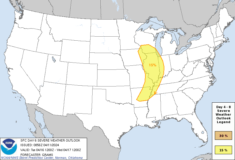
The risk for any organized severe thunderstorms is expected to stay up in places like Memphis up through Chicago up to Southern Wisconsin. At the moment, nothing points to severe thunderstorms around here.
And that's important to tell people sometimes. Just as you need to know when the weather is serious, if we've got a system in April, the heart of tornado season, that doesn't look like it poses any serious threat, that can be important to know too. That's why I made a point of saying that the severe weather threat with this last system was going to be very low.

And sure enough, the severe weather stayed well to our South yesterday. It's important to let people know sometimes to chill out, it's not that big a deal. If every little bird-fart thunderstorm sounds like the four horsemen saddling up, as Chuck Doswell used to joke, then what are people going to do when it really is a terrible tornado outbreak . . . he used the example of May 3, 1999 out in the Plains. Here in the Southeast, I can think of several bad tornado outbreaks over the years, but of course April 27, 2011 was the worst one in my lifetime. But there was one the year before, the day Yazoo City, MS got hit so hard, that was bad enough. That was also the event where Albertville got hit really hard. There was a long lull that day where people wondered if it was going to be a bust for North Alabama, but then as it got into Northeast Alabama, things just exploded with several powerful tornadoes. On a day like that, people need to know it's serious business. But you might only see two or three days like that in an average year. Not every severe weather threat deserves to be hit that hard in the forecasting.
Seems like I got sidetracked from the regular forecast. Wednesday looks like a mostly cloudy day with a High near 80 or so again, the Low in the lower 60's. Rain chances should stay about 20-30% . . . isolated rain and thunderstorms. This time of year it's hard to rule out a stronger storm somewhere, but this is not a severe weather look at all for right around here. The SPC keeps the risk well to our West.


Just in the interest of being thorough, looking at what the GFS shows for parameters. The Energy Helicity Index does barely get up to levels enough to be concerned about on Wednesday evening. Though most of the hot zones are still well to our North and West.

But even in Northeast Mississippi, the risk appears marginal for even large hail and damaging thunderstorm winds. This is not a tornado setup look, either by these smaller-scale parameters (tough to forecast this far in advance, but these models give us some basic idea) or by the overall synoptic setup.


Tough call, but may keep a 20% chance of rain in for next Thursday. Although even putting that much rain chance in for Wednesday is kind of a toss-up by itself. The High should be in the lower 80's and Low in the lower 60's.
Then the guidance for next weekend is so murky that it's not worth trying to do a 10-Day-Outlook.

Rainfall amounts should be very light for this forecast period, generally under one tenth of an inch of rainfall.


No comments:
Post a Comment