

FORECAST:
Sunday (High 80, Low 50): Mostly sunny. Low humidity.
Monday (High 82, Low 54): Mostly sunny. Cool in the morning, warm in the afternoon.
Tuesday (High 81, Low 59): Partly to mostly cloudy. Widely scattered showers/thunderstorms are possible at night.
EXTENDED OUTLOOK:
Wednesday (High 78, Low 62): Mostly cloudy with a 40% chance of showers/thunderstorms.
Thursday (High 80, Low 61): Partly to mostly cloudy with a 30% chance of showers/thunderstorms.
Friday (High 74, Low 58): Partly to mostly cloudy with a 20% chance of lingering showers.
PRONÓSTICO:
Domingo (Máxima 80, Mínima 50): Mayormente soleado. Baja humedad.
Lunes (Máxima 82, Mínima 54): Mayormente soleado. Fresco por la mañana, cálido por la tarde.
Martes (Máxima 81, Mínima 59): Parcialmente a mayormente nublado. Por la noche son posibles chubascos muy dispersos.
PERSPECTIVA EXTENDIDA:
Miércoles (Máxima 78, Mínima 62): Mayormente nublado con un 40 % de probabilidad de lluvias/tormentas eléctricas.
Jueves (Máxima 80, Mínima 61): Parcialmente a mayormente nublado con un 30% de probabilidad de lluvias/tormentas eléctricas.
Viernes (Máxima 74, Mínima 58): Parcialmente a mayormente nublado con un 20 % de probabilidad de lluvias persistentes.
Sábado (Máxima 70, Mínima 50): Parcialmente a mayormente soleado.


It has been a sunny day in the Tennessee Valley, breezy at times, really low humidity levels. The High in Cullman was 77 after a morning Low of 41. Jasper saw a High of 81 this evening after a morning Low of 37. And Haleyville got up to 79 after a morning Low of 39. Peeking up to our neighbors to get an idea of how things are up closer to the Tennessee state line, Huntsville saw lighter winds overall today and a few more fair-weather clouds, a High of 77 and Low of 42.


Tomorrow the high pressure system will start to move Southeast, and our upper-level wind flow will become more zonal (from the West). But we will stay mostly sunny with a High near 80 and Low near 50.


Monday looks similar around here, with a High of 80 or so, the Low near 53-54.
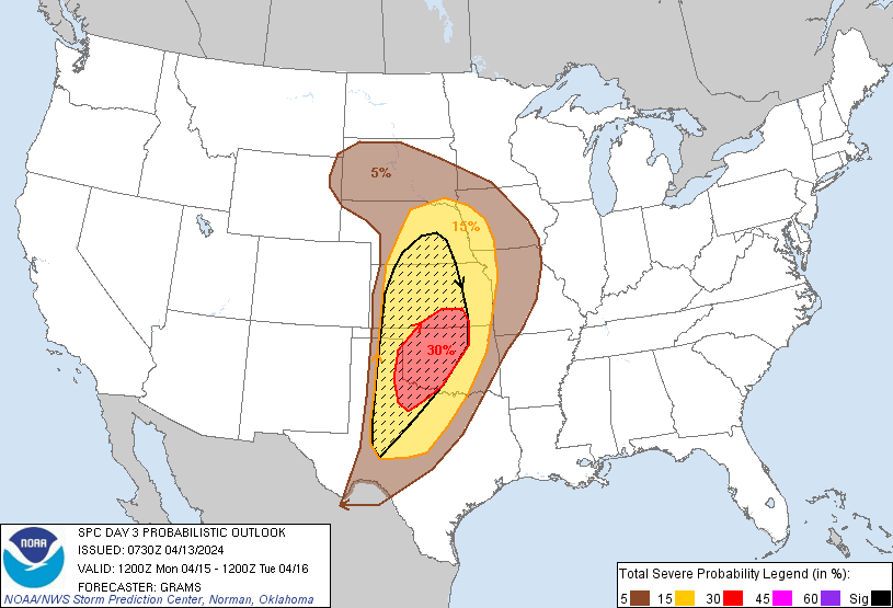
Out in the Plains, they do have a risk for organized severe weather on Monday, some of which may be significant, with supercell thunderstorms a good possibility out there, especially in that area the SPC has hatched.


We'll see an increase in clouds on Tuesday. We might see some rain move in at night, but even if so, would probably stay scattered across the region. The day is still expected to be dry. But we'll see more clouds than sun overall. The High should get to about 80, and the Low should rebound to nearly 60, upper 50's.


Then on Wednesday we do have to bump up the rain chances from the forecast a couple days ago. Still only looks like a rain chance of 40-50% around here.

And notice how far away we are from the parent Low with this weather system. If we see severe weather probabilities introduced for Wednesday, they will likely be focused over the Ohio River Valley to our North.

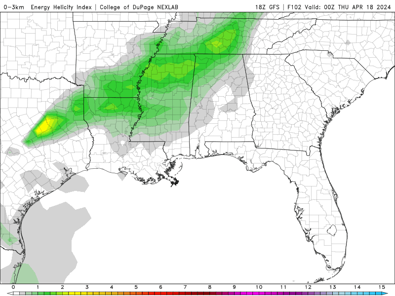

But since it is April in the Southeast/TN Valley, let's double-check. And the best combination of unstable air and wind shear looks to stay to our Northwest for the most part. At sundown, the parameters around here are marginal for any thunderstorms to reach severe limits, even with damaging wind gusts. At least according to what the GFS is showing us right now. And this just looks like an event where if there is severe weather continuing with it on Wednesday, it will probably stay to our North/Northwest, not be an issue for much if any of North Alabama.
So Wednesday should feature a High in the upper 70's, Low around 60 or so. At least a 40% chance of showers/thunderstorms, maybe more like 50%. Will review that after looking at each day, look at the overall pattern and best estimate for rain chances.


Then on Thursday the rain chance drops to 20-30%. Expecting a High near 80, Low near 60.

It's kind of an odd setup where we'll have one cold front clear of the region but another on the way.


The forecast stays messy next Friday. The GFS is slower in bringing us another round of rain.

While the ECMWF brings it on through.
For now a good estimate seems to be a 30% chance of rain for Friday, High temperature dropping back to mid-70's, Low staying in upper 50's. Likely to be an overcast day with some breaks in the clouds at times.


Then Saturday the GFS wants to bring that system on in a day later than the ECMWF.

Which has us clearing up on Saturday.
My personal experience is that the European model is usually closer to getting it right in systems like this, this time of year. Probably neither global model is nailing this down exactly.


Can always default to the WPC graphics if you want a simpler view of the overall pattern. We should see a clearing, cooling trend Friday into Saturday. The only disagreement between the models is how fast it happens.
Here's what I think as far as rain chances. For Tuesday, probably shouldn't even include a 20% chance unless it is at night. And then 30% might be more accurate, in case some showers do creep in here early. The main rain chance this next week is going to be Wednesday, and I'm just going to forecast 40% chance there, scattered rain. Then back to 30% - widely scattered - for Thursday. Then Friday I'll keep a 20% chance in. And then drop the rain chances for next Saturday.
By a week from today, we should see a High near 70, Low near 50 behind that front.

Average rainfall totals around here should be half an inch or less for the next week.


No comments:
Post a Comment