

FORECAST:
Sunday (High 82, Low 60): Mostly sunny. Warm and breezy.
Monday (High 81, Low 61): Partly cloudy and breezy with isolated showers and thunderstorms possible during the day. Rain showers may become more numerous at night.
Tuesday (High 80, Low 60): Partly to mostly cloudy. Isolated showers and thunderstorms are still possible.
EXTENDED OUTLOOK:
Wednesday (High 84, Low 59): Mostly sunny with a 20% chance of a shower or thunderstorm.
Thursday (High 86, Low 61): Mostly sunny with a 20% chance of a shower or thunderstorm.
Friday (High 83, Low 62): Partly cloudy with a 30% chance of showers/thunderstorms.
PRONÓSTICO:
Domingo (Máxima 82, Mínima 60): Mayormente soleado. Cálido y ventoso.
Lunes (Máxima 81, Mínima 61): Parcialmente nublado y ventoso, con lluvias aisladas y tormentas eléctricas posibles durante el día. Los chubascos pueden volverse más numerosas por la noche.
Martes (Máxima 80, Mínima 60): Parcialmente o mayormente nublado. Aún son posibles lluvias y tormentas aisladas.
PERSPECTIVA EXTENDIDA:
Miércoles (Máxima 84, Mínima 59): Mayormente soleado con un 20 % de probabilidad de lluvia o tormenta eléctrica.
Jueves (máxima 86, mínima 61): Mayormente soleado con un 20 % de probabilidad de lluvia o tormenta eléctrica.
Viernes (Máxima 83, Mínima 62): Parcialmente nublado con un 30% de probabilidad de lluvias/tormentas eléctricas.
Sábado (Máxima 80, Mínima 63): Parcialmente a mayormente nublado con un 40% de probabilidad de lluvias/tormentas eléctricas.
NOTES:
Today is the anniversary of one of the worst tornado outbreaks we've ever had to deal with. There is all kinds of good information at that link. If you want to do a deeper dive into that event, I'd recommend reading What Stands in a Storm by Kim Cross and All You Can Do Is Pray by James Spann.
And here is a look back at weather highlights from last year.


It has been a mostly sunny and breezy day in the Tennessee Valley. The High in Cullman was 79 with a morning Low of 66. Our winds have generally been out of the South/Southeast, gusting to about 20 miles per hour at times. Jasper got up to 84 today after a morning Low of 59. Haleyville saw a High of 82, Low of 62 today. Huntsville saw a little more cloud cover hanging around, High of 83, Low of 67. Ditto on the cloud cover but still staying warm for Nashville, the Music City seeing a High of 82 after a morning Low of 67.
Our weather is calm thanks to that pronounced ridge of high pressure we've had over the Southeast/TN Valley for quite some time now. Currently centered over the Carolinas. It is the Midwest and Plains getting the kind of weather that we normally would this time of year. Night now the hot zone appears to be from Eastern Kansas up into adjacent parts of Missouri.

Yesterday was a horrible tornado outbreak for mainly Nebraska and Iowa, though they also had some issues in Eastern Kansas and Missouri, also some in Texas, and some damaging winds as far East as Arkansas. The final tornado tally looks to be in about the 80-100 range. A lot of these tornadoes were that wedge or stove-pipe form that often do the most damage. And a few did level entire houses. But as of this writing, only one serious injury has been reported. Even watching this from a distance, I have found myself taken aback. If the outcome stays that good, then we need to study this event, what went so much better than things went for the Southeast in 2011 this time of year. Because we had about 300 people killed in the event, which featured about 60 or so tornadoes, many of them taking just about everything in their path. I don't know how this event yesterday will stack up historically, but that one part of Nebraska and Iowa sure did have the ideal conditions for just one supercell thunderstorm after another to produce a tornado. As far as I know as I write this on Saturday evening, nobody was killed in these tornadoes. And that blows my mind. I do remember before the 2011 event here, Davis Nolan posted about how an F-4 had hit somewhere in Arkansas from the same storm system a night or two before, and everybody made it out okay. He was hoping for similar things when the system affected us. Of course there are differences. We don't know the ratings for these tornadoes yet, but some will have to be rated at least F-3 (or EF-3 if you prefer the extra letter). Maybe these people had better awareness or better access to shelter. (There were actually only about 30-40 cases from our April 27, 2011 event where people were without adequate shelter. All the other people who died were within walking distance, to the best of my memory, of a place that would have saved their lives. This is an incredible detail that may not get emphasized enough!) One thing I know is a help is that out in those flat lands, people can see a tornado coming for miles away. Lots of times around here, people have to trust the radar, because the tornadoes end up wrapped in rain, from high-precipitation supercells. And we have a lot happen at night. Plus the hills and trees make things harder to see.

Looks like 16 tornado reports so far today from Texas through Oklahoma, Kansas, and Northern Missouri.


Tonight they continue to have a risk for supercell thunderstorms capable of producing tornadoes.
And since the severe weather is not expected to impact us in the Southeast at all, let's quickly run through the next few days.
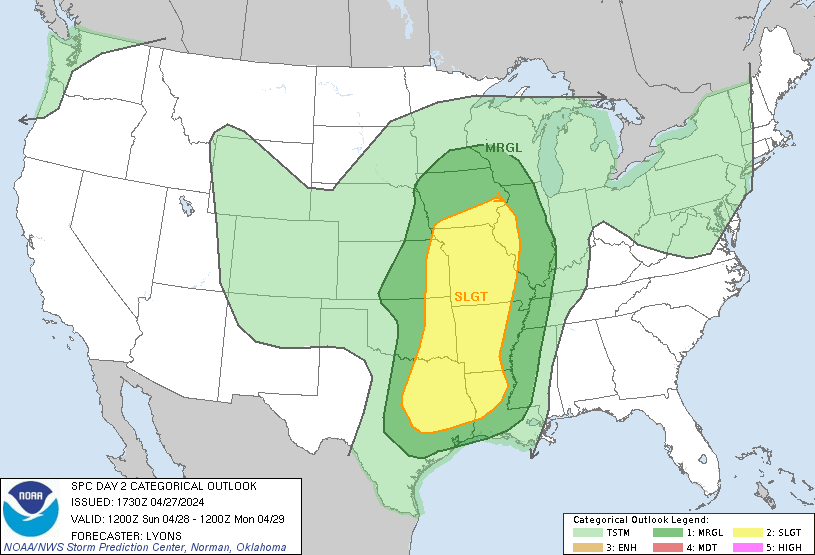

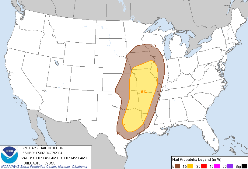

Tomorrow will feature some risk for organized severe thunderstorms again, for the Mid-South, Midwest, and even parts of the Eastern Plains again. This looks to be more of a damaging thunderstorm wind/large hail threat, more of a routine severe weather threat than the higher-end threats they've dealt with yesterday and today. But a few isolated tornadoes are still possible across that broad swath of land outlined in these SPC outlooks as well.

Then the threat for any severe thunderstorms becomes marginal/isolated on Monday, but does include Southern Mississippi.
But overall the only time period we might have to keep an eye on this time for the Southeast is Friday and Saturday of this coming week. So we'll look at the forecast day by day and see how that looks for the counties of North Alabama into Southern Middle Tennessee.


First off, tomorrow looks like another great day, mostly sunny skies, High of about 80 or so, Low tonight near 60. And we'll have a southerly breeze again, but it may be winds up to more like 10-15 miles per hour instead of the 20 mph or greater gusts we saw today.


On Monday, that high pressure ridge eases up and moves to the East enough to allow that front to creep in here just a little bit. This is when Southern MS may have a risk for isolated severe thunderstorms. Here in North Alabama up into Southern Tennessee, only expecting some general rain and thunderstorms. And during the day, even that will be isolated, about a 20% chance (or 1-in-5) of any one spot getting wet. High should be 80 or so again, Low near 60. And we will have that southerly breeze again.

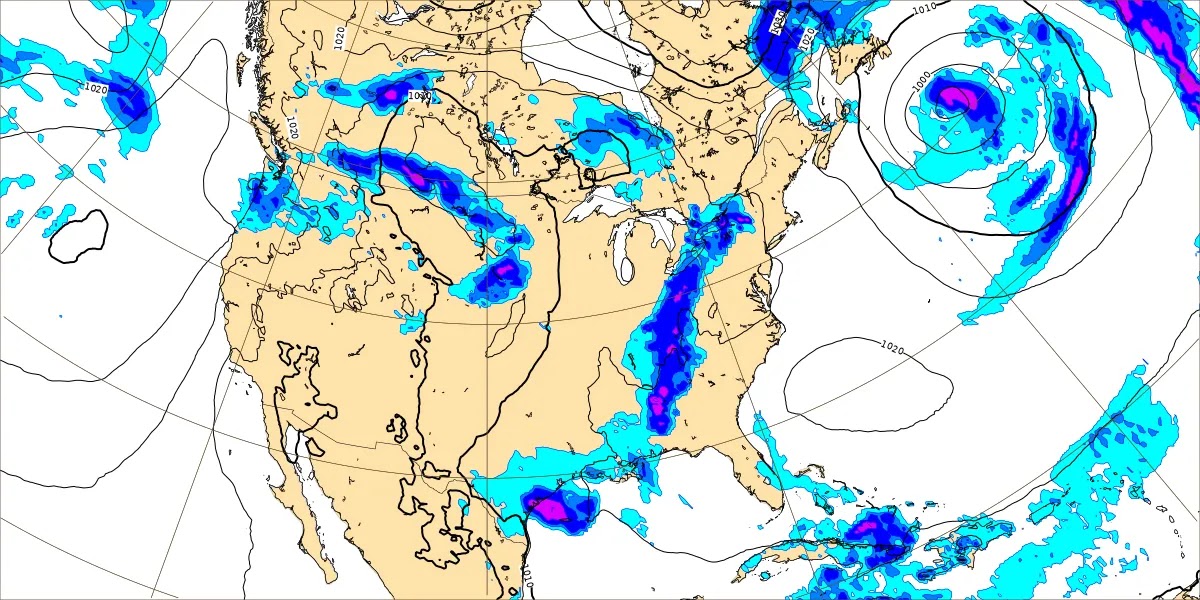
Even looking at an intermediate time, 1 AM Tuesday morning via the GFS, it doesn't make the overnight rainfall look all that widespread or heavy.

The NAM is a little more aggressive with the overnight rainfall potential. And you do have to give it some respect at this time range.


The GFS has us dry by Tuesday, and the NAM look was similar.
The ECMWF wants to drag that front through here more slowly. In this case I think it has this wrong. The first time a meteorology professor talked to me about the European model, he said he didn't know much about it, but that it was "sick." It often is, but the American model got an upgrade within the past few years. And I've seen several times it outperformed the European. Also have to take into account what the various models were showing on previous days. Can't really isolate one or two runs of the models and just assume that is the correct solution because it is more recent.
Considering everything, going to cap off rain chances at 20% again for Tuesday. Now overnight, Monday night into early Tuesday morning, the chance of rain or a thunderstorm is more like 40-50%. The higher chances in Northwest Alabama and adjacent parts of Tennessee. My forecasts are centered on Cullman here, but I sort of scan around for everybody else in North AL/S. Mid. TN too and try to mention things. The High here should be about 80, Low about 60 again.


On Wednesday the situation is flip-flopped somewhat, the GFS here wanted to keep isolated rain as a possibility, and if you glance at the European, it has us totally dry. Will defer to the American model again given the overall pattern (unsettled, more like Summer than Spring . . . but we will be into the month of May by then, this is May 1st). Looks like a High in the lower to mid-80's, more sun than clouds overall even if we do get isolated rain, the Low dropping a degree or two into the upper 50's.
It doesn't look like that front coming in Monday is going to survive down here too well against the high pressure ridge that has been in place a long time.


On Thursday again expecting a High in the mid-80's and Low near 60. The GFS still shows a minimal chance of rain, mainly for Southern Tennessee instead of Alabama counties, but I guess I'll include a 20% chance of rain even this far out. The ECMWF still keeps us dry (like for Wednesday), but I don't think it is picking up on this unsettled summerlike pattern nearly as well as the American model this time.


Another cold front will take aim at our region by Friday. It doesn't really look like a strong storm setup synoptically, but Highs are expected to still be in the lower 80's and Lows in the lower 60's. And it is early May. So it's good to always keep an eye on these things, even in case one or two thunderstorms try to get out of hand and reach severe limits. But the low pressure system looks like it will stay way up in the Great Lakes region.


The combination of unstable air and wind shear looks meager Friday morning, if you can believe the GFS at this time range for mesoscale parameters. But this would fit with the synoptic setup of the Low being displaced so far to our North even though the trough axis does have a negative tilt. This shows moderately unstable air but very little wind shear to work with. And any threat for organized severe thunderstorms would probably fall apart around here. We could see some isolated stronger storms with this setup, especially considering the time of year.
So it's worth keeping an eye on if you want to play it safe. But it does not look particularly threatening.
The High should be 80 or so, Low of 60 or so. (The temperature just isn't very exciting in this forecast, reminds me of summer but ten degrees cooler.) And for now, will keep rain chance down at 30-40%.


On Saturday we get into more of the usual model madness with the GFS eager to rush this front (which looks weak in our region at least) through the area.

While the European model has a slower timing of it on Saturday.
At this point, only going to include a 40% rain chance for Saturday and expect a High of 80 or so, Low of 60 or so.
Trying a 10-day-outlook here would be pointless. Because we have to default to probabilities for Days 6-7 just because the timing of the second front is unclear. Anything beyond that would basically just be a guess. As much fun as it can be to try to expand the time period we can forecast for, lots of times I think our energy would be better spent as meteorologists (or in my case, a meteorology student whose current status of education is firmly in the self-taught zone, but did take some college at one point, when I was able to) in trying to get it right, what we can already do. Being able to forecast a week in advance is great in itself. It's probably better to just work on getting that more accurate, and communicate to the general public when we have uncertainties, especially in the extended 4-7 days outlook, in a way that makes sense. That's why I use PoPs for Days 4-7 but tend to minimize them for the first three days of a forecast. We need to figure out ways to show the difference in what we have high confidence in and where we have to express it in probabilities, without always writing the general public a thesis. So I'm working on it on this blog, trying out different things and seeing what works and doesn't.
Sometimes the communication issue brings up some funny stuff. I realized the other day that when trying to do bilingual forecasting, it really might not make sense to Hispanic readers to say "May the Fourth be with you", which is a common joke in the English language, at least among Star Wars fans. But we have to think about these things. And when I hear the "go back where you came from" mentality, I wonder how many of those guys would keep that attitude if they saw it applied to somebody like Sofia Vergara. All joking aside, the circumstances under which she emigrated to our country were definitely unpleasant. She had a really good reason, and it wasn't just wanting to be a model or actress.

Rainfall amounts for the next week will average about one inch.


No comments:
Post a Comment