

FORECAST:
Friday (High 81, Low 59): Partly to mostly sunny. Warm and breezy.
Saturday (High 82, Low 61): Mostly sunny. Warm and breezy.
Sunday (High 84, Low 62): Mostly sunny. Warm.
EXTENDED OUTLOOK:
Monday (High 83, Low 62): Partly cloudy with a 20% chance of showers/thunderstorms.
Tuesday (High 80, Low 63): Partly to mostly cloudy with a 30% chance of showers/thunderstorms.
Wednesday (High 81, Low 62): Partly cloudy with a 20% chance of showers/thunderstorms.
Thursday (High 82, Low 61): Partly cloudy with a 20% chance of showers/thunderstorms.
READING TEA LEAVES:
Friday May 3 (High 83, Low 61): Partly to mostly sunny with a 20% chance of showers/thunderstorms.
Saturday May 4 (High 85, Low 59): Mostly sunny - and May the Fourth be with you.
Sunday May 5 (High 86, Low 58): Mostly sunny.
PRONÓSTICO:
Viernes (Máxima 81, Mínima 59): Parcialmente a mayormente soleado. Cálido y ventoso.
Sábado (Máxima 82, Mínima 61): Mayormente soleado. Cálido y ventoso.
Domingo (Máxima 84, Mínima 62): Mayormente soleado. Cálido.
PERSPECTIVA EXTENDIDA:
Lunes (Máxima 83, Mínima 62): Parcialmente nublado con un 20 % de probabilidad de lluvias/tormentas eléctricas.
Martes (Máxima 80, Mínima 63): Parcialmente a mayormente nublado con un 30% de probabilidad de lluvias/tormentas eléctricas.
Miércoles (Máxima 81, Mínima 62): Parcialmente nublado con un 20 % de probabilidad de lluvias/tormentas eléctricas.
Jueves (Máxima 82, Mínima 61): Parcialmente nublado con un 20 % de probabilidad de lluvias/tormentas eléctricas.
LEYENDO LAS HOJAS DE TÉ:
Viernes 3 de Mayo (Máxima 83, Mínima 61): Parcialmente a mayormente soleado con un 20% de probabilidad de lluvias/tormentas eléctricas.
Sábado 4 de Mayo (Máxima 85, Mínima 59): Mayormente soleado.
Cinco de Mayo (Máxima 86, Mínima 58): Mayormente soleado.
NOTES:
This Sunday will mark the anniversary of the notorious April 27, 2011 tornado outbreak. Tornado events of such unusual severity seem to only happen about once every 30-50 years. We had a similar one in 1974, and some events that are not as well-documented, but appear similar, in 1932 and 1884.
It is interesting that we had a preview event on April 15, 2011, which was still one of the more widespread tornado outbreaks we'd seen in a while. Likewise, the 1974 event was preceded by an April Fools Day Outbreak, which was no joke for the people affected.
Brian Peters said in the early 2000's that it wasn't a matter of if a similar outbreak (to 1974) would happen, only a matter of when. And he was afraid the death toll would be even higher, because there were more people living in these towns, and people did not pay as much attention to preparing for severe weather. He got it right. Whenever we have another outbreak like that, I am pessimistic as to the outcome being any better than it was in 2011. I guess I will just try to do my part if I'm still around by then.
I remember the night of April 26 that year, I sent special messages to basically everyone I knew, saying that even if they weren't reading my weather posts online, this was as bad a tornado setup as I'd ever seen in my life. I kept comparing it to other events like the April 8, 1998 one that produced an F-5 or the Veterans Day Outbreak in 2002 or the more recent Super Tuesday Outbreak in 2008, and thought it was going to be at least that bad. I did say to one person, wouldn't it be something if it was even worse than that, like 1974? But I was mostly joking. I was just nonplussed at what a dangerous setup it looked like. I didn't quite know what to make of it. And I was one of those people who thought we'd probably get a morning round of severe weather that would stabilize the atmosphere so that it wouldn't get quite as bad as it was looking. And let me tell you, that day was a nightmare. Because we did get a squall line in the morning, one of the worst I've ever seen, produced a lot of tornado damage and wind damage, knocked a lot of people's power out. And then the atmosphere recovered very quickly for the afternoon to be "a living hell", as Shea Fox from Rocket 95.1 FM so bluntly and eloquently put it on the air a day or two later. And some people forget, North Alabama actually had a midday round. I actually saw the tornado that moved between Decatur and Huntsville during that time period but had a crappy old cell phone that wasn't good at taking pictures. I watched it with a bunch of janitors, who all ran to the basement before I did. After a while the funnel just got too close, even though it was still behind some trees. I don't deny there was some thrill in the mix, but thinking back to that day still gives me a feeling of "ugh", like there is a part of me that does not even like to remember it. On some documentary later that year, I saw that it was a day that even sobered Reed Timmer up, like instead of whooping and hollering that he'd managed to get "inside the tornado" or whatever, he was humbled by seeing the way those tornadoes devastated people's lives. That was the same year as the Joplin, Missouri tornado. And it was just rough stuff. That event looked ominous even about a week in advance, the April 27 one. But we'd had so many events that looked scary and then busted. I remember feeling skeptical and then having to admit, "But this one still looks pretty bad." And with each day as the event got closer, it looked worse. When I saw the first tornado that hit downtown Cullman, I knew it was as bad as it had looked. That one ended up being rated F-4. And by the time the other supercell that produced an F-5 tornado (turned out to be the rating, E/F-5) was moving through Harvest, I honestly wondered if I was living through something like 1974. And the next day, on my solar/windup radio, I heard Chris Darden from the National Weather Service (he had taken over the Huntsville office after Mike Coyne got promoted to the Southern Region headquarters, and after his great work that day, they kept him . . . now Mr. Darden is head of the Birmingham office) say, "This is taboo to say as a meteorologist, but the only event I can think of that would compare to this one would be the outbreak of April 3, 1974."
I've spent a lot of words on it, but bottom line, if you ever live through a tornado outbreak like that, you won't forget it. I am still nonplussed that nobody I knew directly was killed in it or even badly injured. My brother knew someone from the Hallmark family that were "blown up", as he impulsively put it, in Arab. I told him we'd gotten so lucky, and he said, "Actually I know of a family from work that were . . . blown up . . . in their house." And we had a hard time talking for long since the power was still out and cell service was spotty. People may not remember the big scare about the Mayan calendar and 2012, but there were people joking that the Mayans were right and that they'd guessed the apocalypse was coming too late. Like that tornado outbreak had to be the end of the world as we knew it. Even though December 2012 was supposed to be the apocalypse. Of course, that doomsday forecast did not verify any more than any of the others over the years (many many years). But that's how overwhelming that tornado outbreak felt.
I also knew a couple of brothers who went sightseeing the damage from the F-3 that hit Cordova in the morning, only to find themselves running from the F-4 that hit Cordova in the afternoon. They had a close call, even if it was their own fault. I remember a video of a couple of idiots who nearly got rolled by the F-4 (which I always thought should have been rated an F-5 . . . Greg Forbes said in a lecture I saw that Ted Fujita would have come out of his grave to rate that one a 5) that hit Tuscaloosa that same afternoon. Basically all they could do was drive recklessly and spew more profanity than a juicy George Carlin routine. I also remember a responsible chaser named Mike Wilhelm, though I forget his chase partner's name now, who got good video of the Tuscaloosa tornado from a safe enough vantage point, and asked that his video not be broadcast outside of YouTube, because he was praying for the people in the path. And he considered that too personal to be on a broadcast. Mike died a few years ago, seemed to come out of nowhere. But I was always glad he was there to balance out the people who looked at the event in an exploitative way.
After such tangents, probably nobody will read my other notes, but I'll include them anyway.
Well really the only other thing I was going to mention was to remind people of the Weather 101 classes still being offered by the National Weather Service in Nashville. That is a great effort they make. I don't think they are doing any more classes on severe weather this Spring, but I did see they are covering rip currents, tsunamis, and hurricanes. Sometimes they do another round of classes at one point in the Summer or Fall season. They do a really good job with these, and they are suitable for all ages. They make it easy to understand, whether you're someone like me who dropped out of school but never lost the meteorology interest, or whether you've got a kid in your family who finds it interesting. It is easy to understand.
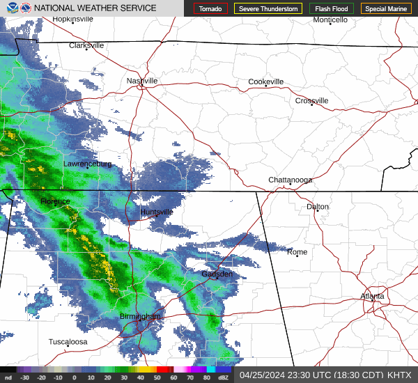


Overall it was a mostly sunny day in the Tennessee Valley with light Northerly winds. We have some rain moving in along a warm front this evening. The High in Cullman was 75, after a morning Low of 45. Jasper saw a High of 79 and Low of 46. Haleyville saw a High of 73 and Low of 48. Fort Payne had a High of 75 and Low of 42. Gadsden had a High of 77 and Low of 45. Decatur had a High of 75 and a Low of 49. Huntsville had more cloud cover today but saw a High of 76 and Low of 52. Muscle Shoals saw a High of 73 and Low of 52. Tupelo saw a High of 73 and Low of 51. Memphis had a High of 66 and Low of 57 today. And Nashville had a High of 74, Low of 47.


After these off-and-on showers tonight, looks dry tomorrow, skies becoming mostly sunny. The High should be about 80 or so, the Low in the upper 50's. It will be a breezy day as we've just had a front move through.


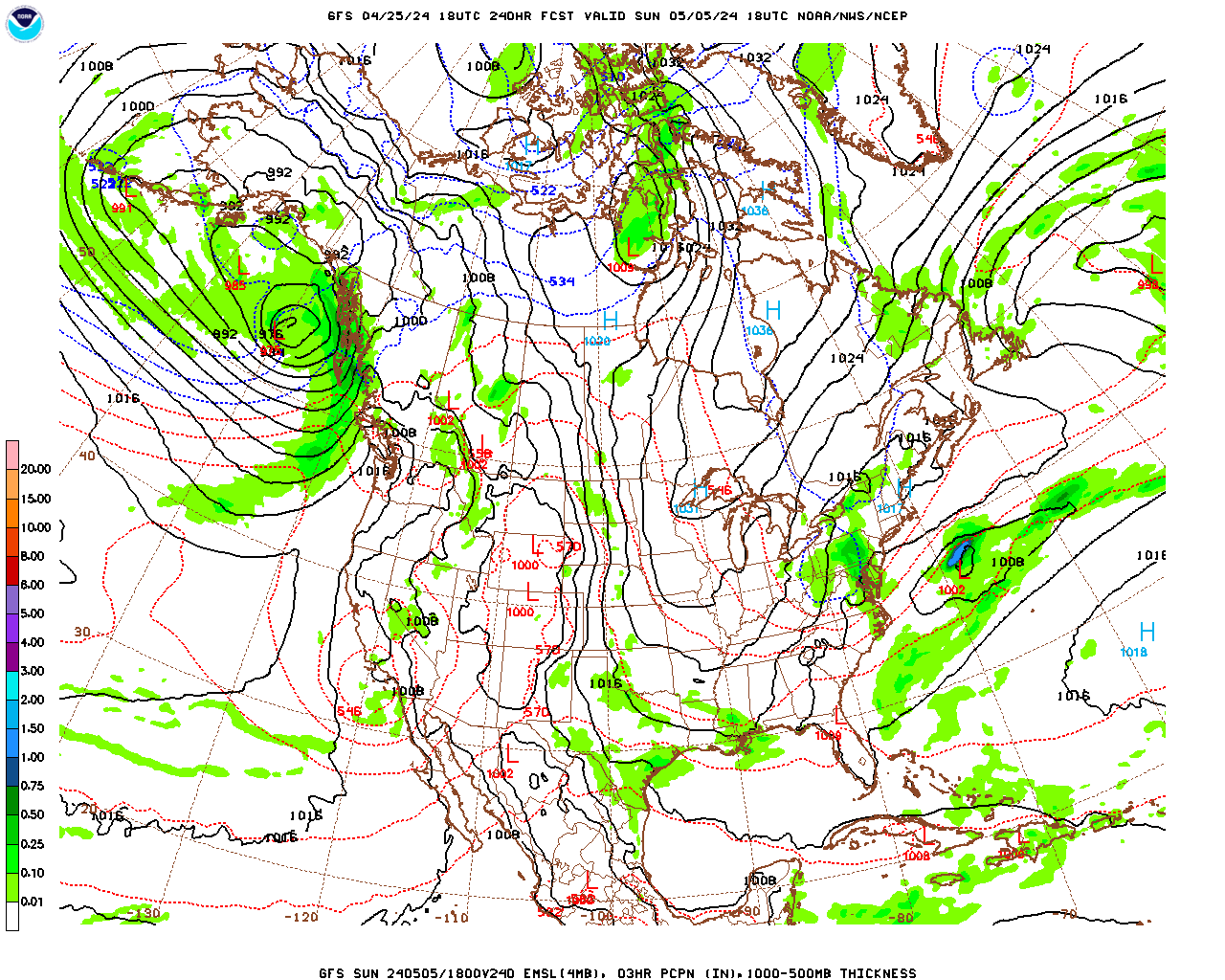
Basically we have an upper-level ridge of high pressure that is keeping all the "interesting" weather out West, or sometimes deflected to our North in the Ohio Valley or Midwest. But mainly it is staying out in the Plains, the focus for severe thunderstorms.
Saturday again looks like partly to mostly sunny skies, High of 80 or so, Low around 60 or so. And we will continue to have a little bit of a Southerly breeze.


And again on Sunday, mostly sunny skies, High in the lower 80's, Low in the lower 60's.


It isn't until Monday that the ridge starts to give way enough to let the front approach our region.
And even here, only see enough evidence to bring back a minimal 20% chance of rain. The High should again be in the lower 80's, Low in the lower 60's. This feels like a Summer pattern but with milder temperatures.


It sure looks like that front will weaken drastically on Tuesday as it comes into the Southeast region.

Although the ECMWF doesn't show that quite as much as the GFS.
Will stick with a 30% chance of rain here, so about a 1-in-3 shot at any one spot getting a shower or thunderstorm.
Once again we should have a High of about 80, Low of 60 or so.


Then the GFS has shifted to having us some moisture available even into Wednesday. Not sure if I buy this, but will consider it for the extended forecast. The ECMWF shows much more meager moisture.
So if we have to put in rain chances for Wednesday, let's cap them off at 20%.
Once again a High near 80 or so, Low near 60.


And that unsettled pattern appears to continue into Thursday, so only a 20% chance of rain if that, and a High in lower 80's, Low of 60 or so.

Looks like we may get a frontal passage between Friday and Sunday, so can remove rain chances by Sunday probably. But really a 10-Day-Outlook here is going to be an educated guess at best. High temperatures should climb more into the mid-80's instead of lower 80's. And with the air drying out, Lows could dip back below 60 in the 8-10 day period. Should keep rain chances in at least for Friday.
But really even in days 4-7, I think the best policy is to blanket the whole period with a 20% rain chance. I'm not convinced that Tuesday merits a bump up to a 30% chance after all. The overall pattern looks unsettled like in the summer months.


They do have a risk for organized severe weather in the Plains tonight. And already today, mainly in Kansas, they've had several reports of hail. But you can also see scattered reports of wind damage in that region and a couple of tornado reports.


Tomorrow and Saturday, that risk will extend into parts of the Midwest and Mid-South. And it could be a fairly significant event for some folks. Then the Midwest/Mid-South has another chance for organized severe weather on Sunday.
No severe weather is expected down this way any time soon. Although we always have to watch the month of May, usually early May, about the first week or two, but occasionally we'll still get a powerful storm system more toward the end of May. By June we can pretty much declare it summertime and hand the severe weather off to our neighbors in the Plains. At the moment, I'm wondering if we are doing that a little early this year. But the climate is variable. Every year is going to be a little different with how weather patterns behave.

Average rainfall totals around here should stay at a quarter-inch or lower for this forecast period.
I went ahead with the slightly higher rain chance for Tuesday after all. But please understand that this is a lot like in the Summer, where it's not going to rain for everyone every day. Overall this is a dry forecast, with most days, the chance of getting a shower or thunderstorm only about 1-in-5.


No comments:
Post a Comment