

FORECAST:
Sunday (High 80, Low 51): Mostly sunny. Cool in the morning, warm in the afternoon.
Monday (High 74, Low 57): Mostly cloudy with scattered showers and thunderstorms possible during the day. Rain is likely at night.
Tuesday (High 76, Low 61): Mostly cloudy. Numerous rounds of showers and thunderstorms are possible.
EXTENDED OUTLOOK:
Wednesday (High 79, Low 59): Mostly sunny.
Thursday (High 82, Low 58): Partly cloudy.
Friday (High 78, Low 63): Thunderstorms likely - some may become severe.
Saturday (High 83, Low 62): Sunny.
PRONÓSTICO:
Domingo (Máxima 80, Mínima 51): Mayormente soleado. Fresco por la mañana, cálido por la tarde.
Lunes (Máxima 74, Mínima 57): Mayormente nublado con posibles lluvias y tormentas eléctricas dispersas durante el día. Es probable que llueva por la noche.
Martes (Máxima 76, Mínima 61): Mayormente nublado. Es posible que se produzcan numerosos chubascos y tormentas.
PERSPECTIVA EXTENDIDA:
Miércoles (Máxima 79, Mínima 59): Mayormente soleado.
Jueves (Máxima 82, Mínima 58): Parcialmente nublado.
Viernes (Máxima 78, Mínima 63): Es probable que haya tormentas eléctricas; algunas pueden volverse severas.
Sábado (Máxima 83, Mínima 62): Soleado.
NOTES:
Here are the latest tornado surveys as of last night. They still have some work to do in finalizing all their findings.
This has been Hurricane Awareness Week, and this season is expected to be unusually active, so might be worth reading back over some of that stuff.
On the better side of summer coming up, a lot of people will be going to the beach, and here is some advice on how to get through a rip current if you ever find yourself caught in one.
DISCUSSION:


It is mostly sunny in Jasper and 73 degrees. The dewpoint is 54, making the relative humidity 50%. Wind is from the East at 5 mph. The pressure is 30 inches and steady.
And it is mostly sunny in Haleyville with a temperature of 69 degrees. The dewpoint is 50, making the relative humidity 51%. Winds are from the West at 6 mph. The pressure is 30.04 inches/1016.1 millibars and steady.
We have a cooler, dry airmass this weekend, at least as cool as it gets here in May. High pressure is moving into the region from out in the Plains.


We'll have high pressure in place again tomorrow, mostly sunny skies, a High near 80 and Low near 50 or so.


On Monday we'll have a front ahead of a low pressure system over the Plains/Midwest.

The NAM and GFS are in good agreement now showing slightly higher rain chances than before during the day Monday. So bumping the rain chance up to 40-50% seems reasonable. Going to adjust the High temperature down to about 73-74, the overnight Low should be in the upper 50's, about 57-59 range.
Showers will probably be scattered during the day Monday and then become likely overnight, could see isolated thunderstorms in the mix.

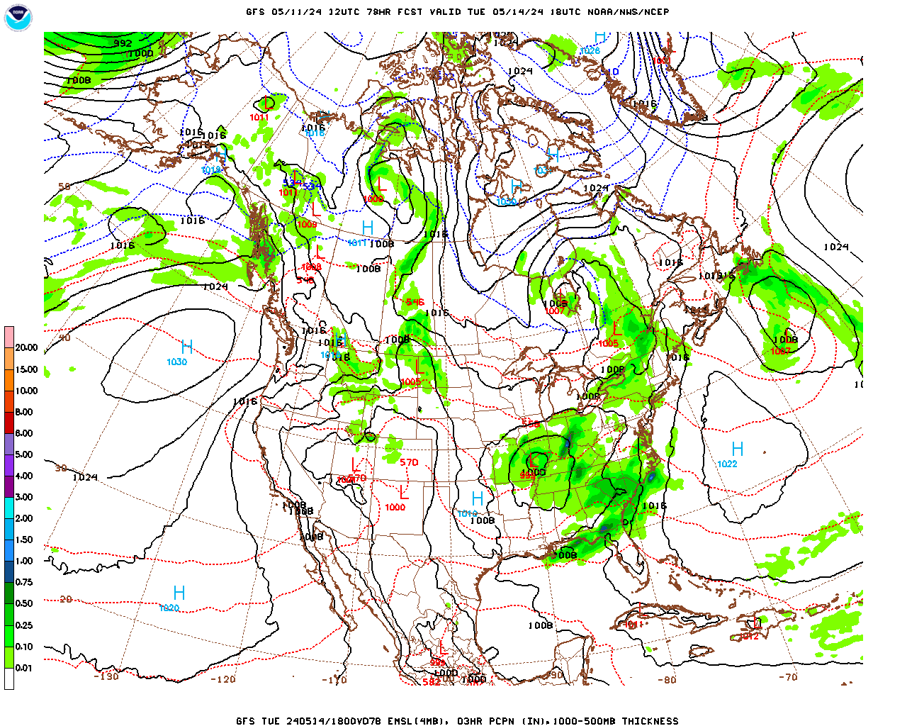
Tuesday a 50% chance of rain looks like the best estimate. I'm really not liking the model estimates for temperatures, wanting to push us into upper 70's again, think mid-70's are more realistic here, about 74-77 range, and then the morning Low about 60 or so. We could see isolated thunderstorms, but a lot of it may just be rain. Most of the rain looks to come overnight between Monday and Tuesday, but it looks scattered during the day Monday, more numerous across the local map on Tuesday.


Wednesday continues to look like a break in the rain, more sunshine than clouds overall. The High should get back into the upper 70's, and the Low should still be near 60, might dip into upper 50's for some of us around here.


And it actually looks the same for Thursday. Might see a few more clouds. High near 80 or so, Low down in the upper 50's with a brief break of drier air overnight.


We might see some rain overnight, but it looks like it'll mainly come in during the day Friday, maybe starting early Friday morning. As we're getting this far into the extended period, the exact timing is a little more dicey. Looks like a High near 80, but with the rain probably more upper 70's, the Low about 60 or so.
As far as severe thunderstorms, we'll have to keep an eye on it.


It's tough to rely on guidance for parameters this far out, where this is six days away, but from the clues we do have with the GFS here, it does show a fair amount of unstable air and wind shear getting together over mainly Central and South Alabama but also working into North Alabama between about 4 and 7 PM.

And again, don't take this to the bank, it's six days out, but the GFS if you take a forecast sounding down around Smith Lake, is showing at 7 PM we've got strong instability and ample wind shear, including enough helicity to support a tornado threat. The supercell composite gets up to about an 8, and the significant tornado parameter up to a value of 2. And usually the GFS doesn't look this concerning six days in advance. So it's something to watch, since it looks more favorable for severe thunderstorms than it did yesterday.
I can think of all kinds of things that could bust the severe weather threat though. It's almost useless to speculate at this time range except just looking at the overall trends to see how closely you're going to need to watch it. But it is the weather geek and latent storm chaser coming out in me I guess. It's even more of a question if the unstable air can make it very far into Tennessee, or even extreme North Alabama, if you do believe this guidance.

Decided to look at the European model, and it's got our dewpoints way up in the 60's Friday evening. So that points to unstable air too. So I think we probably will have some issues with severe weather potential with this system on Friday. It's more a matter of where that tries to set up. It might be more in Central or South Alabama. You could see the trend of the warm unstable air moving Northward looking at the GFS guidance for the energy-helicity-index.
It's really too soon to call, but based on what we can see right now, the next time I'd watch for organized severe thunderstorm potential is Friday into Friday night. May even mention that in the official forecast, after the way this last event overperformed. Like Dan Satterfield mentioned the other day, I think during the event, the record-high ocean temperatures are not just going to bring us an active hurricane season, but the water vapor is fueling a lot of these severe weather events we've had in different parts of the country lately. Too soon to know if everything will come together just right for another organized threat, but I am already slightly concerned. Like we do need to watch this one.


The two global models are in good agreement that we will be clear again for Saturday. Not much temperature change, High in lower 80's, Low in lower 60's.

Rainfall totals for the next week will probably be about 2-3 inches on average. Areas that had flooding issues from this last system obviously will want to monitor things, but for now, the outlooks for excessive rainfall are not showing anything alarming, only low-end chances of excessive rainfall. I'd still watch Friday in case we do get heavier storms, since they can dump a lot of rain in a hurry, like we had with the last event. Not sure whether Friday will be an event at all, but think I will err on the side of caution here and make mention of it up top in the official forecast, since this is the one starting at the beginning of the week and going all the way to next Saturday. More of a chance people will read it and pay attention.
Started to have some fun and try to look at days 8-10, but the spread between the GFS and ECMWF is so much that it just isn't worth it. Go read the Farmer's Almanac or shake up a Magic 8 Ball or something, probably be about as accurate. I might lean a little more toward the European solution of keeping us dry, but it's too hard to know this time of year, when until we get to June, the weather pattern can still be pretty dynamic, if not as active as March and April.
The only reason I even looked is that I was surprised at how well the global models agreed on days 6-7.
On a personal note, this last severe weather event really took it out of me. Whenever Father's Day rolls around, you'll see James Spann post about how it's not a happy day for him, the way it is for a lot of people. It certainly is not for me either. Neither is Mother's Day. Yet my mother was near the path of one of the tornadoes that ended up being rated F-3 the other evening. About the time I verified that she was all right, some family members I'm (usually) on much better terms with found themselves in the path of another supercell with a confirmed tornado, that looked like it might hit them directly. It didn't, and it was in a weakening phase when it came so close anyway. But I haven't heard from them at all since that night. They generally get annoyed at my weather reports anyway. This time, it all hit me in the worst possible way. I have been in a state of brutal depression since the other night and having a lot of flashbacks to 2011, that outbreak that was so much worse, and the summer that followed. I have that same sense of despondency about ever improving relations in what is left of my family. And there wasn't a whole lot left of it even in 2011. I wish I had given up a long time ago. Some fools never learn.
Generally not a fan of the oversharing era, but things are almost unbearable right now. And like I say, I couldn't get hold of my loved ones to let them know how glad I was that they were okay. So I throw some of my thoughts out randomly on the interwebs like any other fool would.
[9:57 PM]: Beautiful shot of the #Auroraborealis in Cullman, AL! Hurry outside and try to get a glimpse of them. They should be visible across much of the Tennessee Valley #HUNwx https://t.co/YhQdtaE4a8
— NWS Huntsville (@NWSHuntsville) May 11, 2024
On a lighter note, and I do mean lighter, the Northern lights were visible down this way last night, thanks to an unusual solar storm. I think I was about an hour too late venturing outside. All that happened was that my crazy little cat, Salem, made an escape and ran around a while before I was able to get him back inside. And a neighbor let me know some more depressing news that is better not passed along, since it is someone else's business. By the time that conversation was over, my psychotic little feline buddy actually came running back to me, not feeling like such a wild man after all. So I was glad to bring him back in. It sure was a nice, cool night.
Curry, AL @spann pic.twitter.com/hhc9kj0XmP
— Lori Gibson (@Gib216) May 11, 2024
This view from Curry down in Walker County was absolutely stunning. Looks like a work of art, some great painting or something, but right there in the sky.
Look North tonight- good chance to see the Northern Lights again! @NC5 pic.twitter.com/4eqAF77NxK
— Bree Sunshine Smith ☀️ (@NC5_BreeSmith) May 11, 2024
And we may have another chance tonight after sunset. So maybe I'll catch them after all. Certainly encourage any readers to do the same.
There's an old country song that talks about the Northern lights and the outdoors at night, so I guess I'll leave everybody with a link to that. It's a depressing weekend for me, but there are ways to enjoy depression, and country music is one of the best.


No comments:
Post a Comment