

FORECAST:
Sunday (High 83, Low 61): Mostly sunny. Warm.
Monday (High 85, Low 60): Sunny. Warm with low humidity.
Tuesday (High 87, Low 62): Sunny. Very warm with low humidity.
EXTENDED OUTLOOK:
Wednesday (High 89, Low 65): Mostly sunny.
Thursday (High 88, Low 67): Partly cloudy with a 20% chance of showers/thunderstorms.
Friday (High 86, Low 70): Partly cloudy with a 30% chance of showers/thunderstorms.
PRONÓSTICO:
Domingo (Máxima 83, Mínima 61): Mayormente soleado. Cálido.
Lunes (Máxima 85, Mínima 60): Soleado. Cálido con poca humedad.
Martes (Máxima 87, Mínima 62): Soleado. Muy cálido con poca humedad.
PERSPECTIVA EXTENDIDA:
Miércoles (Máxima 89, Mínima 65): Mayormente soleado.
Jueves (Máxima 88, Mínima 67): Parcialmente nublado con un 20 % de probabilidad de lluvias/tormentas eléctricas.
Viernes (Máxima 86, Mínima 70): Parcialmente nublado con un 30% de probabilidad de lluvias/tormentas eléctricas.
Sábado (Máxima 88, Mínima 69): Mayormente soleado.
NOTES:
The National Weather Service offices in Huntsville and Nashville have both put together pages on the May 8-9 severe weather event.
The weather radio transmitter in Lawrenceburg, TN is offline at the moment.

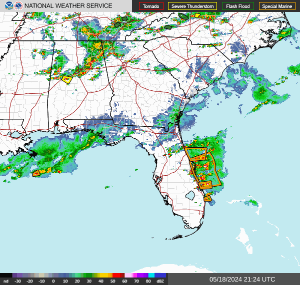


It has been variably cloudy and breezy at times in the Tennessee Valley today, with a fair number of showers and thunderstorms. A few storms have been strong, and one near Village Springs, Highway 75, the Blount/Jefferson County line broke some power poles from straight-line winds, so that counts as a severe thunderstorm. I believe there was a severe thunderstorm warning earlier for Morgan and Madison Counties, so we'll see if any minor damage reports come in from there. Most of the severe thunderstorms, whether producing damaging winds or large hail, have stayed down close to the Gulf Coast today, also yesterday. We mostly have had general thunderstorms up here, and a lot of places even had rain without thunder. The High was 79 in Cullman, and the Low was 68. In Huntsville the High was 77 and the Low was 68. And in Nashville, the evening is not over, but it looks like 79 will be the High, and the Low was 67 this morning.
We'll still see widely scattered rain and some thunder this evening and tonight before this front finishes clearing the region.


Tomorrow high pressure moves back into the region, and even the chance of any isolated rain lingering in the morning looks low.

I think we'll be mostly sunny tomorrow, probably no lingering rain tomorrow in the morning, just a few clouds. I think the NAM has a better handle on it than the GFS, it's really good at this time range. High should be about 83, Low tonight about 61.


The ridge looks strong over the region on Monday, sunny skies, High near 85, Low near 60.


Even though the center of high pressure is well to our Northeast off the Atlantic coast on Tuesday, this pattern will keep us sunny with low humidity levels but much warmer temperatures than we've had in a while. The High should be in the upper 80's, the Low in the lower 60's.


And it looks like the ridge holds on Wednesday even as a front brings rain and storms back to the Ohio River Valley. Should be mostly sunny here with a High in the mid-to-upper-80's, Low in the mid-60's.


Then on Thursday, that front looks like it will weaken a lot as it moves into the Southeast/Tennessee Valley, if not "wash out". Peeked at the European just to compare, and it shows the front stalling out to our North instead. Either way, our rain chances look pretty low. A 20% chance of rain looks like it should cover this. The coverage of rain probably won't be any more than on a typical summer day. Should see a High in the mid-to-upper-80's again, Low in the mid-to-upper-60's.


The GFS shows more moisture here on Friday with the remnants of the front.

The ECMWF keeps most of the rain to our North. Might increase rain chances to 30% here, definitely keeping at least a 20% chance in for Friday. The High should be in the lower-to-mid-80's, and the Low should be in the upper 60's.

Then Saturday I think we're mostly sunny again with rain chances so minimal that it's not worth putting them into the forecast, like 10% or less. High should be more toward the mid-80's and the Low more toward the mid-60's.
We're just about into summer now, and this next week is probably a good indicator of what our pattern will be for the next few weeks until we get into the heat of the season.


The chance of any storms becoming severe around here the rest of tonight looks very low.
Tomorrow they have a threat for organized severe weather in the Plains.
Then Monday the threat is more in parts of Kansas and Nebraska, up to Southwest Iowa and clipping places like Kansas City in Missouri.
Then on Tuesday, an even more organized and perhaps more significant threat for severe weather is focused on the Midwest, though some risk extends from the Great Lakes back down to Oklahoma.
And then on Thursday, looks like the focus for organized severe thunderstorms will be in the Ark-LA-Tex region.
Meanwhile we are mainly just going to be getting our first taste of summer heat around here. At least we've got time to get used to it gradually. This summer may be interesting, at least in the tropics, with record-warm ocean temperatures. The hurricane season of 2020 was the most active on record, and this one might give it some competition. They have two sets of names ready just in case it does get that active.

Rainfall totals will average about a half-inch to one inch for this forecast period. The rain will be random a lot like if it was already summer. We probably won't see any more after tonight until Thursday.
As I'm writing the forecast now (will be up top), I remember how my grandpa used to give me a bowl of hot soup or cup of something and say, "It's warm, now." And then laugh if I didn't pay attention and sort of scalded my tongue. I miss those understatements of his and that wonderful belly laugh. But my rule of thumb is that I'm usually not going to say it's "hot" until we break 90 degrees. And then in the middle of summer, probably won't mention it's unusually hot unless we get to about 95 or so. Or if the humidity makes it feel awful, more than usual.
Yet I also feel in the final analysis, I'm forecasting things a little warmer than most the other forecasts I've read. More like what the models were showing days ago than what they are showing now for specific temperatures each day. So if you care enough to read this far . . . assume it'll be hot some of these days if you wish.
Some girls in my family tree are going to a concert tonight, and I knew they like Billie Eilish, so asked if that was the concert, and no, it was actually the Steve Miller band. I told their dad that Billie was hot, kind of like our weather next week, and he said, "So I've been told."
But never fear, next week's weather is not looking as hot as your favorite singer, like Sara Evans would be another example, not gonna' be as hot as she is, but still, it might remind you of that Alan Jackson song about the Chattahoochee at times. Some of my readers might think he is hot, but I can't see it myself. Call me cisgendered or whatever epithet, but I say, thank the Lord most women don't have mustaches, even though a lot of them look good with long hair and cowboy hats.
And if I keep talkin', we all know it only gets worse, so I'm signing off and wishing you a nice toasty week ahead, where if you're in good shape, you might only find it pleasantly warm . . . who am I to judge . . .


No comments:
Post a Comment