11:34 - They've gone ahead and extended the warning into Georgia as a Particularly Dangerous Situation. So people need to take cover from this well ahead of time.
And let's not forget that other storm behind it that may also be producing a tornado. Any tornado is dangerous, it doesn't take an extra-bad one like we have here in Dekalb County.
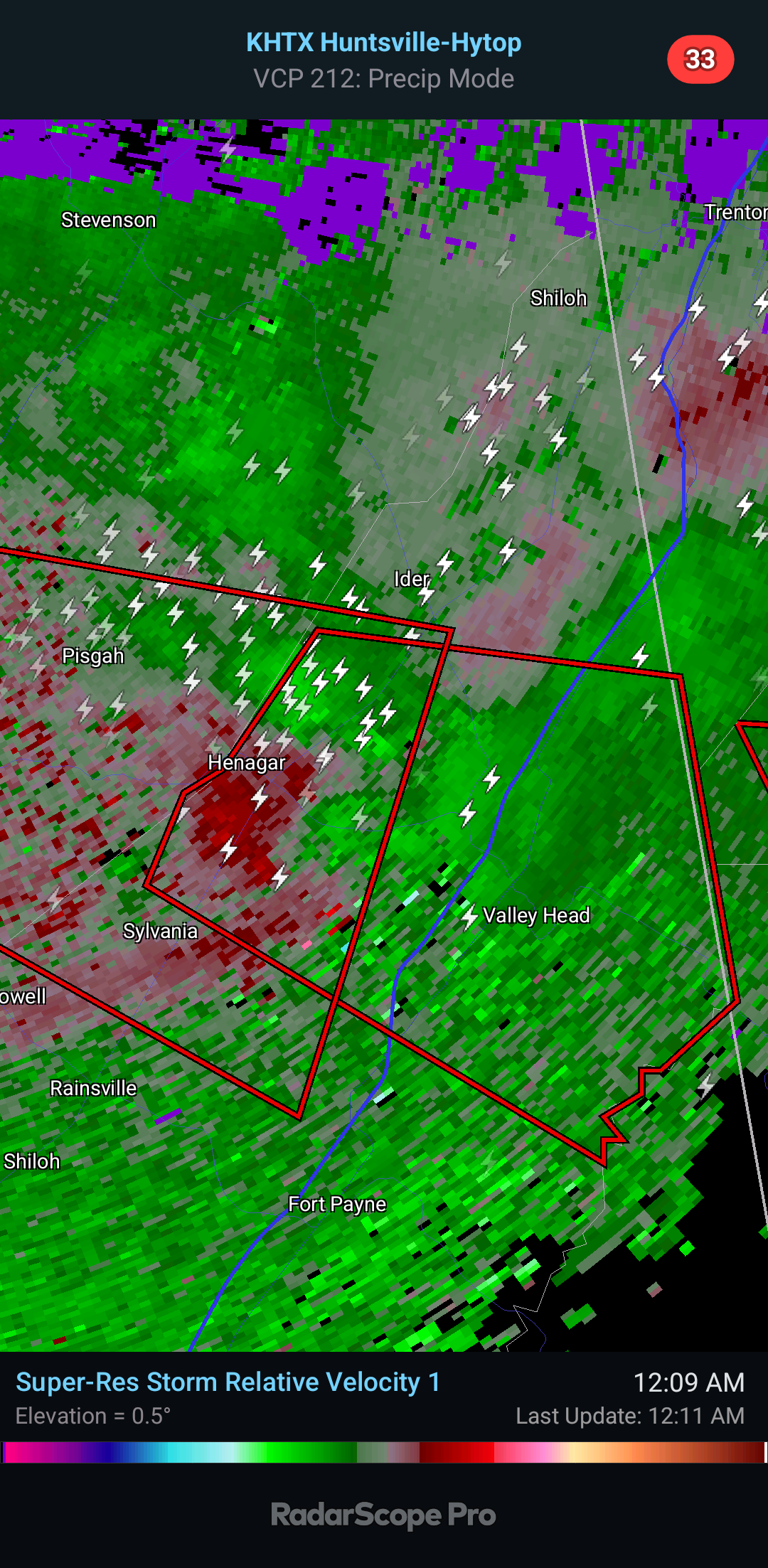
11:38 - New tornado warning again for Scottsboro, Pigsah, Hollywood, Dutton, Section, over to Sylvania and Henagar. In or near any of these locations, anywhere in the polygon, get to a safe place and stay there. Don't fool around tonight. These storms mean business.
11:40 - That especially dangerous looking tornado is moving out of Dekalb County soon and over into Georgia. Any readers over there, if you find yourself in this polygon, please be sheltered and take the best precautions you possibly can. Ideally if you can get to a storm shelter, I would for a tornado with a history like this one.
11:42 - About to shift focus to the Scottsboro storm since the other one is crossing over into Georgia.
11:45 - Anywhere in this polygon, places like Pigsah, Dutton, all the way to Sylvania and Henagar again, need to take shelter and stay there.
If anybody is going to Henagar for cleanup and rescue, please be aware another storm with a tornado warning is moving in that direction. Anywhere in this polygon, take your tornado precautions.
11:52 - This tornado warning is the only one left in Alabama now. The other one is well into Georgia. We'll hand it off to them. This one has multiple circulations showing up within the polygon, one is getting very close to Pisgah. But everyone in the path of this, in the polygon, stay sheltered until the warning is let go for you. We've had major damage today and tonight, don't need to take chances with what we've got left.
11:59 - This is the last tornado warning we have on the board. The circulations are coming and going within this polygon, so I would respect it and stay sheltered.
12:04 AM THURSDAY MAY 9TH - Zooming out, we are having Flash Flood problems in and around Huntsville, also in many parts of Tennessee including in and around Winchester. Will catch up with that stuff later. We had a barrage of tornadoes tonight and until that has wound down, gotta' focus on that threat.
12:12 - Now this Tornado Warning has been extended over to the Georgia state line.
Places like Henagar, Valley Head, Mentone, Hammondville, Desoto State Park need to take shelter again. Stay sheltered until this passes. This thing keeps having tornadic circulations, and the last thing we need is for someone to survive one tornado and then get hit by another unprepared. That has happened in weather history. So please spread the message however you can if you know anybody up that way. Hopefully with rescue workers already there, word will get around even in places the power may be out or whatever.
Just to be clear, any tornado we have here would probably be more of a "quicker spinup", not seeing signs of a significant tornado like the last one was. But any tornado is dangerous. And we have to treat each storm seriously.
12:19 - Let's take some inventory. The yellow are counties still under a Tornado Watch until 3 AM. I misspoke earlier saying it was 4 AM.
The red of course is the Tornado Warning.
The brown are all Flash Flood Warnings. The flooding is pretty crazy up in Tennessee. But also affecting Huntsville. When I say crazy I just mean widespread.
That storm, the orange over in Georgia is where the storm has been downgraded to a Severe Thunderstorm Warning with a note that a tornado is possible. That's the one that did major damage in Henagar over on the Alabama side.
As to whether we could still see more severe weather overnight through the morning, that's a tough question. Right now much of North Alabama has been cleared from the Tornado Watch. But more storms are to our North and West. The risk for severe weather will likely be a lot lower when they do get here in a few hours, but something isolated could still reach severe limits. As far as any really "particularly dangerous" storms like we've seen earlier tonight, I doubt we see any more of those. But to be on the safe side, I would sleep with your weather radio on alert.
And actually now the Tornado Watch has been cleared for more counties in North Alabama and even a few in Southern Middle Tennessee.
Jackson and Dekalb Counties remain under it until 3 AM tentatively.
They will likely clear it after this Tornado Warning expires, the storm moves into Georgia.
Counties like Giles, Lawrence, and Wayne in Tennessee are covered by Nashville's office, not Huntsville's, and they have made a different decision as to how quick to cancel the watch. So that goes until 3 AM as well.
12:31 AM - This last tornadic storm is just Northeast of Valley Head, almost over into Georgia, moving generally East/Southeast.
12:48 - We are clear of any tornado warnings anywhere in North Alabama or Southern Middle Tennessee now.
WHAT A NIGHT.
We do have some flash flooding issues going on. I will make another post for those and try to assess any severe threat we may have later tonight into tomorrow morning. Well technically it is Thursday morning now, it's after Midnight.
12:53 - Can't resist chuckling at this. The SPC extended the Moderate Level 4/5 Risk into North Alabama and ended up issuing a 15% hatched tornado risk for far Northeast Alabama. I'm getting the feeling they did this after the tornadoes already started firing. Sometimes nobody gets the forecast exactly right.
Tornado Warning
ALC049-090445-
/O.NEW.KHUN.TO.W.0032.240509T0425Z-240509T0445Z/
BULLETIN - EAS ACTIVATION REQUESTED
Tornado Warning
National Weather Service Huntsville AL
1125 PM CDT Wed May 8 2024
The National Weather Service in Huntsville Alabama has issued a
* Tornado Warning for...
East central DeKalb County in northeastern Alabama...
* Until 1145 PM CDT.
* At 1124 PM CDT, a confirmed large and extremely dangerous tornado
was located near Henagar, or 10 miles northeast of Fort Payne,
moving east at 35 mph. This tornado has caused significant damage
in Henagar, AL.
This is a PARTICULARLY DANGEROUS SITUATION. TAKE COVER NOW!
HAZARD...Damaging tornado.
SOURCE...Radar and spotter confirmed tornado.
IMPACT...You are in a life-threatening situation. Flying debris
may be deadly to those caught without shelter. Mobile
homes will be destroyed. Considerable damage to homes,
businesses, and vehicles is likely and complete
destruction is possible.
* This tornadic thunderstorm will remain over mainly rural areas of
east central DeKalb County, including the following locations...
Hammondville, Mentone, and Valley Head.
PRECAUTIONARY/PREPAREDNESS ACTIONS...
To repeat, a large, extremely dangerous and potentially deadly
tornado is on the ground. To protect your life, TAKE COVER NOW! Move
to a basement or an interior room on the lowest floor of a sturdy
building. Avoid windows. If you are outdoors, in a mobile home, or in
a vehicle, move to the closest substantial shelter and protect
yourself from flying debris.
&&
LAT...LON 3451 8553 3456 8570 3465 8567 3468 8554
3454 8551 3453 8551
TIME...MOT...LOC 0424Z 271DEG 29KT 3460 8564
TORNADO...OBSERVED
TORNADO DAMAGE THREAT...CONSIDERABLE
MAX HAIL SIZE...1.00 IN
$$
30


.png)


No comments:
Post a Comment