FORECAST:
Friday (High 75, Low 63): Rain and thunderstorms likely. A few storms could be strong.
Saturday (High 78, Low 65): Mostly cloudy and breezy. Numerous rounds of rain and thunderstorms are still possible.
Sunday (High 83, Low 62): Mostly sunny. Warm.
EXTENDED OUTLOOK:
Monday (High 86, Low 60): Sunny.
Tuesday (High 89, Low 64): Mostly sunny.
Wednesday (High 87, Low 67): Partly cloudy with a 20% chance of showers/thunderstorms.
Thursday (High 88, Low 69): Partly cloudy with a 20% chance of showers/thunderstorms.
READING TEA LEAVES:
Friday May 24 (High 88, Low 68): Partly cloudy with a 20% chance of showers/thunderstorms.
Saturday May 25 (High 89, Low 68): Partly cloudy with a 20% chance of showers/thunderstorms.
PRONÓSTICO:
Viernes (Máxima 75, Mínima 63): Lluvia y tormentas eléctricas probables. Algunas tormentas podrían ser fuertes.
Sábado (Máxima 78, Mínima 65): Mayormente nublado y con brisa. Todavía son posibles numerosas lluvias y tormentas eléctricas.
Domingo (Máxima 83, Mínima 62): Mayormente soleado. Cálido.
PERSPECTIVA EXTENDIDA:
Lunes (Máxima 86, Mínima 60): Soleado.
Martes (Máxima 89, Mínima 64): Mayormente soleado.
Miércoles (Máxima 87, Mínima 67): Parcialmente nublado con un 20 % de probabilidad de lluvias/tormentas eléctricas.
Jueves (Máxima 88, Mínima 69): Parcialmente nublado con un 20 % de probabilidad de lluvias/tormentas eléctricas.
LEYENDO LAS HOJAS DE TÉ:
Viernes 24 de Mayo (Máxima 88, Mínima 68): Parcialmente nublado con un 20 % de probabilidad de lluvias/tormentas eléctricas.
Sábado 25 de Mayo (Máxima 89, Mínima 68): Parcialmente nublado con un 20 % de probabilidad de lluvias/tormentas eléctricas.
Domingo 26 de Mayo (Máxima 88, Mínima 69): Parcialmente nublado con un 20 % de probabilidad de lluvias/tormentas eléctricas.
NOTES:
Here are the latest tornado surveys from last week.
The Huntsville and Lawrenceburg NOAA Weather Radio transmitters are currently off the air.
Update 10:25 PM - Huntsville is restored already.
It is sunny and 81 degrees in Cullman this afternoon at 3:15 PM. The dewpoint is 64, making the relative humidity 58%. Winds are variable at 7 miles per hour. The pressure is 29.91 inches and falling. The Low this morning was 55.
In Jasper, skies are sunny with a temperature of 84. The dewpoint is 68 degrees, making the relative humidity 58%. Winds are variable at 5 miles per hour. The pressure is 29.87 inches and falling. The Low this morning was 55.
Skies are fair with 81 degrees in Haleyville. The dewpoint is 63, making the relative humidity 54%. Winds are North at 9 mph. The pressure is 29.92 inches/1011.5 millibars and falling. The Low this morning was 55. Seems to be a popular number today.
It is partly cloudy and 81 in Huntsville. The dewpoint is 63, making the relative humidity 54%. Winds are variable at 5 mph. The pressure is 29.89 inches/1011.4 millibars and falling. The Low this morning was 59.
It is mostly cloudy in Nashville and 78 degrees. The dewpoint is 60, making the relative humidity 54%. Winds are from the North at 5 mph. The pressure is 29.91 inches/1012.2 millibars and falling.
We are temporarily under a ridge of high pressure in the Southeast/Tennessee Valley, with the big storms staying out West today and tonight, mainly out in Texas.
Tomorrow still looks rainy and sort of stormy as our next frontal system moves in, but the chance we'll see any severe thunderstorms seems to have diminished. We'll look at that below the main forecast discussion. Expecting a High of about 73-75 tomorrow, Low tonight of about 62-64 range.
Unfortunately the model guidance has gotten more consistent with the rain lingering into Saturday. I'm going to put the rain chance at 50/50 for any one spot Saturday, but mostly cloudy skies are expected with still a warm breeze. We could have some thunder still, but not expecting any problems with severe weather up this way. They could in Southeast Alabama, but that's way away from here. Expecting a High in upper 70's, about 76-79, and a Low near 65.
Then on Sunday, doubt we even see many lingering showers in the morning. Rain should be gradually tapering off through Saturday night as the system moves on out. High pressure will be moving into the Mississippi River Valley on Sunday. We'll be mostly sunny with a High about 80-84, Low near 60 or so.
Then Monday we have Northwest wind flow aloft, surface high pressure, and we'll have sunny skies. High should be in the lower to mid-80's and the Low near 60 again.
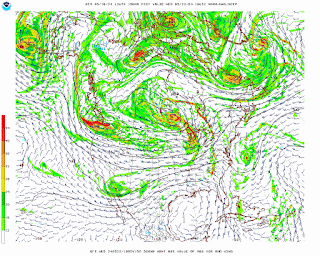
Tuesday the high pressure looks to be centered over Florida. And if you look at the upper-air map (that's the top one), you can see that we've come under a ridge in the Southeast. That means we'll get hot, this time of year, hot and dry. The models have backed off a little bit, but I still think we'll see upper 80's, at least about 86-87 for most of us, and the Low in the lower 60's.
On Wednesday we have another front coming our way, but it is going to run into that ridge of high pressure. So it's questionable how much moisture or rain we can squeeze out of it. We're getting into more of a summer pattern as we get closer to June. Going to cap the rain chances off at 20% here. Expecting a High in the mid-80's (could still be upper 80's, but let's factor in potential for clouds and maybe some passing rain) and a Low in the mid-to-upper-60's.
Then on Thursday of next week, going to keep that low-end rain chance of 20% even as it looks like the front washes out. We'll probably still see at least mid-80's overall and mid-60's for Lows.
Looking into the land of tea leaves, the GFS keeps some isolated rain around on Friday of next week. I'd still only put a 20% chance in the forecast, about like a summer day. High probably upper 80's, Low in mid-to-upper 60's.
If this guidance is right, then Saturday would be sunny with high pressure taking control again, High closer to 90, Low probably in the upper 60's.
I didn't show it before closing out that browser tab, but the ECMWF shows a wild scenario with a front and a bunch of rain coming in this next weekend (of May 24-26) and then clearing up. Doesn't ring true with this pattern. The GFS guidance is closer. But I may try a 10-Day Outlook here. And I'd guess another 20% rain chance day, like we'd have in early summer, and the temperatures I described.
And look, ten days out, the predictability just ain't that great. But the GFS does show a weak disturbance clipping us to the North. I believe the European model had us clearing up on Sunday from a huge bunch of rain. So given the overall pattern and this messy long-range model guidance, I'd go with another day of 20% rain chance, High somewhere close to 90 but maybe just upper 80's, and the Low near 70 or upper 60's.
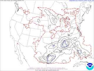
The NAM has backed off some on our severe weather parameters for the event tomorrow and tomorrow night. Oddly enough the one time that does still look pretty concerning is 4 AM Saturday. CAPE values of over 1,500 j/kg and Helicity values of more than 200 m^2/s^2, Significant Tornado Parameter of 2-4 range. If you take a forecast sounding in Cullman County at that time.
The SREF shows the most favorable time at 7 PM tomorrow (Friday). We've got CAPE values generally between 500-1,000 joules. Which is enough to work with. It's mainly over North Alabama rather than making it up into Tennessee counties. And the Helicity values get up to 200 or even 300 units, especially high in Northeast Alabama.
And it does show some supercell composite numbers ramping up, and you do see significant tornado parameter values ramping up to 4-6, but that's down in Southern parts of Alabama. In North Alabama or clipping the Tennessee counties, those values stay about 1-2 even at the times when it looks like the instability and wind shear will come together the best to support any storms becoming severe.
To be frank, the model guidance for this event has been a mess, not only over several days, but sometimes within the same 24-hour period. The Storm Prediction Center has mostly taken North Alabama out of the severe thunderstorm risk tomorrow, expecting a Mesoscale Convective System down near the Gulf Coast to cut off a better supply of moisture and unstable air up this way. They only have some of us outlooked for a 5% marginal risk of damaging winds now. The probabilities for large hail or for tornadoes are well to our South and are maxed out along the coastline. Even there, it just looks like a general isolated tornado threat for now, but might have some real hailers along parts of the Louisiana coast and the coast of Texas.
And if you zoom in on North Alabama, you can see that we are mostly now just outlooked for general thunderstorms tomorrow after all. The Marginal Risk does clip Cullman and Winston Counties, and it does include all of Walker County. But it is the lowest risk they can issue.
I'm going to defer to their judgement for the most part. But will still mention an isolated stronger storm being possible in the forecast just because of what a messy setup this is, that none of the models have done a good job with. For the most part, looking like just regular rain and thunderstorms up this way. If we were to get anything severe, it would be isolated and probably just some damaging wind gusts.
Trying to forecast this system has been humbling at times.
The better chances for heavy rainfall and flash flooding potential also look like they will be over South Alabama and into the Florida Panhandle.
Looks like most of us will see about an inch of rain for this forecast period, most of it tomorrow through Saturday. Places that do get heavier showers or more rounds of rain might see closer to two inches.


No comments:
Post a Comment