

FORECAST:
Tuesday (High 76, Low 63): Mostly cloudy and breezy. Numerous rounds of rain and thunderstorms are possible, and a few storms may produce hail and strong winds.
Wednesday (High 79, Low 61): Mostly sunny. Breezy.
Thursday (High 83, Low 57): Mostly sunny. Warm but with low humidity.
EXTENDED OUTLOOK:
Friday (High 78, Low 62): Rain and thunderstorms likely.
Saturday (High 81, Low 63): Mostly sunny.
Sunday (High 84, Low 61): Sunny.
Monday (High 83, Low 62): Mostly sunny.
PRONÓSTICO:
Martes (Máxima 76, Mínima 63): Mayormente nublado y con brisa. Es posible que se produzcan numerosas lluvias y tormentas eléctricas, y algunas tormentas pueden producir granizo y fuertes vientos.
Miércoles (Máxima 79, Mínima 61): Mayormente soleado. Ventoso.
Jueves (Máxima 83, Mínima 57): Mayormente soleado. Cálido pero con poca humedad.
PERSPECTIVA EXTENDIDA:
Viernes (Máxima 78, Mínima 62): Lluvia y tormentas eléctricas probables.
Sábado (Máxima 81, Mínima 63): Mayormente soleado.
Domingo (Máxima 84, Mínima 61): Soleado.
Lunes (Máxima 83, Mínima 62): Mayormente soleado.
NOTES:
The National Weather Service in Nashville has put together a good page about last week's severe weather event of May 8-9.
And the other night, I tried to compile the reports, including the surveys from North Alabama.
DISCUSSION:
We had an overcast day in the Tennessee Valley with periods of light rain. The High in Cullman was 68, and the Low was 61. Jasper had a High of 70 and Low of 63. And Haleyville had a High of 68 and Low of 61.


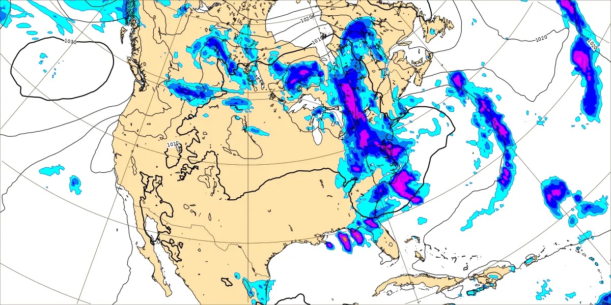
Most of the rain has stayed to our South today, along with some thunderstorms down toward the Gulf Coast.


The NAM keeps it across the TN border. Since I'm forecasting for Cullman, I'm taking the rain chances out completely. Skies should be partly to mostly sunny. High should rebound to near 80, maybe just shy of it in upper 70's, the Low near 60 or so.
And it'll still be breezy on Wednesday behind the front.


Definitely getting a break in the rain on Thursday in between two weather systems. Plenty of sunshine with a High in the lower 80's and a Low actually dipping into the upper 50's for one morning with such dry air.


Rain and thunderstorms are likely on Friday as the next front comes in. With one low pressure system up in Missouri and the other in Southern Mississippi, this is likely to be a heavy rainmaker than a severe thunderstorm event. And even the chance for excessive rainfall looks marginal until you get down into South Alabama. The GFS has really backed off on the idea of enough unstable air and wind shear coming together for severe thunderstorms up this way. We might end up with a low-end threat like tomorrow's. For now I'm going to take the mention of any severe thunderstorms out of the forecast. I think I got a little overly vigilant after that event last week that overperformed. We knew that was possible in Middle Tennessee, but a lot of us in North Alabama got a nasty surprise that evening and night. But this late-week system continues to look less threatening with regard to any severe thunderstorm potential. If that southernmost Low were to take a more northerly track toward about Memphis, that would spell severe weather potential for us. But it doesn't look like that is going to happen. And even the threat for heavy rain/flooding issues doesn't look too concerning for us up here. You always have to watch for that with multiple rounds of rain like we've had lately. And you always have to watch for severe storms in May. But overall I think Friday will just bring general rain and thunderstorms. We'll be sort of warm, High in the upper 70's, Low in the lower 60's. It wouldn't be impossible to see an isolated severe thunderstorm or a rogue instance or two of flash flooding in this neck of the woods. But overall I don't think that stuff is likely. And we do need the rain before we get into summer proper. As James Spann always notes, we need that moisture in the soil to keep us from getting excessively hot later on, when we get into July. So it's good if we get plenty of rain in May and June.


The weekend continues to be a headache, and it is an odd situation, flip-flop of how it usually is in the extended. The GFS wants to keep the rain slowly moving out of here on Saturday.
And it is the European model, the ECMWF, that wants to breeze it right on out of here. This model tends to be "sick" at this time range, as a lab instructor named Stephen Cantonwine once put it to me.
I'm going to compromise only slightly by keeping a 20% chance of lingering showers in there Saturday, a High in the lower 80's and Low in the lower 60's.


Then the GFS has come into agreement with the ECMWF about Sunday, keeping us high and dry. Again should see a High in the lower 80's and Low in the lower 60's.


And it looks like clear skies again on Monday with a High in the lower 80's Low in the lower 60's.

Rainfall totals up this way should be 1-2 inches over the next seven days. The higher totals where it could get concerning for flooding potential with 3-4 inches or more should stay in South Alabama and other parts of the Gulf Coast like the Florida Panhandle. So I think the rain we're getting this week is going to help us out more than cause us any more problems. I know a family that's just started a garden, and you know, this will help the crops out. May be adopting another cat soon. If so, perhaps I'll let you know how much she and Salem whup up on each other. We'll see.


No comments:
Post a Comment