Monday (High 74, Low 60): Mostly cloudy and breezy with scattered showers and thunderstorms possible. Rain will become more widespread at night.
Tuesday (High 77, Low 61): Cloudy and breezy with numerous rounds of showers and thunderstorms possible. A few storms may be strong, with gusty winds and small hail.
Wednesday (High 76, Low 60): Mostly sunny. Mild.
Thursday (High 80, Low 57): Mostly sunny.
Friday (High 78, Low 63): Thunderstorms likely - some could be strong.
Saturday (High 82, Low 62): Mostly sunny with a 20% chance of a shower or thunderstorm.
Sunday (High 84, Low 63): Mostly sunny with a 20% chance of a shower or thunderstorm.
Here are the latest tornado surveys from last Wednesday night/Thursday morning. More survey work is planned this week as weather permits and people from the offices have time to.
So the rain is moving through the Mid-South and approaching us in the Southeast and Tennessee Valley region already tonight. By the way, you should be tuned in to
Coyote J's Cemetery of Rock while reading this, as it is the only suitable soundtrack for this weather forecast tonight. It is the one radio show I can think of that beats Nights with Alice Cooper. Granted it's a close call.
They're having flash flooding issues in East Texas from the rain. For the most part it is plain old rain though. There's not even a whole lot of lightning until you get down close to the Gulf Coast, where the air is a little more unstable.
That is all along a warm front and North of it.
Skies have stayed sunny in Cullman today with a High of 77 and Low of 52.
More of those rain showers will be lifting North and Northeast into our area tomorrow. They will still probably be fairly scattered and off-and-on for North Alabama. About a 40% rain chance. Expecting a High of about 74, Low tonight of about 60.
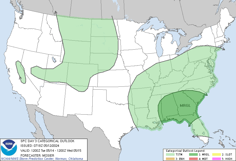
There is a chance for thunderstorms in the mix tomorrow, and even a chance some could reach severe limits, but that risk is very, very low up this way. If we do see a severe thunderstorm, it should be an isolated event.
Most of our rain may actually come Monday night into very early Tuesday morning.
The front will occlude on Tuesday and continue to push into the region. We'll have a rain chance of 50% then. So showers should be more numerous.
And again we could see some thunderstorms, even some stronger ones. Most should stay below severe limits, but one or two could try to get out of hand and produce some damaging winds and maybe large hail up to about quarter-size.
With that warm front pushing in first, temperatures could rise to about the 76-78 range, the Low still about 60 or so in the morning.
Both days should be breezy even outside of specific showers or storms.
We're probably not looking at wind advisory criteria though, just wind gusts more like up to 15-20 mph or so.
Then we get a break on Wednesday. High pressure will be moving in from the Mid-South behind the front. Should see a High in the mid-to-upper 70's and a Low still near 60. The chance of any lingering showers appears too low to mention in the official forecast, I'd say 10% or less. Expecting more sun than clouds, though at least early in the day, we could see times it's more of an equal mix.
Thursday also looks mostly sunny, with a High of about 80 or so, a Low down in the upper 50's again, with great radiational cooling conditions Wednesday night into Thursday morning.
Then on Friday we have another occluded front coming at us. And this time, we have a secondary center of low pressure that might end up in a favorable position to make this a severe weather setup. It is still five days out, so we'll just have to monitor the trends and see if it works out that way. It is tough to predict two systems in a row. By Wednesday when the first system is clear of our region, we'll see with a lot more detail what this Friday one is likely to do.
The guidance from the GFS has been all over the place, sometimes showing a scary setup of unstable air combining with good wind shear, other times going to the other extreme of basically showing nothing. But I'd keep in mind that we'll need to keep an eye on Friday's thunderstorms to be on the safe side.
Expecting a High in the upper 70's and a Low in the lower 60's.
For Saturday, the ECMWF has started to show a slower progression of the rain clearing out behind the front. I think the GFS is closer to being right and will only include a 20% chance of lingering showers here. Look for a High in the lower 80's and Low in the lower 60's. This cold front isn't going to pack much of a punch as far as temperature change.
On Sunday it is the GFS that brings another wave of rain in here while the ECMWF keeps us dry. So for both days next weekend I'm going to put a 20% rain chance in there but expecting mostly sunny skies with any lingering showers expected to be isolated. That fits the climatology for May and June better than just taking the rain chances out and totally second-guessing the models. Things tend to get unsettled the closer we get to the summer season.
Rainfall totals will probably average 1-3 inches for this forecast period in North Alabama. Central and South Alabama could see 3-5 inches or perhaps even higher amounts over the next week.
The chance of flooding issues is greater down that way, especially down around Mobile. The chance of flooding issues in North Alabama, at least with this first system tonight through Tuesday, is very low.
Well I wasn't able to see the lights from the solar storm either night. A friend told me we're not in a good position to see that kind of stuff, would need to be further out in the country where you've only got natural light in the sky to begin with.
Salem got his Sheba today, as he did yesterday. I think he is gradually learning that it is a weekend treat, and not a reason to bite me when he only gets dry food during the normal week. Cats these days can be so ungrateful though . . . I just don't know what the world's coming to.
The official forecast up top doesn't follow the SPC outlook exactly. I went more with my own judgement.


No comments:
Post a Comment