

FORECAST:
Tuesday (High 84, Low 61): Sunny. Mild.
Wednesday (High 80, Low 60): Mostly sunny. Mild.
Thursday (High 78, Low 57): Mostly sunny. Cool in the morning, mild in the afternoon.
EXTENDED OUTLOOK:
Friday (High 81, Low 59): Sunny.
Saturday (High 81, Low 61): Partly cloudy with a 30% chance of showers/thunderstorms.
Sunday (High 82, Low 63): Partly cloudy with a 30% chance of showers/thunderstorms.
Monday (High 84, Low 63): Mostly sunny with a 20% chance of showers/thunderstorms.
READING TEA LEAVES:
Tuesday June 4 (High 86, Low 64): Mostly sunny with a 20% chance of showers/thunderstorms.
Wednesday June 5 (High 85, Low 68): Partly cloudy with a 40% chance of showers/thunderstorms.
PRONÓSTICO:
Martes (Máxima 84, Mínima 61): Soleado. Leve.
Miércoles (Máxima 80, Mínima 60): Mayormente soleado. Leve.
Jueves (Máxima 78, Mínima 57): Mayormente soleado. Fresco por la mañana, templado por la tarde.
PERSPECTIVA EXTENDIDA:
Viernes (Máxima 81, Mínima 59): Soleado.
Sábado (Máxima 81, Mínimo 61): Parcialmente nublado con un 30 % de probabilidad de lluvias/tormentas eléctricas.
Domingo (Máxima 82, Mínimo 63): Parcialmente nublado con un 30 % de probabilidad de lluvias/tormentas eléctricas.
Lunes (Máxima 84, Mínima 63): Mayormente soleado con un 20 % de probabilidad de lluvias/tormentas eléctricas.
LEYENDO LAS HOJAS DE TÉ:
Martes 4 de Junio (Máxima 86, Mínima 64): Mayormente soleado con un 20 % de probabilidad de lluvias/tormentas eléctricas.
Miércoles 5 de Junio (Máxima 85, Mínima 68): Parcialmente nublado con un 40 % de probabilidad de lluvias/tormentas eléctricas.
Jueves 6 de Junio (Máxima 88, Mínima 69): Parcialmente nublado con un 20 % de probabilidad de lluvias/tormentas eléctricas.
NOTES:
It's going to take a while to go through all the damage reports around different parts of the country lately, but the town of Greenfield, Iowa appears to have taken an especially hard hit lately. The tornado was rated F-4 last I checked, and they were reviewing it all to make sure it didn't need to be upgraded to the rare F-5 category. (If you want to nitpick, you can call it an EF-4, but I don't think an extra letter makes any difference. So the scale was "Enhanced" several years ago. Big deal. They're working on improving it more. I think the extra letter is goofy.) And if you would like to make a donation to help them, you can do so here. A really trustworthy meteorologist referred me to that, since I generally do not trust charitable organizations to be truly charitable. A lot of them pocket the money, or at least I've seen evidence of that in the past. And if I'm going to donate to people I don't know, I want to make sure that money actually helps them out in a real way. If anybody knows of ways to provide relief to other areas hit hard lately, please feel free to leave me a comment or send me an e-mail.
Also any feedback on my attempts at Spanish on here, I welcome feedback, even if it is critical. Maybe more if it is critical, so I know what mistakes I'm making and can work on them. I am not a native speaker, just always had a knack for it and let it fall by the wayside.


After the storms cleared out very early this morning, it has been a mostly sunny day in the Tennessee Valley, a little breezy at times with variable winds mostly shifting back around to the West/Northwest. At 4 PM in Cullman it is 84 degrees, look like that may be our High, had a Low this morning of 66. The High was 90 in Jasper with a morning Low of 68. I think it's safe to say we're done with our severe weather season now and basically into summer, even if the calendar will take a little while to catch up to that idea. Looks like the current temperature of 84 will be the High for Haleyville, had a Low of 66 this morning.
Then Huntsville, where it got really stormy overnight, looks to have a High of 87, at least that's the current temperature and the High so far today. Their Low this morning was 66.
And Nashville has had a few more clouds hanging around. Looks like a High of 84 and Low of 64 there.
The rain has moved well to our South/Southeast. And the cold front is now passing through the region.


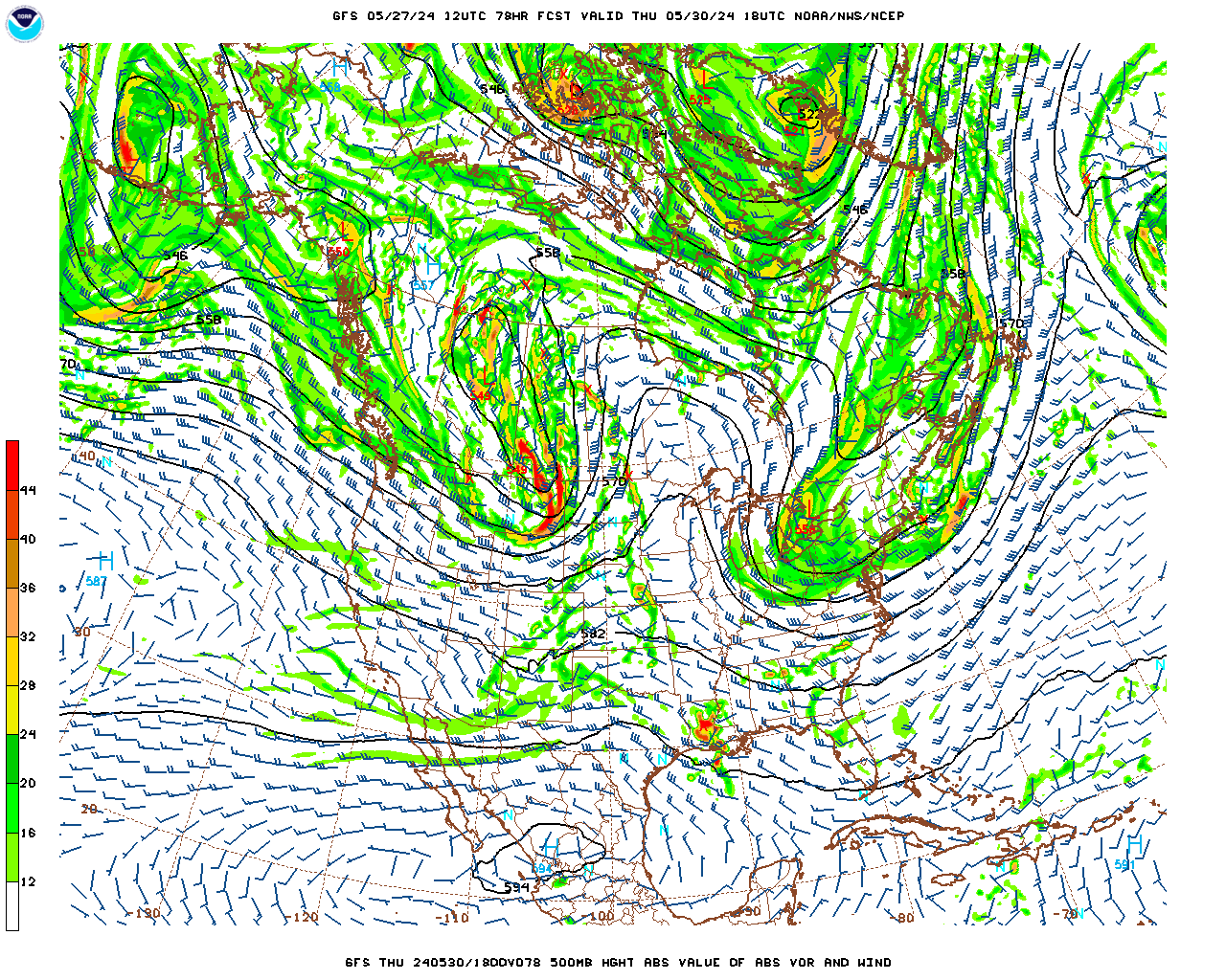
Tomorrow we'll have Northwest flow aloft, surface High pressure in the Gulf. Expecting sunny skies, a High of about 83-84, Low in the morning to start the day about 61-62.


Looks like a weak shortwave trough pushing through on Wednesday, but not expecting rain with it, just a slight increase in clouds at times, and then Wednesday night into Thursday, it is going to bring us a reinforcing shot of cool, dry air.
During the day Wednesday, skies should stay mostly sunny with only a few fair-weather clouds, High near 80, Low near 60.


And I really don't think that's right. The NAM does not go on this wild goose chase.

And neither does the European model, the ECMWF. It keeps us dry.
And I'm only going to mention a slight increase in clouds for Wednesday and Thursday.
The High Thursday should be about 77-80 range and the Low about 56-59. Doesn't get any milder than that for the end of May.


Friday also looks dry, sunny skies, High of 80 or so, Low in the upper 50's. So again, can you ask for better weather at the end of May? Pretty comfortable.


Some low rain chances will return Saturday. Going to estimate the rain chance at 30% here. High of 80 or so, Low of 60 or so.


Then on Sunday, the American model continues to advertise isolated rain chances, mainly up across the Tennessee border.

While the European global model shows a mass of rain. It did for Saturday too, though I didn't show it above. I don't think this is right. Taking into account the time of year and our climatology, I think the GFS has more of the right idea. But the best idea seems to be to blanket both Saturday and Sunday with a 30% chance of rain.
The High temperature for Sunday should stay in lower 80's, Low in lower 60's.


Then for next Monday, confident in trimming rain chance back to only 20%. I think the European model is out to lunch this time in showing higher rain coverage. The High on Monday should in the lower 80's after a morning Low in the lower 60's.
No organized severe weather is expected for this forecast period, and our severe weather season is over. Actually this Saturday, June 1st, starts our hurricane season. And that is expected to be active, since we have record-warm ocean temperatures.

Rainfall totals for the next seven days should average an inch or less. But as we get into the summer months, it is really hit or miss, who gets a random bigger dump of rain and who stays dry as a bone.


In this pattern, with no high-impact weather expected, and getting into the summer season, I do feel okay about looking into the land of tea leaves. So here is next Tuesday where it looks like a front will be approaching through the Midwest and Mid-South. Usually we don't see many frontal passages here once we get into June, so this is sort of an interesting look.
Keeping only a 20% chance of rain in the forecast, High still in lower 80's, Low in lower 60's.


The GFS shows the front moving through next Wednesday with a lot of rain, so this time I think it is the global model that is out to lunch.
The ECMWF public domain graphics only run out to 7 AM Thursday . . .
You know what? I messed that up. The ECMWF shows the same look of a pretty decent chance of rain Wednesday before the front washes out Thursday.


Both models, the ECMWF and the GFS, agree the front will wash out here on Thursday of next week. So I'll trim the rain chance back to 20%.
While the two global models do agree on the front bringing a good bit of rain on Wednesday, I'm only going to increase the chance to 40%. You have to think about climatology too. And for early June, often the models get it wrong, where only the basic idea of an uptick in rain chances is justified. And at this time range, you have to defer to climatology, local climate, even more.
So best guess at this tea leaves time range is: 20% chance of rain Tuesday, High in lower/mid-80's, Low in lower/mid-60's.
Wednesday bringing the rain chance up to 40% so probably only mid-80's for the High again, but the Low in upper 60's from the rush of more moist air in here.
Thursday the rain chance comes back down to 20%, more standard for a summer's day. High temperature in the upper 80's, Low in the upper 60's.
Enjoy. (If you wish.)
The lady who donated Stormy (for any newcomers, that's a cat) to me came by to see her for a minute today. And almost burst into tears of joy at how much calmer and friendlier she is acting. She and Salem both turned their noses up at the wet food I saved for the holiday today though, because I gave them each half a can of sardines yesterday. Could be my imagination, but ever since I fed her sardines, that Stormy cat seems a lot more fond of me in general. I only give wet food on the weekend or holidays though. I like to pamper the felines but not totally spoil them. She and Salem bumped noses today without her walloping him. So I guess he was right, and I was wrong, about being able to gradually win her over. It is a gradual process though, can guarantee you that even as our weather is so much calmer, that girl will live up to her name a lot. Her name from the animal shelter was Sweetness, and the woman who had her donated to her (for Christmas), said that she should have been named Demon instead, her other cat lived in terror of this creature. And a news story was on about the scandal of Donald Trump with Stormy Daniels. Right after I'd been telling this woman about how two parts of my family had close calls with tornadoes that were rated strong enough to destroy most of even a well-built frame house, and how stormy it had been all over the country here late in the Spring season. So I decided to rechristen the gal Stormy Sweetness, because she was basically a sweetheart, but had a very stormy personality from (very obviously, never seen it so obvious with a pet) having an abusive home before however the Decatur shelter picked her up. My dude I've had since last summer is named Salem Nyarlathotep. It was a different neighbor who donated him to me, right after a thunderstorm knocked a big chunk of a tree and a transformer over on my place last year, and she started to name him Lucifer, but then decided he wasn't quite that mean, and went with Salem. She was a great neighbor, and I hate that she's moving out of here. But I heard from several people that her kids were really rough with this poor guy, just not knowing any better. And it took a while to soften him up. He still plays pretty rough or gets scared of odd things like me strumming the guitar. But I gave him his last name from a classic horror story that is also a poem by the same author. You can easily find it online, even read as audio, for free. But it's worth paying for in a book too. Even for people with short attention spans, which is basically all of us these days, it is a quick and easy read. And there is definitely a side to this cat that fits both names, Salem and Nyarlathotep. I have to admit, part of the charm was watching people try to pronounce his last name. I'm not even sure I'm saying it right.

So here is a picture from the other day, where Salem took over Stormy's top spot on the cat tower. That towel she is on was a comfort thing from her former home. Shortly after this picture was taken, I petted him. And he rolled around and tried to playfully swat and gnaw on my hands, purring. Then I petted her for just a second or two before she cried and bit me just hard enough to let me know to knock it off. She seems like she wants to engage in affection now but is still afraid to. Like she'll remember that she doesn't do that, doesn't let people pet her or scratch her ears. And then she hissed at him when he leaned down to look at her.
So I thought I'd insert something lighthearted in here since the weather is looking great for us after those storms.


Yesterday into today really did produce a lot of severe weather over a large chunk of the country. Numerous tornadoes in mainly Missouri and Kentucky, some of which looked like they were large and particularly damaging. There were several people killed in this event and also in Arkansas and back into the Plains. Here I'm not even showing the maps for the Saturday event that mainly affected the Great Plains, including parts of Texas.

Well why not? Here is what it did Saturday, just numerous reports of tornadoes, large hail, and damaging thunderstorm winds.
So the last three days have been rough, even if we only got the leftovers last night and early this morning. Technically I think all of ours happened after Midnight, so was part of early Memorial Day.
And I compiled the damage reports most relevant to us right around here into a separate post.
One troubling thing I saw was a report of a woman killed by a tree falling on a home in Jefferson County, Alabama. And I noticed two other fatalities further North, think one was in Benton County, Tennessee. The other one was in Kentucky, can't remember if it was related to straight-line winds or a tornado. And that's what I was afraid would happen with this event, the bad timing of it and how pathetic public awareness can be of these things. Like a lot of people don't even have a weather radio still. Neither outdoor sirens or Wireless Emergency Alerts usually go off for a Severe Thunderstorm Warning. And the outdoor sirens barely help any anyway. Unless somebody lives really close to one, they're not going to wake up in the middle of the night on a holiday to take cover. And usually when people are seriously injured or killed in an event like we had this time, it is something that could have easily been prevented, if they got the warning and took very simple precautions. Now once in a while, it's just terrible luck, like a tree can technically fall and kill someone every once in a while even if they do the right things. But being on the lowest floor away from windows, in a small space where the walls are a lot less likely to collapse, can save a life, even if it's from straight-line winds instead of a tornado.
So we probably won't have organized severe weather again until we get into November, or at least close to it. But keep these lessons in mind for later. If you're smart enough to read this far, I trust you to keep this stuff in mind.
And the weather looks great this week overall. Rain chances come back this weekend into next week, but it looks like typical early summer stuff, still a calm pattern that's typical for the time of year.


No comments:
Post a Comment