


10:05 PM - Okay and in addition to this, we have that tornado moving from Gurley and Paint Rock toward Scottsboro and Hollywood now. That is a strong hook echo, and this tornado was definitely down on the ground with damage earlier. Even up at Skyline, even down to Section, you need to be sheltered, everywhere in that warning polygon.
We still also have a Tornado Warning affecting Franklin County TN and further North in Jackson County AL. That's the tornado East of Huntland and South of Winchester, or at least strong rotation that looks like a tornado, could very well be producing one.
10:08 - And now Stevenson, Bridgeport, Shiloh, that part of Jackson County, go to your tornado shelter or the safest room in your home. Can't stay in a mobile home.
And now we'll look back at the storm that prompted this post. But so much is happening so fast tonight. Trying hard not to neglect the smaller communities by focusing too much on Huntsville.


10:10 - This possible tornado moving from Athens toward Huntsville, I wouldn't piss around with it. If you are in that warning polygon, the best thing to do is go ahead and get into a small room or hallway on the lowest floor of a sturdy house or other strong building. Try to be near the center of the building, definitely be away from any windows.
And you can't stay in a mobile home. Leave there for a sturdy building.
There is no way to know if it's on the ground at night a lot of times. We were lucky to get confirmation earlier. But sometimes we don't. And even if it's rotation in the air, it can come down to the ground really fast. It is not worth the risk. These are supercell thunderstorms producing tornadoes tonight. Pleas keep yourself and your loved ones safe.

10:16 PM - For what it's worth, a new Tornado Watch has been issued until 4 AM for counties in Northeast Alabama including Madison.
The old Tornado Watch is set to expire at 11 PM.
What a crazy event this is.

10:19 - We still have three active Tornado Warnings. That one in Jackson County will be moving into Georgia. But that warning goes for another 25 minutes. Sometimes these storms are moving kind of slowly tonight compared to how they usually do around here.

10:21 - This one moving toward Scottsboro, same one that produced a tornado in or near Huntsville, has a confirmed tornado again, debris signature showing up, and look at that hook echo.

10:24 - There's our debris signature, TDS.
10:26 - And we are down to two Tornado Warnings. That one further North in Jackson County weakened and was cancelled.
Everyone in Huntsville or near there, stay sheltered.
Also in or near Scottsboro, stay sheltered.


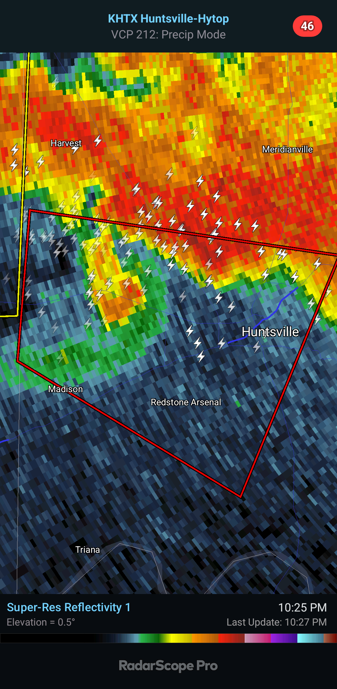
10:27 - Once again Madison, Huntsville, around Redstone Arsenal, UAH and the other colleges around there, stay sheltered. It pays to play it safe tonight.

10:30 - And that confirmed tornado with a history of damage (maybe significant damage) is coming at Scottsboro.
10:32 - The one moving into Huntsville has been riding along Highway 72. Nobody needs to be driving there. Need to pull over and get into a building.

It looks like it is tracking more North for now. But to play it safe, I'd rather everybody in Huntsville stay sheltered for the next ten minutes until we see who's in and out of the new warning. I assume they will reissue something when this expires soon.
Here's our new Huntsville warning.


10:38 - And sure enough it is tracking a little more North than it was. But still a similar path to the other one. Huntsville, Moore's Mill, Alabama A & M, Brownsboro are included in this new Tornado Warning.


10:41 - This one moving through Scottsboro may be more important. It has had a confirmed tornado earlier and is heading toward Pisgah.
10:44 - Looks like the Huntsville tornado is coming up Monte Sano again. I refer you to Brad Travis, who shows a rotating wall cloud on his skycam at the moment.

10:47 - New tornado warning for Jackson and Dekalb Counties now.

10:49 - The Huntsville tornado, or possible tornado, is taking almost the exact same track, coming over Monte Sano now.
10:50 - Broadcast media and National Weather Service noting funnel cloud with this, East side of Huntsville. This could come down to the ground at any moment.
10:51 - Also been watching Ryan Hall's stream. He's good, but sometimes when stuff gets real locally I trust the locals more. Tonight it's Brad Travis I'm watching.
Radar is good, but they've got all these cameras, it helps.


10:56 - So we're dealing with two tornadoes, or at the very least two storms trying to produce a tornado.

10:59 - Ryland, Maysville, Gurley remain in the warning polygon.
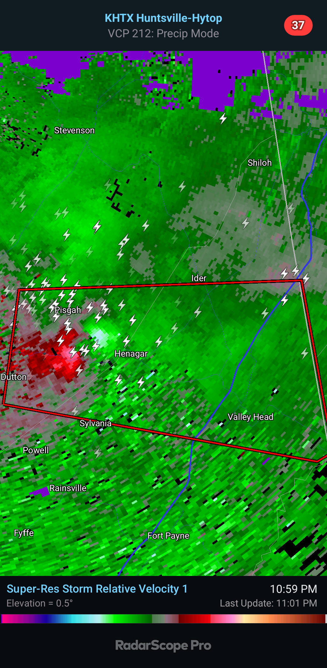
11:01 PM - Between Pisgah and Henagar, stay sheltered. All the way East to Valley Head need to be in a safe place for this other Tornado Warning affecting Dekalb County.
11:03 - Gurley Fire Department reports tornado along Highway 72 now.

Paint Rock, Pleasant Grove, Woodville, Aspel, be sheltered. Respect the polygon as Spann in Birmingham says. These things can change direction fast, and they draw these broad polygons for a reason.
11:06 - Now we've got debris signature for the Henagar tornado in Dekalb County. This could be doing really significant damage. Take maximum precautions - basement if you've got one. Small central room on lowest floor of strong house if not.

11:08 - If you are in a mobile home, GET OUT! Try to get into a sturdy building, but if the best you can do is an unflooded culvert or ditch or a low spot on the ground, lie there, covering your head with your hands, and back of your neck, as a last resort. You cannot stay in a mobile home with this. This looks like a powerful tornado.
Tornado Warning
ALC083-089-090345-
/O.NEW.KHUN.TO.W.0026.240509T0254Z-240509T0345Z/
BULLETIN - EAS ACTIVATION REQUESTED
Tornado Warning
National Weather Service Huntsville AL
954 PM CDT Wed May 8 2024
The National Weather Service in Huntsville Alabama has issued a
* Tornado Warning for...
Southwestern Madison County in north central Alabama...
East central Limestone County in north central Alabama...
* Until 1045 PM CDT.
* At 954 PM CDT, a severe thunderstorm capable of producing a tornado
was located over Athens, moving east at 30 mph.
HAZARD...Tornado and ping pong ball size hail.
SOURCE...Radar indicated rotation.
IMPACT...Flying debris will be dangerous to those caught without
shelter. Mobile homes will be damaged or destroyed.
Damage to roofs, windows, and vehicles will occur. Tree
damage is likely.
* This dangerous storm will be near...
Athens around 1000 PM CDT.
Madison around 1005 PM CDT.
Huntsville and Redstone Arsenal around 1015 PM CDT.
University Of Alabama In Huntsville around 1020 PM CDT.
Marshall Space Flight Center around 1025 PM CDT.
Other locations impacted by this tornadic thunderstorm include French
Mill and Capshaw.
PRECAUTIONARY/PREPAREDNESS ACTIONS...
TAKE COVER NOW! Move to a basement or an interior room on the lowest
floor of a sturdy building. Avoid windows. If you are outdoors, in a
mobile home, or in a vehicle, move to the closest substantial shelter
and protect yourself from flying debris.
Tornadoes are extremely difficult to see and confirm at night. Do not
wait to see or hear the tornado. TAKE COVER NOW!
&&
LAT...LON 3477 8700 3485 8696 3478 8653 3458 8663
TIME...MOT...LOC 0254Z 288DEG 25KT 3478 8693
TORNADO...RADAR INDICATED
MAX HAIL SIZE...1.50 IN
$$
70/DD


No comments:
Post a Comment