

FORECAST:
Wednesday (High 86, Low 69): Partly cloudy with scattered showers and thunderstorms possible during the day. Rain is likely at night.
Thursday (High 87, Low 67): Partly to mostly cloudy. Widely scattered showers and thunderstorms are possible.
Friday (High 80, Low 63): Sunny. Milder and drier air.
EXTENDED OUTLOOK:
Saturday (High 84, Low 59): Mostly sunny.
Sunday (High 85, Low 63): Partly cloudy with a 30% chance of showers/thunderstorms.
Monday (High 85, Low 65): Partly cloudy with a 40% chance of showers/thunderstorms.
Tuesday (High 87, Low 66): Mostly sunny with a 20% chance of showers/thunderstorms.
BEACH FORECAST:
Wednesday (High 85, Low 78): Partly cloudy. Widely scattered showers and thunderstorms are possible.
Thursday (High 86, Low 77): Mostly cloudy. Numerous showers and thunderstorms are possible.
Friday (High 88, Low 77): Partly cloudy. Widely scattered showers and thunderstorms are possible.
Saturday/Sunday (High in upper 80's, Low in mid-70's): Sunny.
Monday/Tuesday (High in mid-to-upper-80's, Low in 70's): Partly cloudy with a 40% chance of showers/thunderstorms.
IMPORTANT NOTE:
This does not have to do with local weather, which is pretty calm right now, but does matter for public safety.

A fugitive by the name of Rodney Dale Kilgore has recently been seen in Cullman, Alabama. (Clicking that sentence will take you to a local news story about it, for those who didn't figure it out on their own.) This picture is the one that is commonly being passed around right now by local media outlets, whether it's local papers in Cullman County or television stations in Birmingham and Huntsville.
The media is not mentioning the details of his crimes, only calling them felonies, last I saw. He is a confirmed sex offender, and I consider him a particularly dangerous one. Let's leave it at that.
I wasn't going to mention this publicly at first, was only talking about it privately to a few people, but since the press has jumped all over it today, I'm going to mention it and urge people to take the situation seriously.
The important thing is that this criminal be caught as soon as possible, before he has a chance to do further harm.
If you would like to see more pictures of him, do a search through the Georgia Bureau of Investigation. You can leave all other fields blank, just look up "Rodney Kilgore".
A regular search engine might also turn up one or two extra pics if the middle name ("Dale") is included, but I'd recommend the link I gave above.
The picture that was released above through the media, some crediting it to the Cullman Police Department, others crediting it to the U.S. Marshals, most closely matches the descriptions I have been given of the fugitive by word of mouth. But the GBI has a handful of pictures of him, with and without glasses. And this may help the more diligent to identify him.
If anybody has better advice than what I'm giving here, feel free to let me know by e-mail or by a comment, but here's what I would do if I saw someone I thought was this fugitive:
Try to remain calm and look as though you are going about your business, but (subtly) look the guy over, memorize as many details as you can of his appearance.
Get to a safe place out of earshot, and immediately call 911, or if you are in Cullman County, you might call the police department directly at (256) 734-1434 if it's during normal business hours. But if you don't have their number saved, let's face it, 911 is quicker. And everybody remembers that number. It started in Haleyville, as most of you probably know.
Make sure you know where you are. If you're near a store or other well-known landmark, of course that helps. But if you can give the cops a street name, or if you are near an intersection somewhere, that can really help. And if you can remember in what direction the guy was walking, small details like that might end up counting for something.
And above all, be safe. Just like with a tornado, your first priority is not to get blown away or injured by debris, more than reporting it to the Weather Service. With this, your safety and the safety of your family or whoever you're with, friends, loved ones, should be top priority.
In the same breath, we will all sleep easier once this despicable criminal is off the streets (or the backroads . . . I don't presume to know where he is). So any information you have, call the Cullman Police Department and tell them what you know. Be honest. If you are uncertain about details, admit what you're not sure about. If you see this guy, I'd go with 911. But again, make that call at a safe distance, and so that the fugitive cannot hear the call.
It can be scary to see someone who's been reported on the news to be a fugitive like this, and that's why I say, for whoever spots him somewhere: Try to remain calm, sort of like if you get goosebumps when you walk past a graveyard, just kind of let that feeling ride for a few moments and keep moving. And as soon as you can safely and discreetly do so, call 911 or the Cullman PD. And give them as much detail as possible about his appearance, where he was, and which way he was headed. On the off-chance he's in a vehicle, try to take down the license plate number into your cell phone or if you have something handy to write with, old-fashioned pen and paper. Or at least note the color and design of vehicle.
That's what I would do. If you have family or friends who are in law enforcement, maybe their advice will be better. But I felt obliged to offer what advice I can. I do not take things like this lightly. And I am aware that in dangerous situations, sometimes adrenaline takes the place of logic. So I am urging everyone to keep a cool head about this and do the right things, while also having a healthy respect for the real danger it does pose when you've got a guy like this still running loose.
Please spread the word about this dangerous criminal and let people see at least the one picture until he is caught and behind bars again. If my instincts are worth anything, he is really bad news.
It was a mostly sunny day in the Tennessee Valley with only isolated rain across the maps. The High in Cullman was 84, after a morning Low of 69. The High was 83 in Haleyville with a Low of 69. The report from Bevill Field in Jasper is not available at the moment. Fort Payne saw a High of 86 (or 85.5, but I rounded up) and Low of 65. Huntsville had a High of 85 and a Low of 72. Nashville saw a High of 82 and Low of 71.


And this MCS is weakening as it moves through here. These are just general airmass thunderstorms at this point.
Or as Chuck Doswell had a habit of calling them, "bird fart thunderstorms."
Seriously, it is nice to have some regular summer rain after such an active May to end our severe weather season.


Tomorrow a cold front will push toward the region. And we'll see an uptick in rain chances ahead of this front. During the day, rain should still stay scattered, but tomorrow night, rain is likely. High should be about 86, Low about 69, a mix of sun and clouds, maybe a few more clouds than an average day this time of year. And of course the air is unstable enough to support a few thunderstorms.


The latest run of the GFS is showing us pretty much clearing out by early Thursday afternoon, the front down near the Gulf Coast already.
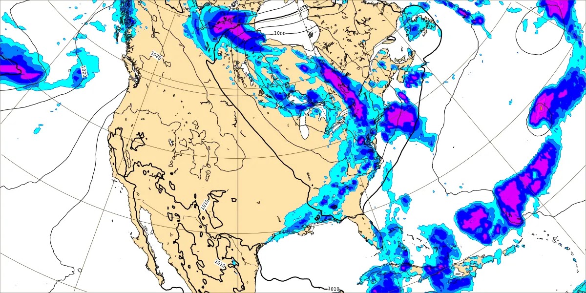
The ECMWF shows a slower progression. So will keep widely scattered showers in the forecast, a High about 86 again, Low about 66-68 range because of air being moist but also kept cooling by the overnight rain.


Then behind the front, we'll have high pressure moving in on Friday. And skies will be sunny. High of only about 80 or so, the Low in the lower 60's as much drier air moves in for a few days.


Then on Saturday, that disturbance bringing rain around Memphis during the day shouldn't bother us until the night hours if it's going to, even then rain chances look very low, isolated rain like you get in summer, about a 20% chance. During the day here Saturday should stay mostly sunny, a High in the lower 80's and a Low near 60, maybe even dipping into upper 50's for many of us.


And it looks like that shot of dry air only lasts a couple days, then Sunday we have another disturbance moving into the region. Should bring back rain chances of about 30-40% with a High in lower 80's, Low in lower 60's. These temperatures are still not bad for early June.


If only going by model guidance I'd bump the rain chance on Monday up to 40-50% range with a High near 80, Low in upper 60's or near 70. But the models are probably overdoing this. Probably better to keep rain chance on Sunday/Monday in the 30-40% bracket and only adjust temperatures a little bit according to that and lean toward climatology.


Then next Tuesday, will cop out to climatology even though global models want us clear here, will forecast a 20% chance of rain. And I haven't decided on the temperatures, will depend on what I do for the previous two days and just tweaking it. Not going to bother with a 10-day forecast this time. If I was, I'd probably just blanket a 20% chance of rain for days 8-10 with partly to mostly sunny skies, Highs in the mid-to-upper-80's, Lows in similar range in the 60's.
Nothing is going on in the tropics, and the social media hype over the GFS model is nonsense, as James Spann explained in detail in his video discussion this afternoon. He has more patience than I do, taking the time to explain why it's not worth worrying about. Short version is you don't go with wild goose chase scenarios from long-range deterministic global models when trying to forecast hurricanes. Follow the National Hurricane Center and read their discussions. They take many models and ensembles into account, and computer model data is not the only factor in their forecasts either. If you follow their discussions through even one hurricane one year, you'll see how complex it is. And there is no need to worry about this hype over global models showing unlikely scenarios, especially if it's only showing up on the GFS.

Rainfall totals will average about an inch over the next seven days, but the rain of summer, even early summer, tends to be randomly distributed, so these are even more an estimate than in more active seasons where the weather is more organized.
Stormy, the new cat, swatted at me so hard the other night she fell plumb off the cat tower. It was rather comical, as she landed on her feet and was okay. She turns hostile again whenever Salem comes into the room and gets close to her. She is less afraid overall and lets me pet her more, but it is uneven. She goes back and forth a lot. Salem is playing fetch with these springy toys that Stormy's previous owner brought over along with her other stuff. And he still seems to think he will eventually get the other cat out of her grouchiness. Time will tell . . .


No comments:
Post a Comment