

FORECAST:
Friday (High 83, Low 64): Sunny. Patchy fog possible in the early morning, otherwise low humidity.
Saturday (High 85, Low 58): Mostly sunny. Low humidity.
Sunday (High 87, Low 65): Partly to mostly cloudy. Scattered thunderstorms are possible - a few could be strong.
Monday (High 85, Low 65): Partly cloudy. Widely scattered showers and thunderstorms are possible.
Tuesday (High 83, Low 60): Mostly sunny. An isolated shower or thunderstorm is possible.
EXTENDED OUTLOOK:
Wednesday (High 86, Low 63): Partly cloudy with a 20% chance of showers/thunderstorms.
Thursday (High 88, Low 66): Partly cloudy with a 20% chance of showers/thunderstorms.
Friday June 14 (High 90, Low 68): Partly cloudy with a 20% chance of showers/thunderstorms.
Saturday June 15 (High 89, Low 70): Partly cloudy with a 30% chance of showers/thunderstorms.
Sunday June 16 (High 90, Low 72): Partly cloudy with a 20% chance of showers/thunderstorms.
BEACH FORECAST:
Friday (High 86, Low 76): Sunny.
Saturday (High 86, Low 73): Sunny.
Sunday (High 87, Low 77): Sunny.
Rest of Week (Highs in mid-to-upper 80's, Lows in mid-70's): Partly cloudy with a 40% chance of scattered showers and thunderstorms.
PRONÓSTICO:
Viernes (Máxima 83, Mínima 64): Soleado. Posible niebla dispersa a primera hora de la mañana, en caso contrario humedad baja.
Sábado (Máxima 85, Mínima 58): Mayormente soleado. Baja humedad.
Domingo (Máxima 87, Mínima 65): Parcialmente a mayormente nublado. Es posible que se produzcan tormentas dispersas, algunas podrían ser fuertes.
Lunes (Máxima 85, Mínima 65): Parcialmente nublado. Es posible que se produzcan lluvias y tormentas eléctricas ampliamente dispersas.
Martes (Máxima 83, Mínima 60): Mayormente soleado. Es posible que se produzcan chubascos o tormentas aisladas.
PERSPECTIVA EXTENDIDA:
Miércoles (Máxima 86, Mínima 63): Parcialmente nublado con un 20 % de probabilidad de lluvias/tormentas eléctricas.
Jueves (Máxima 88, Mínima 66): Parcialmente nublado con un 20 % de probabilidad de lluvias/tormentas eléctricas.
Viernes 14 de Junio (Máxima 90, Mínima 68): Parcialmente nublado con un 20 % de probabilidad de lluvias/tormentas eléctricas.
Sábado 15 de Junio (Máxima 89, Mínima 70): Parcialmente nublado con un 30 % de probabilidad de lluvias/tormentas eléctricas.
Domingo 16 de Junio (Máxima 90, Mínima 72): Parcialmente nublado con un 20 % de probabilidad de lluvias/tormentas eléctricas.
PREVISIÓN DE PLAYA:
Viernes (Máxima 86, Mínima 76): Soleado.
Sábado (Máxima 86, Mínima 73): Soleado.
Domingo (Máxima 87, Mínima 77): Soleado.
Resto de la Semana (Máximas entre 80 grados mediados y 80 grados superiores, Mínimas a mediados de 70 grados): Parcialmente nublado con un 40 % de probabilidad de lluvias y tormentas eléctricas dispersas.

We had a couple tornadoes in North Alabama yesterday along with the damaging thunderstorm winds, thanks to that cold front that hung together, as few do in the summer months around here.
Here is some information about staying safe in rip currents. It's that time of year for beach trips again.
This hurricane season is expected to be above average, so it is a good time to go over your safety plan.
This recent debate between Richard Dawkins and Ayaan Hirsi Ali is as good a summary of the state of our culture wars as I've seen. All things considered, it was respectful. There is a little vulgar language in it, but no more than the average person hears hanging out watching a ball game on the weekend. Now that I think of it, it's probably less than that. And I really liked it because it was a rational discourse between two friends who strongly disagree on some things. I don't know about the rest of you, but I find truly respectful, honest disagreements to be something of a novelty these days.

And the police search continues for Rodney Dale Kilgore, a fugitive from Georgia who was recently seen in Cullman. If you see this man, call 911 from a safe and discreet location, and give the cops as much detail as possible. I agree with other locals who consider him to be particularly dangerous, not someone a family man would want left alone with his family, is the only tactful or classy way I know to state it.
As usual, there may be errors in the Spanish version of forecasts. If somebody catches one and wants to help out, feel free to leave a comment or send me an e-mail.
DISCUSSION:


We had a fair amount of clouds in the Tennessee Valley through much of the day, few showers left over this morning, but then the sun broke out in the afternoon and evening, and the clouds diminished.
The High in Cullman was 83, and the Low this morning was 68. Jasper saw a High of 86 and Low of 68. Haleyville had a High of 84, Low of 66. Fort Payne had a High of 83 and Low of 68. Decatur saw a High of 86 and Low of 70. Huntsville had a High of 85 and Low of 70. Muscle Shoals had a High of 88 and a Low of 70. It's really feeling like summer in Tupelo, High of 90 and Low of 72 today. Memphis had a High of 88 and Low of 71. And it was actually pretty soupy in Nashville, High of 89 and Low of 72.
The cold front is pretty much through our area this evening, and they've got some stronger thunderstorms down in the Florida Peninsula. But our skies have cleared. And we'll enjoy some drier air tonight through the next couple days.


High pressure will be centered on the Mid-South tomorrow. Our winds will be light and out of the North. Sunny skies, High should get up to about 82-83 after a morning Low of about 63-64. We could see enough lingering moisture for some patchy fog overnight.


We'll stay mostly sunny on Saturday with a High in about the 84-86 range and a Low in about the 58-60 range. It's not all that often we have such cool mornings in early June, so if you like that kind of stuff, enjoy.

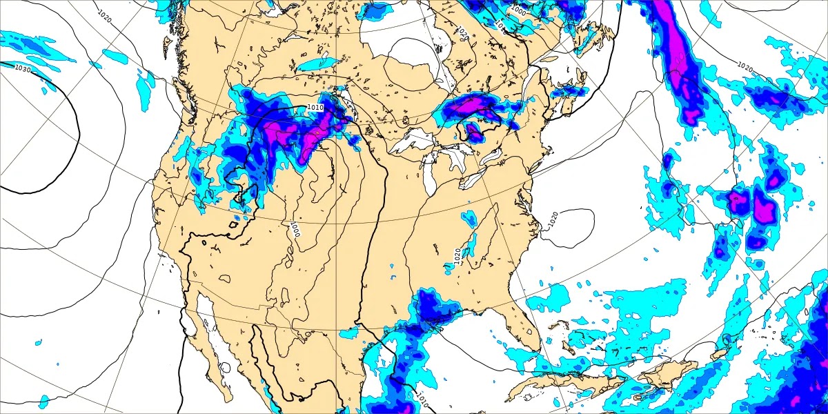
On Sunday we have another front coming our way, and the raw model guidance between the GFS/ECMWF was kind of a mess, with the European solution being a lot slower. So I'm just showing the basic idea here on the WPC maps, standard weather map showing the front and the center of low pressure. We'll have to watch for a mesoscale convective system coming out of probably Kansas or Missouri, where strong thunderstorms could sustain into North Alabama and/or parts of Tennessee.
It looks like our High will be in the upper 80's by this time, the Low in the mid-60's. I'll put the rain chance at 40% which just means scattered showers and thunderstorms across the map. Chance of any one spot around here getting a shower or storm about 2 out of 5.

This continues to look like we'll get another frontal passage, somewhat anomalous for the month of June, but I guess it's early in the season yet, and I'll keep an open mind here.
At this point, the best way I know to second-guess the mess the models have shown lately for Monday is forecast a 30% chance of rain and a High in the lower-to-mid-80's, a Low in about the mid-60's.


On Tuesday it looks like we get another shot of drier air, but not as pronounced as the one we'll get to start off this weekend. Looks like keeping a 20% chance of rain in the forecast is reasonable and forecasting a High in the lower 80's, Low near 60. A few places could see upper 50's again.


High pressure will take hold again by Wednesday. But let's not forget what time of year it is. And instead of splitting hairs and comparing global model guidance (the ECMWF does show rain chances here, where the GFS shown above, doesn't), I'm defaulting to climatology. Forecasting a 20% chance of rain again for Wednesday, which is that most typical isolated rain chance you see in the summer months. High should be in the mid-80's and the Low about 60 or so.


Then Thursday, basically the same thing, only the minimal 20% chance of isolated showers and thunderstorms, typical for this time of year, High in the upper 80's and Lows trending more toward the upper 60's again.

Summer rain is so hit-or-miss, but overall our rainfall totals should average less than a quarter-inch in Tennessee counties for the next seven days, less than a tenth of an inch for us in North Alabama.
And since this pattern is not a wild ride like we see in the Spring months, let's take a look at Days 8-10, what a 10-Day-Outlook would be for this setup.


Next Friday looks like the same pattern continues. The GFS keeps us dry, which isn't quite right.

The ECMWF shows more rain in here, which is closer to being right.
The only sensible forecast here, looking at both of the models sort of out to lunch and thinking about this pattern and our local climatology, is about a 20% chance of rain, and just a hot, humid day like you'd expect overall, High getting at least close to 90 and Low approaching 70.


There continue to be hints that we could get a little more Gulf moisture available, so will increase rain chance to 30% for next Saturday, still a High in upper 80's, Low near 70. That's still within the typical summer range, and it's only an educated guess. If you've lived around here even a year or two, you know how hit-or-miss our summer rain and storms are. Most days you're just gonna' swelter if you spend a lot of time outside. The humidity here makes it a lot rougher than say, out in Texas, and that's why a lot of people here get sick. Or I hate to be morbid here, but it never fails, every year we hear at least a story or two of people leaving their pets (or worse, their actual human children) in a hot car, coming back, and finding them victims of heatstroke . . . seriously, sometimes they are dead. So I'm just throwing that in. Overall summer is a quiet season for us. But let's not invite tragedy where there doesn't need to be any. And when things like this happen, usually it's just that people get in a hurry and don't think about it, sort of like they drive into flood waters. Somebody might think it's okay because they're only leaving a kid out in the back seat of a car while they grab a few snacks for five minutes. And then something comes up, they get held up in a line or talking to an old friend, meanwhile that car gets really hot. I've heard some meteorologists blow that off, like we can't force people to have common sense. But I agree with what John Gordon (works in Kentucky now, but helped Bud Cramer found the modern National Weather Service office in Huntsville back in 2003) came up with, sort of a campaign of: "Beat the heat - check the back seat!"
Just to be clear, there are no signs of unusual heat coming up even in this super-extended-forecast-period. But we haven't had time to get used to the heat this year. So just a reminder to look out for your loved ones. Another sensitive group is old folks. You don't want Grandma to get a heatstroke either . . . that's worse than getting run over by a reindeer at Christmas time. So a little common sense goes a long way.
And that's a worst-case scenario. Usually people just get a little bit sick, heat exhaustion. But I wouldn't risk leaving somebody in a hot car when it gets close to 90 degrees and we've got the kind of humidity we get every year around here. Sometimes the worst does happen, and a moment or two of thought will prevent any chance of something like that. The only reason I spend some time on it is that frankly, it sort of gets old year after year, seeing stories about that stuff. People keep doing it.


And a 20-30% chance of rain, High near 90, Low near 70 looks right for next Sunday too, the 16th of June.
The GFS keeps wanting to develop a tropical disturbance in the Gulf of Mexico, but it changes the timing and placement of it. It is notorious for showing stuff like this every year that almost never happens.
The ECMWF is not on board with that idea anyway. And that's usually how it goes.
We know it'll probably be an active hurricane season, some think even similar to 2020. Sometimes it's August before things really crank up. It's okay to keep an eye on model trends, but don't get hung up on wild goose chases (which the GFS is well known for) at days 7-10 or beyond, that's just silly.
And to close this out, I'll just note that Stormy, the new tabby cat, spend a couple hours napping with me today. At least she got some beauty sleep. She is softening up some. She cried a lot last night and this morning wanting out. But she hasn't been here long enough that I can trust her not to escape and run off. It is not the safest neighborhood for cats necessarily. We're supposed to keep all pets on a leash. Salem looks really funny on a leash. But as Stormy's former owner put it, if you value your life, you wont' try to put Stormy in a harness or anything. She is still showing that side of herself, but I've never seen it clearer with any other pet: She was definitely abused. She acts shellshocked. But when she can relax, she is about as affectionate and gentle a cat as I've ever seen. I sent somebody some pictures of her napping in the chair with me, and he wrote back that it was some of the loveliest feline pictures he'd ever seen, and was going to let a cat-lover he works with see them.
So I guess I'll post some of that here. Our weather is looking peaceful overall. If gonna' talk about other stuff, might as well make it pleasant sometimes.

Here is exclusive insider footage of Stormy's extended nap today.

Here is a rare sighting of Salem engaged in similar relaxation, but keeping a watchful eye on the outside world at the same time.

And this is when I finally had to get up, and very gently picked the Stormy lady up and let her have the chair to herself. Unfortunately I was unable to capture the moment where she protested and bit me because she doesn't like to be picked up. If you value your life, you handle this cat gently.
She really is great though. And Salem still has not given up trying to get her to be friendly. They drove me crazy last night, but as a general rule, it is comical.


No comments:
Post a Comment