

Saturday (High 88, Low 70): Partly cloudy. Widely scattered showers and thunderstorms are possible.
Sunday (High 87, Low 71): Partly cloudy. Scattered showers and thunderstorms are possible.
Monday (High 86, Low 72): Partly to mostly cloudy. Scattered showers and thunderstorms are possible.
Tuesday (High 85, Low 73): Mostly cloudy with a 50% chance of showers/thunderstorms.
Wednesday (High 87, Low 72): Partly cloudy with a 40% chance of showers/thunderstorms.
Thursday (High 89, Low 70): Partly cloudy with a 30% chance of showers/thunderstorms.
Independence Day (High 90, Low 69): Mostly sunny with a 20% chance of a shower or thunderstorm.
Sábado (Máxima 88, Mínima 70): Parcialmente nublado. Posibles lluvias y tormentas muy dispersas.
Domingo (Máxima 87, Mínima 71): Parcialmente nublado. Posibles lluvias y tormentas dispersas.
Lunes (Máxima 86, Mínima 72): Parcialmente nublado. Posibles lluvias y tormentas dispersas.
Martes (Máxima 85, Mínima 73): Mayormente nublado con 50% de probabilidad de lluvias o tormentas.
Miércoles (Máxima 87, Mínima 72): Parcialmente nublado con 40% de probabilidad de lluvias o tormentas.
Jueves (Máxima 89, Mínima 70): Parcialmente nublado con 30% de probabilidad de lluvias o tormentas.
Día de la Independencia (Máxima 90, Mínima 69): Mayormente soleado con 20% de probabilidad de lluvias o tormentas eléctricas.
Our High today was 88 (or 87.8 for nitpickers, I round to the nearest whole number, but am doing a less formal discussion today with more technical details that most people don't want to read), and our Low was 73 (or if you insist on seeing the tenth of a degree, 73.4).
We had some fog this morning, periods of some clouds, equal periods of sunshine, and even a thunderstorm in the vicinity at about 2-3 PM today. Which is one reason we're cooler this evening.

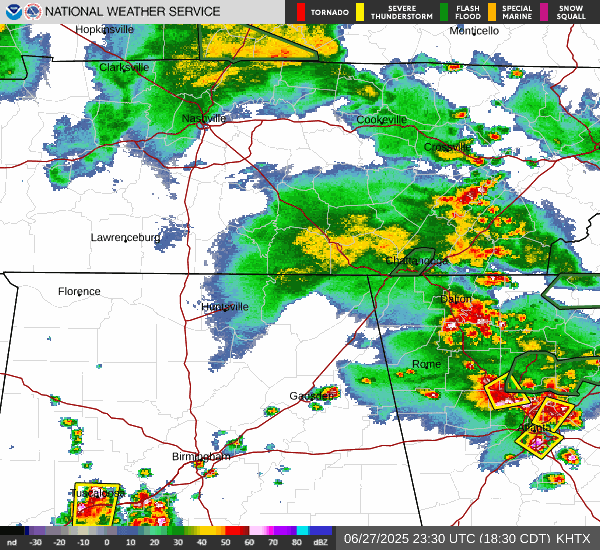
Even though storms have been isolated lately, they did bring a tree down along Lynnbrook Drive near Waterloo yesterday.

Then today in Jackson County, we had a thunderstorm that produced quarter-sized hail in Pigsah. A tree also came down on County Road 174 in the Flat Rock Community.
And you do get isolated strong summer storms that can do at least borderline-severe stuff like that. Nobody was injured. It's nowhere near as bad as our main severe weather season, but we all know that summer storms can pulse up and get pretty rowdy before they rain themselves out. And it's nothing to be overly alarmed about; you just have to be careful if you draw the short straw and get one of them. You're much more likely to get some beneficial rain out of a thunderstorm than any tree damage this time of year. And frankly, I don't mind some hailstones on a hot summer day. It's as welcome as the sound of an ice cream truck.


Our period of any excessive heat and humidity is over for a while, as we no longer have that "heat dome", the closed upper-level High pressure system bringing us an unusual level of heat for the time of year. It's still going to be hot and humid right now; we are nearly into July. But sensible summer precautions should suffice, much like what I was saying about the thunderstorms, even if a few get on the strong side once in a while and produce some hail or damage a few trees in isolated spots. A lot of this stuff is just the facts of life in the summer around here.
We do have surface High pressure in place over the Mid-South and Southeast right now and are under some longwave upper-level ridging that stretches through the Midwest, the Ohio Valley, up into New England. The closed High is down over the Florida Panhandle and Bend now. And we have the usual Gulf moisture that produces chances for rain each day.
You know, earlier today, there were even a few storms that prompted Flash Flood Warnings. But these summer storms that pulse up, even if the main threat is just heavy rain, tend to rain themselves out quickly. And like I say, nobody got hurt from the storms today. I really try to take a low-stress approach during the summer months. Unless something looks organized and truly threatening, I usually just give it a passing mention. Because I think everybody deserves a break after the core of the severe weather season, which ends in May. If you advertise drama all year round, nobody is going to care when it really is worth making some noise about. Like that event we had on March 15th this year, that was fairly serious business. And we had some other stuff in May, especially in Tennessee, but also in Madison and North Huntsville. And people need to know to take those days seriously. They can't know that if their circuits are already fried, like every time they turn around, the weather guys are saying "danger". Like sure, even lightning is dangerous. And if you hear thunder, you should probably go inside. Why risk getting struck by lightning? But I'm not going to run that point in the ground any more than I'm going to constantly remind people not to leave somebody in a hot car. At some point, people have to take responsibility for their own safety. And the only people who need those reminders when we've got typical summer weather are people who have not lived around here very long. They'll adapt.

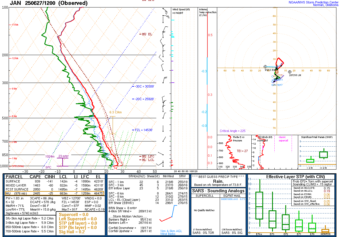

The 7 PM (00Z) sounding data is not in yet, so I'm using the 12Z (7 AM CDT) observations for the upper-air. And basically we were muggy without any wind shear to speak of. Typical summer stuff at Birmingham and also at Jackson (MS) and Nashville.
You might have noticed on the radar above, it does look like those storms developed in the Savannah Valley in Georgia and have moved "backwards" (East to West) to affect us. We also had an outflow boundary from Middle Tennessee to Northeast Mississippi that was the focus for a lot of the rain and storms earlier today. The storms in Georgia were associated with what's left of a weak upper-level trough. These are mesoscale features that are difficult to predict from day to day, even with better mesoscale and convection-allowing models now. Though we do get clues. Summer weather throws so many curves that a lot of people just throw up their hands and call it random.
So today our High was 88, and the Low was 73 in Cullman. I'm going to use that as more of a guideline than the model guidance. Between MOS and NBM products, I'd be tempted to put the Low in the 65-69 range and the High at about 88 again. Well, the High may be right. But I think the Low should be about 68-70 tomorrow. We're going to stay in this pretty typical pattern of widely scattered showers and thunderstorms, about a 30% chance, but more of us getting a mix of sun and clouds, and seasonable heat and humidity. The model guidance wants to put the chance of rain at 40%, but I think that's too high. I'm using my own judgement and undercutting it, going with 30%.
All the model guidance bumps the rain chances up some on Sunday, and I'll "give" a little by increasing it to 40%. Look for a High of about 87-88, Low of about 69-70.
Will maintain that 40% chance of rain for Monday with a High in about the 86-89 range, Low about 69-72 range. I really don't like to rely too heavily on model guidance in a typical summer pattern with high pressure and some ridging at a standoff with Gulf moisture producing random showers/storms and all these small-scale (mesoscale) boundaries that change so quickly from day to day. Usually climatology and common sense beats the models, and the numerical models just give us clues as to the trends for any variations in this typical summer pattern.


But the extended period is worth paying more attention to, as we have a cold front that's going to stall out in our region and dissipate, increase our rain chances some next week while doing so.
Tuesday looks like the wettest day with about a 50/50 shot at getting some rain, High in the mid-80's because of cloud cover and periods of rain possible. The Low should be 70 or so, about 70-73 range.
Wednesday it looks reasonable to bring the chance of rain back down to 40% with a High in the mid-to-upper-80's, Low near 70.
Then only a 30% chance of rain for Thursday, High in the upper 80's, Low in the upper 60's. As the front washes out, moisture levels will come down, less coverage of rain, is the trend here.
Then for Friday, which is July the 4th, Independence Day, looks like more sun than clouds, a High approaching 90 again, Low in the upper 60's or near 70. Chance of rain only 20%, so really isolated showers and thunderstorms possible. Most people's fireworks should be safe, based on what we can see seven days out.

Something interesting has popped up in the tropics. A broad area of low pressure over the Southwest Yucatan Peninsula is producing a large area of disorganized showers and thunderstorms. After it moves over the Bay of Campeche, some development is possible this weekend if a lot of it stays over the waters. A Hurricane Hunter may go in to investigate the system tomorrow (Saturday), but it's a dicey situation. By Monday it is expected to move into Eastern Mexico, and after that, it will fall apart over their mountainous land. Locally heavy rains will be possible over places like Belize and Guatemala as this moves through Eastern/Southeastern Mexico. Regardless of whether it forms any kind of short-fused tropical cyclone or not.

Then we've got another broad area of low pressure also producing showers and thunderstorms a few hundred miles South of the Gulf of Tehuantepec. These disorganized showers and storms will continue to move West/Northwest this weekend and into early next week, and a tropical depression is expected to form within the next couple days or so, as conditions become more conducive for these rain bands and storms to get more organized.
None of that poses a threat to the Gulf Coast, like up anywhere near Alabama.
Our weather is pretty calm right now.


No comments:
Post a Comment