(Forecast)
Friday (High 60, Low 50): Partly cloudy, breezy at times, cooler. Widely scattered lingering showers are possible.
Saturday (High 67, Low 53): Partly cloudy. Isolated showers are possible.
Sunday (High 72, Low 56): Partly to mostly sunny. Warmer.
(Extended Outlook)
Monday (High 70, Low 60): Showers and thunderstorms likely.
Tuesday (High 69, Low 48): Sunny.
Wednesday (High 71, Low 45): Partly cloudy.
Thursday (High 72, Low 59): Thunderstorms likely.
(Notes)
Congratulations to Ms. Elizabeth Leitman, who on Wednesday of last week, became the first woman to issue a severe weather watch at the Storm Prediction Center. I have seen her name on a lot of outlook discussions prior to that.
There is an upcoming SKYWARN class at Trinity Town Hall in Morgan County, 6 PM Wednesday March 8th. There are also online classes available in case you are not able to make it to one of the physical classes. These are free, by the way, and anyone with an interest in weather/public safety is strongly encouraged to try one out.
It is Severe Weather Awareness Week in Tennessee, and they are having a big event this Saturday on the campus of Trevecca Nazarene University.
Even if you're not up in Tennessee, it is a good time of year to review your safety plans for severe thunderstorms and tornadoes.
(Discussion)
At 4 PM it is mostly sunny in Cullman with a temperature of 81, and it looks like that is going to be our High for today. Which would be the same as yesterday. Our Low this morning was 68. I know some records were broken yesterday for High temps. I guess in a few days, someone will compile a list of that. I believe yesterday broke the record for both Huntsville and Muscle Shoals. So here in Cullman we have a dewpoint-temperature of 66, making the relative humidity 62%. Winds are from the Southwest at 8 miles per hour, with some higher gusts up to 18 mph. Barometric pressure is 30.07 inches and rising.
The observations are back from Jasper, where their station was down recently, looks like their current temperature of 82 will be their High for today. Their Low was 70 this morning. It is mostly sunny there as well, not as much of a breeze. Over in Gadsden, they are only up to 76 degrees under sunny skies and light South winds. They have a storm spotter class at the high school at 6 PM. It may have started by the time I finish writing and tweaking this. Fort Payne is partly cloudy and breezy, Southwest winds at 12 mph. They are only up to 77 degrees. Haleyville is at 81, looks like their High was 82 earlier this afternoon. It is mostly sunny there, South winds at 9 mph. Muscle Shoals saw a High of 85 today, Low of 72. I wouldn't be surprised if that broke another record.
Over in Tupelo they are at 86 degrees. Birmingham is at 80. Nashville is mostly cloudy and 82 degrees. Atlanta is mostly cloudy and 76. Memphis saw a High of 77 today and are now down to 68 with quite a breeze from the Northwest, gusts up to 23 mph. It is partly cloudy in Huntsville and 82 degrees, winds from the South at 10. Their Low this morning was 70. Fayetteville saw a High of 82. And so did Winchester. Winchester saw a Low of 70 this morning, Fayetteville saw 68.
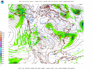
That cold front that brought our unsettled weather pattern this week is finally starting to push through the region, is why they are so breezy and cooler in Memphis right now.
That front actually stretches all the way back through the Rocky Mountains, and they've got a serious snowstorm still going on out West, also up into New England. New York even has some ice in the mix.
As that front continues to push through the region tomorrow, we will have a pretty decent northerly breeze most of the day, and much cooler temperatures, topping out at about 60 degrees with a Low near 50. And there will be enough wrap-around moisture to support some lingering showers, but I think they will be widely scattered in nature, about a 1-in-3 shot of any one spot getting one. Should be a mix of sun and clouds.
On Saturday, the strong high pressure ridge in the Gulf will cause our upper-level winds to become more zonal from the West. A weak disturbance will pass to our North in Tennessee, but around here I think any rain showers will be isolated. Should see a High near 67, Low of about 53.
Sunday this ridge of high pressure should be strong enough to keep us dry despite the front lifting back northward through the region as a warm front. Looks like a High in the lower 70's and Low in the mid-50's, might see a few less clouds.
Sunday does look like a severe weather day for the Great Plains, looking like it will start out as some supercells capable of producing tornadoes and large hail. And then quickly merge into a squall line where damaging winds are more the primary threat, but some large hail or isolated tornadoes are still possible. It is dicey whether this risk will end up extending as far North as Kansas City, and the Storm Prediction Center will continue to monitor that closely. Looks like this activity will get going during the peak heating hours of the afternoon, so if you know anybody out in Oklahoma especially, this could end up being a severe weather outbreak for them, might want to give them the heads up.
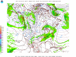
Then on Thursday, a stronger storm system swings in here, another cold front. And this one does look like a synoptic setup where we will have to watch for the potential of organized severe weather. As of right now though, the GFS is not showing any parameters that are even remotely concerning for that. And it may be another case where the high pressure over Florida and down into the Gulf of Mexico is keeping us out of trouble. It is too early to make that call really. I would watch this one a lot more closely than the system on Monday, but it's to the time of year, you really have to keep an eye on all of them, just to be on the safe side. Looks like a High in the lower 70's and a Low rebounding quickly into the upper 50's. This is seven days out, and my advice is to keep an eye on it. Right now it looks like general thunderstorms, but with the synoptic setup and the time of year, definitely have to watch how the conditions trend. Sometimes the models do not handle well what the atmosphere will be like this far in advance, when we've got two storm systems. Right now we've got a front coming through tonight and tomorrow, then another one on Monday. So even for the best computers in the world, this is a lot to calculate, what the atmosphere will be like going into Thursday. Considering our pattern lately, this may be general rain and thunderstorms. But if you want to play it safe, keep an eye on this system in case model trends do start to make it look concerning. It can happen this time of year. As we get toward April is when the chances for severe really ramp up most years, but every year is different. And we've seen some stormy days even in the Winter months, more than usual this year.
Rainfall totals should average between about a half-inch and an inch for most of us, the higher amounts mainly up across the Tennessee state line. The rain this weekend looks widely scattered. The stuff on Monday and Thursday looks like it could be more widespread and organized.
Just for fun, here's a look at some of the record highs for today.
P.S. Adding this note at 6:03 PM - saw from the National Weather Service in Huntsville that today's High of 86 in Muscle Shoals is the highest temperature ever recorded there for the month of February. And as the map above may show, the previous record was set in 2012 when it was 83 degrees.


No comments:
Post a Comment