President's Day (High 67, Low 48): Breezy with clouds gradually increasing throughout the day. Scattered rain showers are possible at night.
Tuesday (High 70, Low 59): Cloudy and breezy. Periods of scattered rain showers are possible throughout the day and night.
Wednesday (High 80, Low 62): Mostly cloudy, muggy, and windy. Periods of widely scattered showers and thunderstorms are possible, mainly in the afternoon and evening - and some could become strong, or even reach severe limits.
Thursday (High 82, Low 63): Becoming partly to mostly sunny with a 20% chance of a lingering shower.
Friday (High 61, Low 52): Partly to mostly sunny.
Saturday (High 76, Low 54): Increasing clouds with a 30% chance of showers/thunderstorms.
Sunday (High 72, Low 60): Mostly cloudy with a 50% chance of showers/thunderstorms.
SKYWARN classes are being held by the Huntsville and Birmingham offices ahead of our Spring severe weather season, with some actual in-person classes again as well as the online ones. They are free, and anyone with an interest in learning more about storms/weather is welcomed to take one.
There were a few tornadoes confirmed across the Tennessee border from our last severe weather event on February 16, also some damaging straight-line thunderstorm winds in Wayne County estimated at 70 mph.
And that Nashville office is very busy right now, with some classes on the basics of weather safety, and also Severe Weather Awareness Week this week, culminating in a Severe Weather Awareness Day with several good speakers lined up this coming Saturday.


As we approach 4:30 PM in Cullman the skies remain sunny, with a temperature of 63 degrees, looks like that is going to be our High for the day. The Low this morning was a little "warmer" than expected, at 41 degrees. We did have a few clouds overnight that limited the radiational cooling we needed to drop down into the 30's. Back to the present, while it is 63 degrees, our dewpoint temperature is 21 degrees, making the relative humidity 25%. Winds are from the Southwest at 14 miles per hour. Most of today has been breezy with Southwest winds. Barometric pressure is 30.12 inches and holding steady. Looking to some of our neighbors, the observations for Jasper are not available here lately. Haleyville is sunny and 63 degrees, had a Low of 39 this morning. And up in Fort Payne, it is sunny/breezy and 61 degrees. They made it up to 62 within the past hour. Their Low this morning was 33 degrees at that higher elevation.


The models were right about the shift in the upper-level pattern to bring us wind flow more from the West/Southwest, bringing up some Gulf moisture into the region again. Also notice we have a cold front across the Midwest and a Low pressure system around Kansas City.
But let's also look at a weather map that's less technical and easier to read for the average person. We have high pressure still centered over the Southeast and Mid-Atlantic that is keeping our weather dry for now. You can see our most recent cold front (that caused those storms on the 16th, think that was Thursday) stalled out from about Miami to the coast of Southern Mexico. Then we have that front across the Northern Plains/Midwest. Got a little snow/ice going on along the Rocky Mountains, some rain South of there in New Mexico and parts of Arizona. Minnesota and the Dakotas, mainly North Dakota for now, are dealing with some more significant snow.
And while I was looking at that, I noticed that a significant winter storm is expected to affect the Pacific Northwest and much of the country the next few days. So I just made a link to what the Weather Prediction Center is saying about it. For the hardest hit areas, it does look like a big deal, with a few feet of snow possible. No such luck (?) around here.
Tomorrow that front will make some progress while high pressure stays centered in the Gulf of Mexico, so slowly shifting to our South. It looks like the front will try to stall out this week before finally passing through our region late in the week. Again, that winter storm up North does look like it means business. I think tomorrow will be a day of increasing clouds and breezy again like today, with any rain holding off until the night hours. High of about 67, Low rebounding to about 48.
By Tuesday we definitely get into a stalled-front messy unsettled situation. Looks like a High near 70, Low approaching 60, probably 58-59. We'll have a good breeze on these days even outside of any showers or storms. Going with a 40% rain chance on Tuesday.
And I started to show the raw model data today, but I think I'll go with the simple weather maps instead. The models do not handle unsettled patterns like this in a way that is easy to show and explain. There are differences in timing and placement of certain things. Here from the WPC graphics of fronts and sea level pressure, you can get the main ideas.
Even on Wednesday, it looks like the best chances of any severe thunderstorms stay to our West, mainly around Memphis back through much of Arkansas, Northern Mississippi, and Northern Louisiana. The risk area does clip East Texas as well.
And now that the severe weather parameters are within reach of the NAM, I can tell you, nothing looks concerning there. I guess if you live in Northwest Alabama or adjacent parts of Tennessee, this risk is worth keeping an eye on, but for now it continues to look like most of us may luck out, despite how warm it will be for this time of year. Things just look out of phase for organized severe weather.
It does bear monitoring though. The SREF brings enough instability and wind shear up through Mississippi on Wednesday afternoon and evening, all the way up to clipping the Shoals, to support at least a marginal threat for severe weather, including the threat of some rotating storms. So this may be a close call where we do need to continue to keep an eye on it. These temperatures are awfully warm for late February.
The High on Wednesday looks to make it to about 80 degrees, with a Low in the lower 60's. And it's going to be a day with gusty winds, even outside of any showers or storms that form and can sustain themselves. The lack of a strong lifting mechanism combining with the wind energy and however much unstable air we get may keep us from having an organized severe weather threat around here, but this is a situation where any change in the small details could make a significant difference.
For now it looks like any organized severe storms will stay to our West, but folks around the Shoals might want to watch it just in case, and actually along the Western border of the state in general, if you're someone who likes to play it safe, keep an eye on how this trends.

Thursday it looks like the rain will be tapering off. A lot of the rain and any storms may come Wednesday night into Thursday morning. And it doesn't look like a continuous soaking rain, more like periods of showers/storms, generally more clouds than sun and staying breezy from Tuesday through at least early Thursday. Looks like we will be clearing and becoming partly to mostly sunny on Thursday with a High in the lower 80's (as crazy as that is to say for this time of the year, it isn't even March) and a Low in the lower 60's. Actually it is probably better to keep a 20% chance of showers in there because we could have a lingering shower or two as the front passes during the day and night. Still may see more sun than clouds overall.

Then on Friday with the passage of the front, we'll see Highs dropping back to 60 or so, Low back to 50-ish. Skies should be partly to mostly sunny. Guess can't rule out an isolated shower, but overall I think the rain is over at least for the one day. This is a really dynamic pattern though.
While things do stay moving in this pattern, it looks like this front is going to pester us for a while. It is expected to move back northward on Saturday as a warm front, increasing temperatures and putting rain chances back in the forecast. Looks like mid/upper 70's for the High on Saturday, Low in the lower 50's. Rain chance should stay on the low end of about 20-30%.
And then on Sunday, enough rain to cool the High down to the lower 70's again, but enough moisture to bring the Low up to about 60.
It's questionable whether we even get enough instability on Saturday and Sunday for thunderstorms. But these temperatures are definitely very warm for this time of year. It is an unusual pattern we're dealing with this week.
One thing that I saw a forecaster point out, maybe from the Huntsville NWS office, is that if the severe weather threat does get organized on Wednesday, the most likely storm mode will be supercells, which will probably stay back over Mississippi. But that forecaster was echoing my thoughts, that people in Northwest Alabama and up into Southern Middle Tennessee will want to monitor any activity, since it's not that far from the Mississippi line. And if any storms do get severe and sustain a long time, of course it would be wise to keep an eye on them. We'll see how that threat develops to our West over the next couple days and how it might impact some of our western counties. It is a close call, just something to keep an eye on. If you live somewhere like Muscle Shoals, Hamilton, Waynesboro, I would definitely keep an eye on this, not because it looks like a big outbreak as of right now, but just to be on the safe side. As we saw again last week, all it takes is a few storms going severe to cause some problems. There was an injury with a tornado that was rated E/F-2 from that event in Mississippi, think it was the one close to the town of Ripley. And I saw where a mobile home was destroyed by a tornado that day, think it was a different ("weaker") tornado. And even those straight-line winds of 70 mph in Wayne County (TN) could have caused injury or death to someone caught without proper shelter. So it does not take a big outbreak of storms to make it worth watching and taking somewhat seriously.

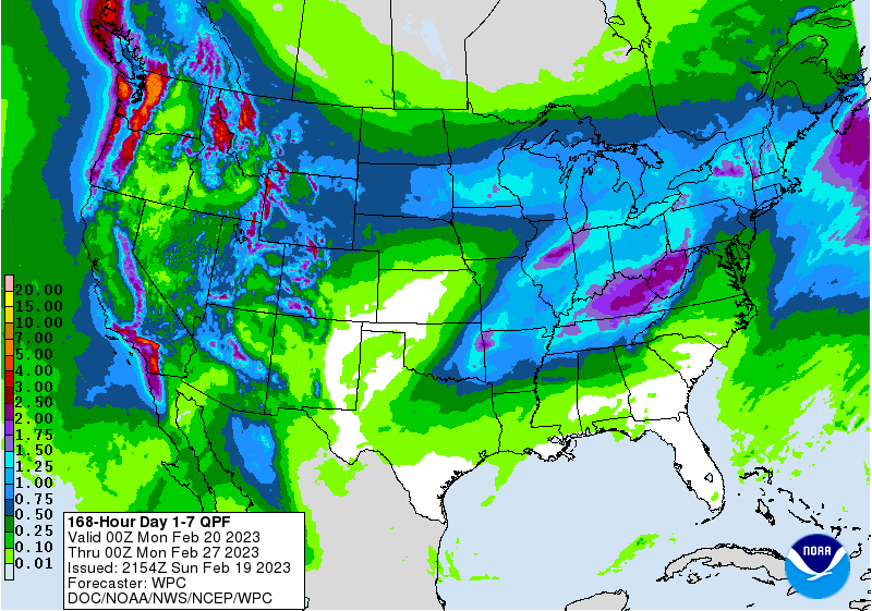
Tennessee counties probably get about an inch of rain over the next seven days, and Alabama counties, probably closer to a half-inch on average. So even with all these rain chances, it is an unsettled pattern where it does not look like an all-day rain. Even if we did get some of the severe storms, I think they would tend to be scattered around, might even be better to say "isolated". And we may not have any serious problems around here at all. But it is going to be warm, breezy, and unsettled, kind of a strange pattern for late February.


No comments:
Post a Comment