(Forecast)
Monday (High 66, Low 43): Mostly sunny. Cool and breezy.
Tuesday (High 70, Low 40): Sunny. Mild temperatures and low humidity.
Wednesday (High 75, Low 42): Mostly sunny. Mild temperatures.
(Extended Outlook)
Thursday (High 74, Low 49): Partly cloudy with a 20% chance of showers.
Friday (High 73, Low 56): Partly cloudy with a 30% chance of showers and thunderstorms.
Saturday (High 79, Low 55): Partly sunny.
Sunday (High 72, Low 59): Rain and thunderstorms likely.
(Notes)
Here is a look at the F-3 tornado damage that happened along the Alabama/Tennessee line on April Fools Day, that overnight event, around Hazel Green to Huntland, that tornado. And here is a look at things more on the Tennessee side, including the Waynesboro tornado. Also had tornadoes at Hackleburg and Sardis City, and this link from the Birmingham office has the most links to where to find other information from other offices across the country, so might be your best one-shop stop. Prior to that, Central Alabama also had several tornadoes and severe thunderstorms from March 24-27.
Yesterday was the anniversary, last night, of the Oak Grove tornado of 1998, which was given the rare F-5 rating, killed 32 people, injured more than 250.
The National Weather Service in Nashville is continuing Weather101 starting tomorrow. Monday's class is on wind.
And then since we do have a lull in the action for severe weather this season (which runs through the end of May, tornado season), it might be a good time to make a severe weather safety plan, if you have not already. Just in case we have more problems before summer gets here.
(Discussion)
It is so lovely out today that I started to post a picture instead of a satellite image. But I had a long night; someone I know had to go to the hospital for what seemed like a stroke but turned out to be something less serious. So I guess I'm being lazy by only looking out the window and not sharing a picture of the lovely sky with the rest of you. Or maybe you're the ones being lazy, if you don't go out and soak up the sun. Somebody sent me pictures of some Easter cakes she and her kids made today. I guess that takes it a step beyond coloring and hiding eggs.
But seriously, we have a drastic change in the weather pattern today in the Tennessee Valley. At 3 PM we have a little more clouds than sun in Cullman, fair-weather cumulus clouds (though you can see on the visible satellite, some other places have cirrocumulus as well), but still a lot more sunshine than we've seen in a while. It is 63 degrees, and the dewpoint is 50 degrees, making the relative humidity 64%. Winds are from the Northeast at 9 miles per hour. The pressure is 30.29 inches and falling slowly. The Low this morning was 48. At times the winds have gusted up a little higher, been breezy behind this front.
Jasper has some haze and actually a lingering light rain shower and is at 68 degrees. Visibility is down to 3 miles there for now. It is overcast and 65 in Haleyville. Fort Payne is partly cloudy and 63.
Muscle Shoals is overcast and 65. Same for Decatur. Huntsville is mostly cloudy and 66. Gadsden is sunny and 67. Birmingham is mostly cloudy and 68. Nashville is at 69 degrees, with Northeast winds gusting up to 23 mph there. Memphis is partly cloudy and 65. And Tupelo is overcast with calm winds and 68 degrees.
Overall a nice day across the region even if it varies from place to place. We are finally on the retreating edge of this cold front. If you'll notice on the upper-air 500 millibar map, the upper-level wind flow is "split", like it comes from the Pacific Northwest, but as it moves through the Rocky Mountains and into the Midwest and Southeast, it splits up into a more southerly and more northerly flow.
That pattern will continue tomorrow, and we'll be under the influence of high pressure centered over the Mid-Atlantic and New England. We will have sunny skies, really good radiational cooling conditions tonight, so a Low near 42 tomorrow, a High tomorrow afternoon near 66. Mainly decided to post an updated forecast because I noticed the cooler trend in nighttime/early morning temperatures.
The surface High parks right over our region on Tuesday. The High will warm back up to about 70 with abundant sunshine, but the morning Low will stay down close to 40 or so, with again, very dry air (low humidity) and great radiational cooling conditions.
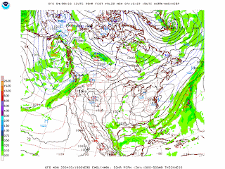
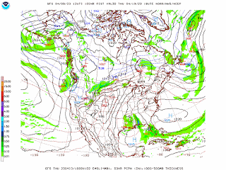
Then on Wednesday the GFS is still showing the development of a Gulf Low. The ECMWF actually shows this too, just later on Wednesday into Thursday, slightly slower timing, which is typical.
One point that I just saw skimming over a forecast discussion from NWS Birmingham is that tonight into tomorrow will stay breezy enough that the radiational cooling is not as much as it would be otherwise. Forgot to take that into account earlier. Will keep in mind when forecasting for tonight/tomorrow.
Anyway we should not even see a significant increase in clouds around here on Wednesday, mostly sunny skies staying in place, and the High should be mid-70's, Low in lower 40's still.
The GFS does show some rain chances creeping up in here on Thursday.
Again, the ECMWF is a little slower with it, but shows same basic idea. Rain chances should stay minimal, but Low still rebound to near 50 degrees, High in mid-70's again.
Looks more like scattered showers on Friday, at least a 30% probability, maybe more like 40%, since the ECMWF has come into pretty good agreement with the GFS for this time period. But my instinct based on experience and looking at this pattern makes me want to trim the rain chances back just a tad below what models are showing. Day temperatures about the same, but Low should come up into mid-to-upper-50's.
Then on Saturday we are in between systems. Got another system moving quickly behind this one, a cold front moving through Midwest/Mid-South on Saturday. Around here we should have partly cloudy skies, probably little to no rain, High getting back up near 80, Low staying in mid/upper 50's.
Then on Sunday of next week, that front moves through our region. The GFS shows it in a weakening phase.
The European model shows it being a little more robust. And I think it has a better handle on things. Including at least a 50% chance of rain for next Sunday, may go ahead and put it in the likely category. High should come down to the lower 70's, Low getting up near 60.
As far as any severe weather, you have to watch every system this time of year. Going to be tricky outlining rain chances for Thursday into Friday and then for next Sunday - may just go "likely" for Sunday. The setup looks more favorable for stronger storms on Sunday than the Thursday/Friday time period.
The Storm Prediction Center mentions they may have to outline a risk area somewhere in the Southeast for Thursday in later outlooks. But the GFS is not showing a concerning combination of instability and wind shear in the Tennessee Valley for either Thursday/Friday or for next Sunday, at this point.
Rainfall totals for most of us will probably be under a half-inch for this forecast period.


No comments:
Post a Comment