These severe thunderstorms have formed into lines and clusters and will bear monitoring as they move into and through Alabama counties. Planning on posting updates here approximately every hour or as needed if I notice anything getting really out of hand locally, may even start a new post depending on situation.
7 PM - And we already have severe thunderstorms affecting Waynesboro and Waterloo, sort of forming a broken line. Another cluster of severe storms affecting Booneville and Tishomingo back in Mississippi. These storms are capable of 60 mile per hour wind gusts and hail anywhere from quarter to ping-pong-ball size. So you want to stay inside away from windows or anything electrical while these pass through. And if you can, be in a sturdy house (rather than a mobile home) on one of the lower floors, not up on the top floor, especially if there are trees around. Also don't get caught driving through any of these storms. At least pull over and park, but it's better if you can get into a substantial structure, even if that's just a little restaurant or gas station, if one of these storms were to approach while you're out driving. If I was out eating somewhere or at a church service, I'd stay put until the storms pass. A strong public building will protect you in a way that your car might not.
7:14 - All right, that storm moving Southeast from Waynesboro has prompted a Tornado Warning for Wayne and Lawrence counties in Tennessee until 7:30. So if in the path of that, to be on the safe side, you need to be in a sturdy house (rather than a mobile home), in a small room or hallway near the center of the house, away from windows, on the lowest floor. There is enough rotation showing up in this storm that it could be producing a tornado.
Tornadoes are rare this time of year around here, but sometimes it is a close call, looking at radar data, whether the winds are blowing in a straight line or are rotating enough that there may be a tornado there. And the National Weather Service in Nashville thinks this storm is capable of producing a tornado.
7:22 - Note from NWS Nashville, this storm has weakened below severe limits, no longer showing any signs of producing a tornado, but may still produce gusty winds and heavy rainfall, a strong thunderstorm, but under severe limits. So they are going to let this tornado warning expire on time.
7:24 - And it looks like Huntsville is letting go of that warning for Waterloo too in Lauderdale County. For now it looks like the storms along this squall line around here are strong thunderstorms but under severe limits.
7:29 - The concern for now seems to be for strong winds and small hail, under severe limits. But several storms back in Mississippi are showing signs of being severe. So it is a matter of how well those sustain as they move into Alabama. The air got pretty unstable today, and until some rain comes in to cool things off, a lot of that instability could last into the night hours.
7:32 - Emergency management reports that earlier this afternoon in Crossville, TN about 4:58 PM, a house was significantly damaged by severe thunderstorm winds, could have been a tornado, but tornado-like damage anyway. So in light of that, I'd take a Severe Thunderstorm Warning seriously tonight if you get one.
Best thing to do is shelter in a small central room (or hallway) on the lowest floor of a sturdy house, away from windows. Better if you are out of a mobile home and in a house that is anchored down to the ground, ahead of these storms.
7:35 - That storm coming out of Tishomingo has prompted a severe thunderstorm warning for Colbert and Franklin counties over on the Alabama side. Communities like Malone, Mynot, Cedar Creek Reservoir, Srygley Church, Allsboro, and Maud could be affected by winds up to 60 miles per hour and quarter-sized hail.
7:38 - And now for Lawrence and Giles Counties in Tennessee, we have a severe thunderstorm warning. This storm is again showing some weak rotation, but the main threat is damaging winds, could also have large hail and a lot of lightning. Communities like Lawrenceburg, Pulaski, Ardmore, Elkton, and Minor Hill, or places near there, within that warning polygon, need to stay in a good safe place until this part of the line of storms passes or the warning is cancelled.
7:44 - Bottom line, we've got a squall line forming now and moving into North Alabama from Southern Middle Tennessee. And some storms within it may still reach severe limits even though we are getting into the dark hours. Main areas of concern right now are in Colbert and Franklin Counties in Northwest Alabama and also in Lawrence and Giles Counties in Southern Middle Tennessee. Either of those places could be getting hit with damaging winds and large hail from these storms. Other places along the line, storms currently do look on the strong side, but under severe limits.
7:46 - There are still a lot of storms showing signs of being severe back in Mississippi. Remains to be seen whether they will weaken by the time they cross the Alabama line. I think some of them will hang together and still pose some threat of severe winds or hail.
We’ve had at least TWO tornado touchdowns this afternoon on the plateau. The first video clip was taken in downtown Crossville around 5 p.m. CDT. The second video is from the Grimsley area of Fentress County during the 4 o’clock hour. If you had any damage or photos/videos of… pic.twitter.com/smZjq6tOXh
— Upper Cumberland Weather (@CumberlandWx) June 11, 2023
7:53 - Wow, that storm near Crossville earlier did indeed produce a tornado. While the tornado threat is low with this system, this time of year, to be on the safe side, I would go ahead and take similar precautions to for a tornado - small central room on the lowest floor of a sturdy house - would not shelter in a mobile home if you can possibly get to a safer place ahead of the severe storm.
7:57 - And here are our two main areas of concern now, new warnings just issued. Places like Fayetteville, also down at Belgreen, Russellville, Phil Campbell . . . I'd be in a good safe place until these storms pass.
7:59 - Taking the wide view, you can see these storms still forming a broken squall line. That storm headed for Russellville and Phil Campbell is still sort of out to itself, so more fuel for it. Areas downstream on the Alabama side want to monitor these storms and prepare accordingly. You have to respect the history of these storms today, how they have done some damage, including structural damage.
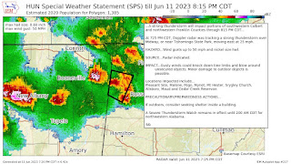
8:19 PM - That storm in Lincoln County may have winds of 60-70 mph and be capable of considerable damage, Weather Service in Huntsville issued a new warning on it.
Damage to trees and some power outages are likely in the path of particularly that storm within the line. So you need to be sheltered in a sturdy house or other building as best you can, preferably on the lowest floor, near the center of the house, away from windows. And sometimes getting into a smaller space can help if you have trees around that could fall, it is harder for them to fall into a smaller room like a hallway or bathroom where the walls are built closer together.
8:23 - And here is the wide view again.
8:31 - That severe thunderstorm warning that included Russellville in NW AL has been allowed to expire at 8:30. The other warning that includes Fayetteville in S-Mid-TN goes until 8:45. Its wind damage threat is thought to be considerable, winds up to 70 mph.
By the way, any of these storms along the line can be some strong storms, and may spook somebody in your house, even if that's just one of your pets. But the warnings are issued for storms thought to pose a threat to life or property, by having winds at least 50 knots/58 mph or hail at least quarter-sized/inch in diameter.
There are Special Weather Statements being issued for thunderstorms that are under severe limits, but I'm saving my energy for the ones that might be a threat to life or property and actually prompt warnings. Strong storms are moving into Huntsville right now, but as of right now, they are thought to be under severe limits.
Actually I misspoke, those storms are moving into Harvest in Madison County, will not be to Huntsville for a little while.
8:37 - And here is our newest Severe Thunderstorm Warning.
8:47 - And now back down in West Central Alabama, Marion and Northern Lamar Counties have been put under a Severe Thunderstorm Warning for a storm coming out of Mississippi. Damaging winds up to 60 mph and quarter-sized hail are the main threats. But some rotation has shown up in the storm too. And a Tornado Warning was issued for it back across the MS state line.
8:54 - Phil Campbell now included in a Severe Thunderstorm Warning.
8:56 - And now Winston County joins the club, mainly the Northern half, but the storms are moving Southeast.
9:02 PM - The warning along the TN/AL state line has been let go on time. The areas of concern now are places like from Phil Campbell to Double Springs, Haleyville, Hamilton, back to Sulligent and Vernon. Damaging winds are still possible in those severe thunderstorm warned areas. And best thing to do is shelter inside a sturdy house, lowest floor, interior hallway or other room away from windows.
By the way, Bankhead National Forest is included in the Severe Thunderstorm Warning.
9:08 - Enjoying Chelsea Aaron's whimsical comments back to her haters who wish Brad was working instead . . .
9:12 - Haleyville, Arley, Double Springs, Helicon, Smith Lake are still in the path of this part of the squall line producing potentially severe winds up to 60 mph and hail up to quarter-size.
Hytop radar has gone down, and there are power outages reported by broadcast media in North Huntsville, more than one source. I am not sure if that is from strong winds or lightning, I would suspect lightning, as there are no warnings up that way for wind.
The lightning sure is fierce with a lot of these storms, and I could see it knocking some power out.
As these storms move into Cullman County, the NWS Huntsville believes things are just under severe limits, with wind gusts up to 55 mph possible and some small hail about a quarter-inch in diameter. From Cullman to Good Hope down to Hanceville, Garden City, Colony, and even Dodge City and back to West Point, these are still some strong storms. And I'd advise you to stay inside away from any windows and just be in the safest place that you can. This is a borderline situation where a warning has not been issued, but some minor damage to something like trees or power lines could still occur, or to a weak structure, or maybe even a window in a house.
If you're on a top-floor apartment in Cullman or one of these other places, might see if one of your neighbors on the lower floor will let you come down and ride the storm out, especially if there are trees nearby. Which was the case with some apartments I live in when I lived in Huntsville up on the top floor, had a tree out the window with best view of storms back then.
9:23 - And here's a radar update since things are localized now. I believe I hear a neighbor out dancing around enjoying the lightning show . . .
By the way, I don't advise that. Just having a sense of humor since he's going to do it anyway.
9:26 - The storms in Winston and Cullman Counties are currently thought to be strong but under what we'd look for with severe criteria for wind, and the hail is not expected to be severe either.
But still watching potential for damaging winds/large hail with the storms in Marion, Lamar, and now Fayette Counties further back West. Severe thunderstorm warnings are in effect there.
9:37 - And now it is good to see the Hytop radar working again, think that outage was momentary. Most of these storms just have a lot of lightning, which does not make them severe. The lightning is still dangerous, and you want to stay inside away from anything electrical, also away from windows. And there may be some small hail and high wind gusts.
The only ones severe are in Lamar, Marion, and Fayette counties at this point, and back in Mississippi, communities like Amory, the name of that county escapes me at this hour.
In those warning polygons, I would take some degree of shelter, even if it's not as hardcore as you would for a tornado warning.
More power outage reported in Huntsville, as far South as Brownsboro actually.
9:40 - New special weather statement issued as these storms push further South into Cullman County. Again, the hail is pea-sized, nowhere close to severe, and the wind is estimated just a little shy of severe criteria. Still I advise using common sense when protecting yourself/loved ones from the weather tonight.
Even if you live as far South as Crane Hill, Brushy Pond, Bremen, I would be in a reasonably safe place as these storms come through, even though they are just under severe limits at this point.
9:45 - Same advice for folks in places like Dora, Sumiton, Blountsville, Curry . . .
9:51 - As the line of storms tracks on East/Southeast, the estimates of wind speeds continue to come down below severe criteria. Wind gusts of 30 miles per hour are kind of strong, but it would be ridiculous if a warning came out every time a storm produced those. The National Weather Service offices only issue a Severe Thunderstorm Warning when the winds or hail are thought to be damaging enough to pose a threat to life and/or property.
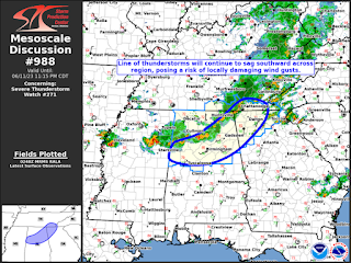
9:54 - Note from SPC about how this squall line has formed and most storms have stayed under severe limits, but a few have produced damaging wind gusts, and that could still happen over the next couple hours as it continues to move out of North Alabama.
Soon the line will be into Central Alabama. And the watch will be cleared for more counties as it moves along.
9:56 - As of right now, all the Tennessee counties have been cleared from the watch, bordering counties I mean, except for Lincoln, Moore, Franklin, and Marion. And as of right now, all Alabama counties remain under the watch, which expires at 2 AM. But I think all of North Alabama will be in the clear within the next hour or two.
9:58 - Passing along another note for our friends down in Walker County. These storms are looking to stay below severe limits, but understand it is still a rough storm with some gusty winds, so of course you want to stay inside away from electrical stuff or any windows. I know that I reiterate a lot of common sense stuff here, but . . . I heard one of my neighbors out dancing in the lightning. Sometimes I've taken goofy chances with storms. And it is easy for the average person to simply forget. Not trying to insult anyone's intelligence when I throw in these common-sense reminders.
10:02 PM - Saw report of some trees and power lines down in Lamar County from about 30 minutes ago.
All the severe thunderstorms are back across the Mississippi state line now though.
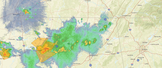
10:04 - Here's a better radar image above. Somehow I goofed earlier and gave the image from the Memphis radar. This one is from Hytop in Jackson County AL.
10:07 - Also seeing a report of some damage in Winfield, some power lines down and even some roof damage, also from around 9:30 or so.
10:24 - The severe thunderstorm watch remains in effect for North Alabama and some of the eastern counties of Southern Tennessee until 2 AM. I suspect it will be cancelled out around here by about Midnight, but I think they are watching for redevelopment of isolated storms behind the main line. After all, the dewpoint temperature at Muscle Shoals is still 70.
11:05 PM - For the most part, North Alabama has been cleared from the watch. And I am ending coverage for the night.
SEL1
URGENT - IMMEDIATE BROADCAST REQUESTED
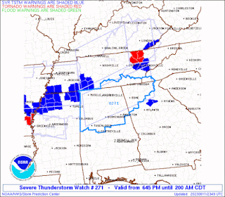
Severe Thunderstorm Watch Number 271
NWS Storm Prediction Center Norman OK
645 PM CDT Sun Jun 11 2023
The NWS Storm Prediction Center has issued a
* Severe Thunderstorm Watch for portions of
Northern Alabama
Northwest Georgia
Extreme western North Carolina
Southeast Tennessee
* Effective this Sunday night and Monday morning from 645 PM
until 200 AM CDT.
* Primary threats include...
Scattered damaging wind gusts to 70 mph likely
Scattered large hail events to 1.5 inches in diameter possible
SUMMARY...A line of strong to severe storms will push southeastward
across the watch area this evening. Strong winds aloft and
sufficient instability will pose a risk of damaging wind gusts and
some hail.
The severe thunderstorm watch area is approximately along and 55
statute miles north and south of a line from 55 miles south
southwest of Muscle Shoals AL to 85 miles east of Chattanooga TN.
For a complete depiction of the watch see the associated watch
outline update (WOUS64 KWNS WOU1).
PRECAUTIONARY/PREPAREDNESS ACTIONS...
REMEMBER...A Severe Thunderstorm Watch means conditions are
favorable for severe thunderstorms in and close to the watch area.
Persons in these areas should be on the lookout for threatening
weather conditions and listen for later statements and possible
warnings. Severe thunderstorms can and occasionally do produce
tornadoes.
&&
OTHER WATCH INFORMATION...CONTINUE...WW 265...WW 266...WW
267...WW 268...WW 269...WW 270...
AVIATION...A few severe thunderstorms with hail surface and aloft to
1.5 inches. Extreme turbulence and surface wind gusts to 60 knots. A
few cumulonimbi with maximum tops to 500. Mean storm motion vector
30030.
...Hart
WOUS64 KWNS 112344
WOU1
BULLETIN - IMMEDIATE BROADCAST REQUESTED
SEVERE THUNDERSTORM WATCH OUTLINE UPDATE FOR WS 271
NWS STORM PREDICTION CENTER NORMAN OK
645 PM CDT SUN JUN 11 2023
SEVERE THUNDERSTORM WATCH 271 IS IN EFFECT UNTIL 200 AM CDT
FOR THE FOLLOWING LOCATIONS
ALC007-009-015-019-027-029-033-043-049-055-057-059-071-073-075-
077-079-083-089-093-095-103-107-115-117-121-125-127-133-
120700-
/O.NEW.KWNS.SV.A.0271.230611T2345Z-230612T0700Z/
AL
. ALABAMA COUNTIES INCLUDED ARE
BIBB BLOUNT CALHOUN
CHEROKEE CLAY CLEBURNE
COLBERT CULLMAN DEKALB
ETOWAH FAYETTE FRANKLIN
JACKSON JEFFERSON LAMAR
LAUDERDALE LAWRENCE LIMESTONE
MADISON MARION MARSHALL
MORGAN PICKENS SHELBY
ST. CLAIR TALLADEGA TUSCALOOSA
WALKER WINSTON
GAC015-047-055-057-083-085-111-115-123-129-143-187-213-223-227-
233-281-291-295-311-313-120700-
/O.NEW.KWNS.SV.A.0271.230611T2345Z-230612T0700Z/
GA
. GEORGIA COUNTIES INCLUDED ARE
BARTOW CATOOSA CHATTOOGA
CHEROKEE DADE DAWSON
FANNIN FLOYD GILMER
GORDON HARALSON LUMPKIN
MURRAY PAULDING PICKENS
POLK TOWNS UNION
WALKER WHITE WHITFIELD
NCC039-043-120700-
/O.NEW.KWNS.SV.A.0271.230611T2345Z-230612T0700Z/
NC
. NORTH CAROLINA COUNTIES INCLUDED ARE
CHEROKEE CLAY
TNC011-051-065-103-115-127-139-153-120700-
/O.NEW.KWNS.SV.A.0271.230611T2345Z-230612T0700Z/
TN
. TENNESSEE COUNTIES INCLUDED ARE
BRADLEY FRANKLIN HAMILTON
LINCOLN MARION MOORE
POLK SEQUATCHIE
ATTN...WFO...BMX...MRX...HUN...FFC...


.png)


.png)

.png)
.png)


No comments:
Post a Comment