(Forecast)
Today (High 97): Sunny. Very hot and humid.
Sunday (High 91, Low 72): Partly to mostly sunny. An isolated shower or thunderstorm is possible.
Monday (High 87, Low 69): Partly cloudy with milder temperatures. Widely scattered showers and thunderstorms are possible.
Tuesday (High 85, Low 66): Partly to mostly sunny with mild temperatures. An isolated shower or thunderstorm is still possible.
(Extended Outlook)
Wednesday (High 84, Low 63): Mostly sunny.
Thursday (High 82, Low 60): Sunny.
Friday (High 83, Low 61): Sunny.
Saturday (High 85, Low 63): Mostly sunny.
(Pronóstico)
Hoy (Máxima 97): Soleado. Mucho calor y humedad.
Domingo (Máxima 91, Mínima 72): Parcialmente a mayormente soleado. Es posible que se produzcan una lluvia o tormenta aislada.
Lunes (Máxima 87, Mínima 69): Parcialmente nublado con temperaturas más suaves. Es posible que se produzcan lluvias y tormentas eléctricas ampliamente dispersas.
Martes (Máxima 85, Mínima 66): Parcialmente a mayormente soleado con temperaturas suaves. Aún es posible que se produzcan una lluvia o tormenta aislada.
(Perspectiva Extendida)
Miércoles (Máxima 84, Mínima 63): Mayormente soleado.
Jueves (Máxima 82, Mínima 60): Soleado.
Viernes (Máxima 83, Mínima 61): Soleado.
Sábado (Máxima 85, Mínima 63): Mayormente soleado.
(Beach Forecast)
Today (High 96, Low 82): Partly cloudy, hot and humid. Widely scattered showers and thunderstorms are possible.
Sunday (High 94, Low 83): Partly cloudy. Scattered showers and thunderstorms are possible.
Monday (High 92, Low 82): Partly cloudy. Numerous showers and thunderstorms are possible.
Tuesday (High 89, Low 78): Partly to mostly cloudy. Numerous showers and thunderstorms are possible.
Wednesday through Saturday (Highs near 90, Lows in upper 70's): Partly to mostly cloudy. Scattered to numerous showers and thunderstorms are possible.
Keep an eye on the track of Tropical Cyclone Gert.
(Pronóstico de la Playa)
Hoy (Máxima 96, Mínima 82): Parcialmente nublado, caluroso y húmedo. Es posible que se produzcan lluvias y tormentas eléctricas ampliamente dispersas.
Domingo (Máxima 94, Mínima 83): Parcialmente nublado. Es posible que se produzcan lluvias y tormentas dispersas.
Lunes (Máxima 92, Mínima 82): Parcialmente nublado. Es posible que se produzcan numerosos chubascos y tormentas.
Martes (Máxima 89, Mínima 78): Parcialmente a mayormente nublado. Es posible que se produzcan numerosos chubascos y tormentas.
De miércoles a sábado (Máximas cerca de 90, mínimas en los 70 superiores): Parcialmente a mayormente nublado. Es posible que se produzcan numerosos chubascos y tormentas dispersas.
Esté atento al rastro del ciclón tropical Gert.
(Notes)
It would be a good time for people in places like Florida to review hurricane safety, since the tropics are becoming active.
(Discussion)
Mostly sunny skies continue across the Tennessee Valley, and of course it is really hot and humid. We are having some fog and mist during the night and morning hours in this pattern. The High in Cullman today was 95, with a morning Low of 73 - but with the Heat Index getting up to 110 because of the humidity. Jasper got up to 99 degrees with a Heat Index all the way up at 119 today. Someone could easily die in that kind of heat, if they stayed out in the worst of it for too long. And I actually see that I made an oversight there, the HI actually got up to 124 in Jasper today at the hottest point of the day, about 12:15 PM. At least that is when the heat and humidity combined the most. The Low in Jasper was 73. Haleyville saw a High of 96, Low of 73. And their heat index "only" got up to 107.
Gadsden had a High of 96, Low of 73. There was a bit more cloud cover in Fort Payne today, but they still got up to 97 after a morning Low of 70. Can usually expect a few more clouds at the higher elevations like that, lovely mountains we have in that part of the state. Huntsville had a High of 96 and Low of 76. Looks like their heat index got up to 109. And you can see that urban heat island effect where it's harder for them to cool off at night with humidity and the asphalt trapping heat anyway. Decatur had a High of 98, Low of 74. Muscle Shoals actually saw a High of 100 degrees today, Low of 76. And their heat index got up to 110.
Looking elsewhere around the region, the Music City, Nashville, got up to 98 degrees, Low of 76. Memphis got up to 101 after a morning Low of 82. They had some cloud cover but still cooked up like that, heat index maxing out at 111. Their dewpoints have generally been in 70's through the day, really muggy. Birmingham saw 100 degrees today, Low of 79. Their heat index was 111 like in Memphis, top HI reading. Atlanta got up to 97, Low of 80. And back over at Tupelo, their High was 101, Low of 80, Heat Index maxing out at 111.
So this time it has been no exaggeration to say we've had a heat wave, hottest week of the year.
Oddly enough we do have some isolated showers working their way Southward across the Kentucky/Tennessee state line here at 10:57 PM Friday. You can always see those in summer time. With weather like we've had lately, we might welcome them. But most of the summer, we had more than enough rain and some strong storms, some of which did significant damage. So I try not to wish for weather too much these days. Just see what it does. Though I will admit I look forward to the cooler temperatures as we get into Fall. And usually it is calm as far as storms until November. That's our secondary severe weather season. Usually eases off in December and January and we just turn cold.
For now the rain and thunderstorms in the region are pretty much confined to down in Florida and up in the higher terrain of Eastern Tennessee, the Smoky Mountains and places around there.
That heat dome of really high pressure is already retreating back over Texas and the Plains. But it is going to take more than that to break us out of this pattern around here. Eyes are on the frontal boundary currently up in the Ohio Valley stretching back through the Northern Plains into the Rockies. That is what it will take to change our weather pattern as we get into next week.
There is unsettled weather across much of the country, even with the heat wave, but the only parts of the country having serious problems (besides the heat) right now are up in Illinois, part of Indiana, they have a risk for some locally severe thunderstorms. And then back in Kansas, looks like it clips Kansas City, into Colorado, some potential for flooding issues with all the rain there. Weather looks calm up in the Dakotas and like it has quieted down for California and Nevada, where they actually had a lot of rain and wind lately from a dying tropical storm.
When I'm giving the forecast for "today", I mean Saturday. It will probably be after Midnight when I finish writing up this discussion and then writing the forecast above. So it will technically already be Saturday. And I don't mind making an 8-Day Forecast. It's only 10-Day Forecasts where I start to make fun of them. To say that the skill is limited at such a range is sort of like observing that Sofia Vergara is a pretty good-looking gal. And I do not know how to make an accent mark on a keyboard, only on the cell phone, which is why I use Google Translate for the first draft when I put forecasts in Spanish. Then I edit whatever seems wrong. I don't know how to put that ~ symbol over an "n" either. That is why the name I just used has no accent mark in it.
Today will be another mostly sunny, hot and humid day, with a High near 96-97, Low near 73. Of course the humidity may still make it feel well over 100 degrees, and we are still under a Heat Advisory for that reason. Because that is just as dangerous to someone's body as if the real temperature was over 100 degrees.
Sunday will probably stay dry. The GFS is trending drier. But do notice that low pressure system coming off the Yucatan Peninsula. We'll get to that when discussing tropics, but folks in Florida especially need to monitor that system's progress. The waters of the Gulf of Mexico are plenty warm enough to fire up a tropical system. Out of respect for the overall pattern and past model runs, will include a minimal 20% chance of a passing shower or thunderstorm for Sunday.
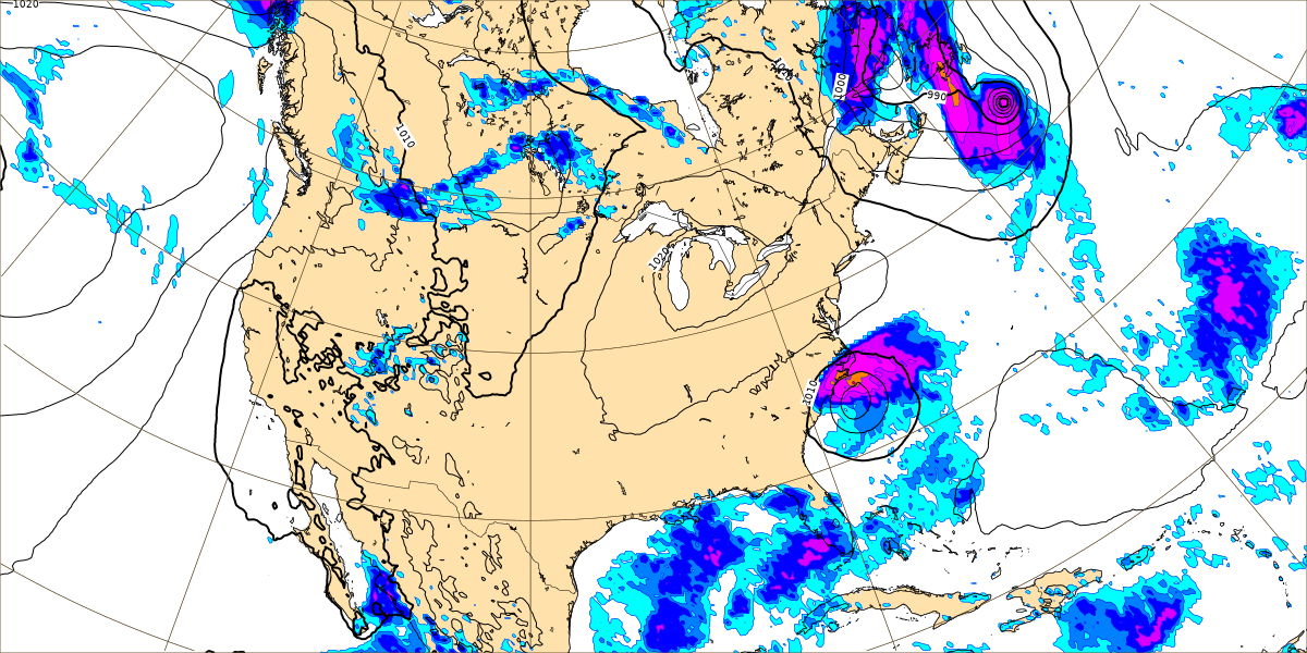
We actually have a frontal boundary clearing the region between Saturday evening and Monday morning. And you can't really see that on the raw model output.
But you can on these Weather Prediction Center maps.
For Sunday the High will probably drop to about 90 or so, Low of 70 or so.
On Monday the GFS is not showing much rain chance here.
But the NAM looks more realistic. Rain should stay isolated or widely scattered at least, about a 20-30% chance of any one spot getting wet. By Monday the High should drop into upper 80's, Low into upper 60's.
And again on Tuesday we are going to have to closely watch that tropical cyclone trying to get its act together in the Gulf. Could still see an isolated shower or two around here. Expecting a High in mid-80's and Low in mid-60's.
The ECMWF, often the most reliable global model for tropical systems, has the tropical storm (or hurricane) displaced farther to the East of what the GFS is showing.
The GFS shows rapid intensification and movement of that tropical cyclone, bringing it inland around Pensacola on Wednesday.
While the European model has it moving through Southeast Georgia, after having moved through that juncture of the Florida Panhandle and Peninsula. At this point, the system has not even formed a tropical depression yet, and no aircraft has gone in to investigate it. So the models are working with limited data.
Around here, Wednesday should bring us a dry reinforcing front. So skies should become sunny again, with temperatures edging more down toward lower 80's/lower 60's.
Also if we're Northwest of a landfalling tropical cyclone, that tends to promote milder, drier air up this way.
But here it gets crazy. The GFS latest run brings the tropical cyclone up through Alabama. If that were to somehow verify, then of course we are rainy and windy.
And the ECMWF has it just off the East Coast of the Carolinas. So you see the forecast dilemma. Actually I'm pretty sure the European is closer to having this right. The GFS scenario is unlikely, especially with that front.
So expecting mostly sunny skies here Thursday with a High in lower 80's, Low maybe down close to 60.
And the model guidance has already gotten so goofy that I'm not showing the rest of it for this forecast period. Just briefly will note that for Friday the High may rebound to about mid-80's, but Low probably staying 60 or so. And basically the same for Saturday, but Lows may rebound further into lower 60's.
Looks like Tropical Storm Franklin will ramp up to hurricane strength over favorable waters and pass West of Bermuda Monday through Tuesday.
But the main feature that everyone in Florida, Western Cuba, and the Yucatan Peninsula should be watching, is this tropical cyclone trying to form as it moves from the Caribbean Sea into the Gulf of Mexico. It will most likely affect either the Florida Peninsula or Panhandle, regardless of to what extent it strengthens before making landfall. It will probably make landfall between Tuesday and Thursday of next week.

The tropical models are favoring the ECMWF solution more, but a couple do take it further West like the GFS wants to. I also noticed the tropical models mostly keep this at tropical storm strength before landfall, but I wouldn't read too much into that. It depends on several factors, including how fast it moves. The waters of the Gulf are very warm and favorable for rapid intensification of any tropical cyclone that forms. And this has not quite formed into a tropical cyclone yet, not even a depression. So any forecasts are working with limited data. Forecasts will be better once someone has flown into this thing and taken observations, to give the computer models and human forecasters more to work with. But confidence is growing that Florida will be affected by some level of a tropical cyclone next week, probably between Tuesday and Thursday.

Rainfall amounts around here for this forecast period will probably average under a half-inch, and for most of us, probably only up to a tenth or a quarter of an inch. Of course heavy rains are expected wherever this tropical cyclone ends up, whether it does remain at tropical storm strength or whether it becomes a hurricane.


No comments:
Post a Comment