Tuesday (High 83, Low 69): Partly to mostly cloudy. Numerous showers and thunderstorms are possible throughout the day.
Wednesday (High 82, Low 66): Partly to mostly sunny. Breezy.
Thursday (High 83, Low 62): Sunny. Mild and dry.
Friday (High 82, Low 64): Mostly sunny with a 20% chance of a passing shower or thunderstorm.
Saturday (High 85, Low 65): Sunny.
Sunday (High 87, Low 66): Sunny.
Labor Day (High 90, Low 68): Sunny.
Much of the Florida coast has been placed under a Hurricane Warning for Tropical Storm Idalia, which is expected to strengthen to a major hurricane before making landfall some time tomorrow night or Wednesday morning. People in the path of this hurricane need to go through their hurricane safety plan as soon as possible. Some evacuation orders have been issued, and this is a situation where even if evacuation was voluntary, I believe I'd do it.
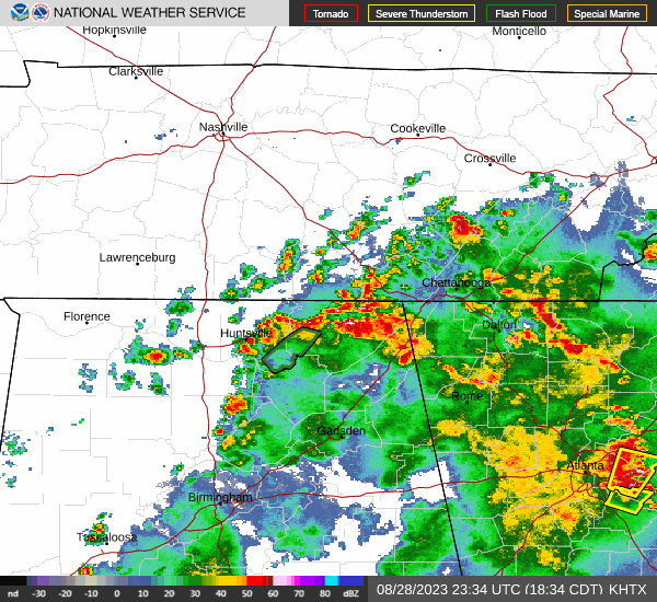
Locally we had more clouds than sun overall in Cullman today with periods of rain and thunder. The High was only 84, and the Low this morning was 72.
And the rain was a little more widespread today than expected. I guess the NAM model got that right this time. Got a flash flood warning currently in effect for Southeast Madison County and West Central Jackson County. And they are also having issues with flash flooding over in Atlanta.
So the front has stalled out. And we are watching two hurricanes, although one is not a hurricane yet, the one that could bring a lot of damage to Florida tomorrow night or Wednesday morning.
Tomorrow should be similar around here.
The NAM again shows more of a rain chance. I think a 50% chance of rain is reasonable based on what we saw today and this model guidance. High should be about 83 or 84, and Low should be about 70 or 69.
Then as Hurricane Idalia makes landfall overnight, we'll be on the dry side Wednesday. And I'm not even going to include any rain chances here. Skies should be mostly sunny with a High in the lower 80's, low in mid-60's. But we will get a good breeze, winds could gust up to 15 or 20 miles per hour at times.
By Thursday we should see sunny skies with a High in the lower 80's, Low in lower 60's.
Similar weather for Friday except the Low might be more toward mid-60's with a minimal 20% chance of a passing shower or thunderstorm, as we get some return flow from the Gulf of Mexico.
After that, the high pressure starts to build back over the region, keeping skies sunny, but the heat won't return all at once. Saturday looks to have a High in mid-80's, Low in mid-60's. Then for Saturday, the High should be in the upper 80's.
We should be back to about 90 degrees for Labor Day, but that still is more seasonable and not the excessive heat we had for a while.
In the tropics, we have Hurricane Franklin and Tropical Storm Idalia. And we also have another disturbance coming off the West coast of Africa that isn't going to anything within the next couple of days, but might develop into a tropical depression over about the next week as it moves West across the Tropical Atlantic. It may have a Northwest component to its motion at times, but we'll have to wait and see what it does.
Hurricane Franklin is a major hurricane with sustained winds of 150 miles per hour. It is only expected to come close enough to Bermuda to cause tropical storm conditions. They are under a Tropical Storm Watch. This hurricane is also causing dangerous surfing conditions/rip currents along the East/Southeast coast of the United States mainland.


Tropical Storm Idalia has not yet become a hurricane, but is still expected to fire up to a major hurricane before the eyewall makes landfall probably in the Big Bend region of Florida, where the Peninsula meets the Panhandle. Even people further inland in a place like Jacksonville can expect hurricane impacts from this. And please remember that on the Eastern/Northeastern side of a hurricane, the weather can be severe a long way from the center of the storm. Especially with a major hurricane like this is expected to become, even those outer spiral bands can be really dangerous, with potential for flash flooding, high winds, and isolated tornadoes.
In fact, the Storm Prediction Center has gone ahead and issued a severe weather outlook for tomorrow and Wednesday, people who will be on that East/Northeast side of this hurricane, for a risk of tornadoes and damaging winds.
Also need to keep in mind that storm surge and flooding can happen some distance from the actual eyewall, even if the places hit by the eyewall usually get the worst of it.
Anybody under the Hurricane Warning in Florida, I would recommend evacuating or finding the nearest public shelter before this thing moves in. Few homes are going to be strong enough to withstand the impacts, at least close to the coastline, in my opinion.
Of course very heavy rains and flooding issues are expected along the track of this hurricane. Back here at the ranch, our rainfall amounts will probably average a quarter-inch or less for this forecast period.
By the way, even though places like Mobile and Pensacola, Panama City, are not expected to be on the rough side of this hurricane, it is close enough that conditions will be very unsafe for surfing, really bad rip currents likely. The weather down there is expected to be unsettled for this period, about a 50% chance of rain and thunderstorms each day, but seasonably hot, Highs in lower 90's and Lows in mid-70's most days.


No comments:
Post a Comment