


Most of the storms are staying elevated, but here Huntsville is under the gun for damaging winds with this one. Looks like the forecast was spot-on for isolated severe thunderstorms tonight.
3:10 - By the way, the lightning is fierce in these storms, even the ones that are not showing any signs of being severe. I'm staying away from windows and electrical stuff for a while. But if you like to live dangerously, you might prefer to do a little jig on the back porch . . . who am I to judge?
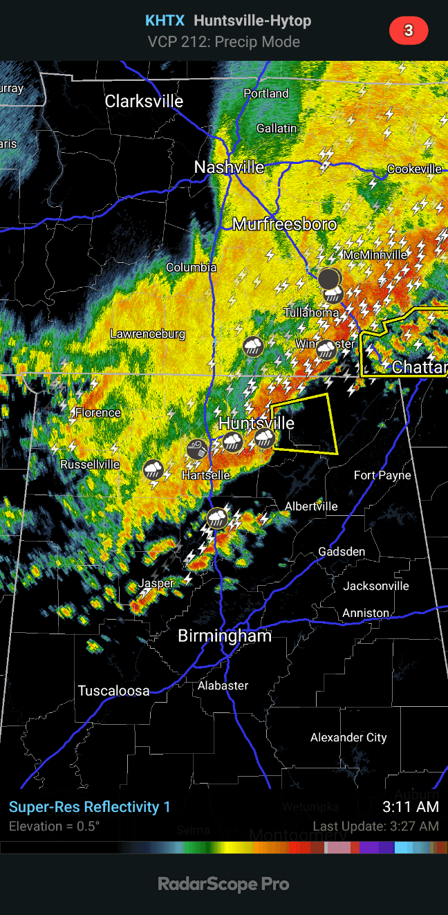
3:28 - These storms are moving really fast. Scottsboro is now under the gun for severe winds. And they also have a part of the line showing severe winds up around Chattanooga, Tennessee, worth a mention.

3:38 - Even as these storms move into places like Albertville, Boaz, Fyffe, Fort Payne, winds of 50 miles per hour are pretty strong. And it would be sensible to stay away from windows while these storms come through.
3:46 - The warning has expired. The storms outran the polygon anyway. As usual, Ben Smith does excellent severe weather coverage. He's been around a long time. I've seen old footage of him from some of the classic events, can't remember if it was the 1989 Huntsville tornado or maybe the Palm Sunday outbreak in the early 1990's.

4:05 AM - The storms are all under severe limits now. They've split into two lines.
Severe Thunderstorm Warning
ALC071-089-095-100845-
/O.NEW.KHUN.SV.W.0229.230810T0758Z-230810T0845Z/
BULLETIN - IMMEDIATE BROADCAST REQUESTED
Severe Thunderstorm Warning
National Weather Service Huntsville AL
258 AM CDT Thu Aug 10 2023
The National Weather Service in Huntsville Alabama has issued a
* Severe Thunderstorm Warning for...
North central Marshall County in northeastern Alabama...
Western Jackson County in northeastern Alabama...
Central Madison County in north central Alabama...
* Until 345 AM CDT.
* At 257 AM CDT, a severe thunderstorm was located over Marshall
Space Flight Center, or near Madison, moving east at 50 mph.
HAZARD...60 mph wind gusts.
SOURCE...Radar indicated.
IMPACT...Expect damage to roofs, siding, and trees.
* Locations impacted include...
Huntsville, Madison, Scottsboro, Redstone Arsenal, Moores Mill,
Owens Cross Roads, Skyline, Gurley, Woodville and Triana.
PRECAUTIONARY/PREPAREDNESS ACTIONS...
For your protection move to an interior room on the lowest floor of a
building.
&&
LAT...LON 3460 8678 3478 8677 3489 8610 3455 8603
TIME...MOT...LOC 0757Z 272DEG 43KT 3469 8668
HAIL THREAT...RADAR INDICATED
MAX HAIL SIZE...<.75 IN
WIND THREAT...RADAR INDICATED
MAX WIND GUST...60 MPH
$$
GH


No comments:
Post a Comment