Tonight (Low 59): Rainy and windy. Thunderstorms are also possible, and some may become severe.
Tomorrow (High 67): Rainy and windy. Rain could be heavy at times.
Wednesday (High 50, Low 42): Decreasing clouds with a lingering shower possible in the morning. Becoming partly to mostly sunny in the afternoon.
Thanksgiving (High 56, Low 33): Mostly cloudy and cold. Isolated showers are possible in the evening and night hours.
Black Friday (High 55, Low 43): Mostly cloudy with a 20% chance of showers - 90% chance of crazed shoppers and whacko drivers.
Iron Bowl Saturday (High 56, Low 41): Partly cloudy with a 50% chance of being around really-pissed-off football fans.
Sunday (High 55, Low 37): Mostly sunny.
Monday (High 54, Low 35): Mostly sunny.
For anyone who still saunters by this blog, confidence has increased that we will see some risk for thunderstorms to become severe tonight into early tomorrow morning.
It is still not expected to be a very big, widespread severe weather threat, around here. It is mainly a marginal chance for damaging winds, generally along and West of Interstate 65. Not to say we couldn't have something in Northeast Alabama, but the cold air damming effect from the Appalachian Mountains will probably help our folks out up that way and keep the air cooler and stabler.


Even in Northwest Alabama, it looks like it will be hard to get unstable air that far North.
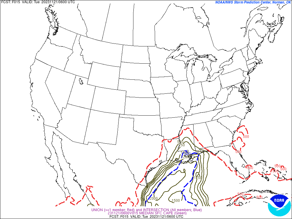
Showing the SREF here, but even the NAM is not any more aggressive in getting a lot of fuel for the atmosphere to work with, to produce rotating updrafts. This is between Midnight and Daybreak.
Meanwhile, the wind shear is crazy-high, as it often is in November. This is very common, to have tons of turning of the wind with height, but it's questionable whether or not we get the fuel to make the air rise and do anything (severe) with all this wind energy. It won't take much unstable air at all to work with, with this kind of wind shear.
And we also have a strong cold front coming through tonight into tomorrow. It will bring us down to the 50's for Highs by Thanksgiving and a Low around 30 degrees. Out ahead of it is that warm front. That warm front, how far North it lifts, will have a big impact on where the severe weather materializes. Sometimes storms even like to ride a frontal boundary in a borderline environment like this.
The greatest threat of tornadoes with this setup will be in Northern Louisiana into Southern Mississippi, where supercell thunderstorms are most likely to form. Then upstream, in North Alabama, we get the leftovers, with only a marginal 2% risk of having an isolated tornado, probably one associated with a squall line of storms ahead of the actual cold front at some point overnight. While this is not a major, widespread threat up our way, I would encourage everyone to respect it.
We are under a Wind Advisory and could see gusts up to 40-50 miles per hour even outside of any specific thunderstorms. Even places that get more of a cool rain in Northeast Alabama or up into Tennessee may see some winds strong enough to blow around outdoor objects or perhaps even do minor damage, mainly to trees.
We are at 70 degrees in Cullman right now, and our High probably will not climb much above that, might make it up to 72 or 73 for the day. We did get slightly warmer than forecast though. And that might mean the air is muggy enough to support a few more severe thunderstorms than what the models are projecting tonight too. Still the threat is borderline for North Alabama or any part of Southern Tennessee.
The overnight Low should be in the upper 50's. Very windy night in addition to the heavy rainfall and potential for a few storms, which could become severe.
After daybreak tomorrow, the threat for damaging winds or an isolated tornado is expected to shift more down toward Birmingham and points South and East. People down around Montgomery or Dothan will have the highest tornado threat, and even there, it is a basic isolated tornado risk of 5% within 25 miles of any given point.
Around here we'll just stay rainy and windy, rain could still become heavy at times, with a High near 67 degrees. The risk of thunderstorms is low, and the risk of any becoming severe tomorrow is very low.
Then Wednesday and Thursday (Thanksgiving), high pressure moves in behind the front, and so sunshine and cold air return.
But we will have enough residual moisture behind the front to keep some clouds in the forecast. Models now making it look like we'll see more sunshine Wednesday than on Thanksgiving Day, but still a mix of sun and clouds. High should be near 50, Low about 40 or so.
And the clouds might actually crowd out the sun on Thanksgiving for much of the day, which works out for most people, inside stuffing themselves and then taking a nap anyway. High should be in mid-to-upper-50's. It's now looking like the Low will be down in the lower 30's but maybe not below freezing because of the clouds hanging around, could prevent ideal radiational cooling overnight.
Then we have another low pressure system and front that could bring us some isolated rain Thursday evening and scattered rain at night. The models have been all over the place with it, driest has been GFS, and I tend to agree with that. Whatever rain we may get should be winding down Friday morning.
But skies will stay mostly cloudy with a High in the mid-50's, Low in lower 40's.
Some sunshine returns on Saturday but still quite a few clouds lingering, High in mid-50's again, Low around 40 or so.
Then finally by Sunday we'll likely see more sun than clouds, High still in mid-50's, but the morning Low being able to drop into the mid-30's because of the drier air, or at least into the upper 30's.


By the time I finished writing this, the Storm Prediction Center updated the threat areas slightly. Most of North Alabama is expected to only get general thunderstorms, and a lot of rain and wind, tonight, but keep in mind that these are only basic guidelines. Especially this time of year, you have to allow for the possibility of a few storms overperforming. Muscle Shoals is at 74 degrees now, Huntsville at 70, Decatur at 71. The dewpoints are in the 40's and 50's, and we need to see 60's of dewpoints to get severe weather. So it depends on what kind of airmass we have late tonight when this show gets on the road around here. The gradient winds outside of specific thunderstorms could cause isolated power outages on their own. And some isolated flash flooding could occur from this big dump of rain when we haven't had a decent rain in so long. This event will definitely help our drought.
As far as timing, any time between this evening and tomorrow morning is fair game for a thunderstorm to become severe in North Alabama or perhaps Southern Middle Tennessee. The better chance is in the southern counties like Cullman, Blount, Marshall, Winston, Marion . . . but can't rule anybody out of this marginal severe weather risk.
Most likely we'll see a few thunderstorms that produce damaging winds, enough to do minor damage to a structure or to take down trees and power lines, in the region. But an isolated tornado is also possible.
Remember to use a weather radio or WEA on your phone to get the warning reliably. Outdoor sirens don't cut it for overnight events.
Usually the cell phone wireless emergency alerts won't give you a severe thunderstorm warning, but they do give tornado warnings.
NOAA Weather Radio gives you all the alerts. Might want to check the batteries since power outages are possible tonight. Battery backup can help you out once in a while.
If you go under a Severe Thunderstorm Warning or Tornado Warning polygon:
* Be in a sturdy house or other strong building, not a mobile home.
* Stay away from windows.
* Get to the lowest floor.
* Try for a small room like a bathroom, closet, or even a hallway.
* Make that room as near the center of the building as you can.
And if it is a tornado warning, you might want to also shield your body in some way, especially your head, in case of falling or flying debris. It's best if you have a safety helmet, but if you can get up under a table, desk, set of stairs (something sturdy anyway) or have a couple blankets or a pillow, then that's also good enough.
Wishing everyone safety tonight and then a good holiday.
10:41 PM Update - The airmass in North Alabama and really most of Central Alabama has remained stable with plenty of rain coming in and cooling things. We are windy, but overall just a good night of beneficial rain and some gusty winds around here.
And I really am not concerned about severe weather up here anymore. The
latest mesoscale discussion from SPC is only concerned with severe weather being possible in Southwest Alabama. These cool-season setups are tricky that way. They did have some tornadoes back in Mississippi and I think Louisiana too. Around here it looks like we lucked out with this one.
Only real concern is for people out driving tonight, the heavy rains and high wind gusts could make things a little challenging. So any truck drivers that happen to read this, you probably already know how to be careful. Don't ever cross any water that covers a road or especially a bridge. If you can't see under the water, stop.


No comments:
Post a Comment