

(Forecast)
Sunday (High 66, Low 35): Sunny. Cold in the morning, cool the rest of the day.
Monday (High 69, Low 44): Breezy with increasing clouds and isolated showers possible during the day. Rain is likely at night, with a few thunderstorms possible - and a few storms could even become severe.
Tuesday (High 67, Low 55): Rain likely. Thunderstorms possible - and a few could reach severe limits.
(Extended Outlook)
Wednesday (High 53, Low 43): Partly to mostly sunny.
Thanksgiving (High 54, Low 37): Sunny with dead-but-yummy turkeys likely in many homes.
Black Friday (High 55, Low 38): Mostly sunny but with shopping and travel conditions possibly becoming severe anyhow.
Saturday (High 60, Low 39): Partly to mostly sunny with a 20% chance of showers.
(Pronóstico)
Domingo (Máxima 66, Mínima 35): Soleado. Frío por la mañana, fresco el resto del día.
Lunes (Máxima 69, Mínima 44): Ventoso con nubes crecientes y posibles lluvias aisladas durante el día. Es probable que llueva por la noche, con algunas tormentas eléctricas posibles, y algunas tormentas incluso podrían volverse severas.
Martes (Máxima 67, Mínima 55): lluvia probable. Es posible que se produzcan tormentas, y algunas podrían alcanzar límites severos.
(Perspectiva Extendida)
Miércoles (Máxima 53, Mínima 43): Parcialmente a mayormente soleado.
Acción de Gracias (Máxima 54, Mínima 37): Soleado con pavos muertos pero deliciosos probablemente en muchos hogares.
Viernes Negro (Máxima 55, Mínima 38): Mayormente soleado, pero las condiciones para las compras y los viajes posiblemente se vuelvan severas de todos modos.
Sábado (Máxima 60, Mínima 39): Parcialmente a mayormente soleado con un 20% de probabilidad de lluvias.
(Notes)
The National Weather Service in Nashville is still doing Weather101 classes.
While the risk for severe thunderstorms is low for North Alabama or Southern Middle Tennessee on Monday night/Tuesday, it still wouldn't hurt to review your safety plan, just in case of any problems.
(Discussion)


It has been a mostly sunny day in the Tennessee Valley with a Northerly breeze. The High in Cullman was 61 after a morning Low of 55. Jasper saw a High of 66 and a Low of 50. Haleyville had a High of 64 and Low of 52.
The clouds hung on until midday for Fort Payne, where they wound up with a High of 65 and Low of 53. Decatur had a High of 61 and Low of 53. Huntsville saw a High of 62 and Low of 54 there in the Rocket City. Muscle Shoals had a High of 65 and Low of 51.
Elsewhere around the region, Nashville had a High of 60 and Low of 50 there in the Music City. Memphis saw a High of 63 and Low of 46 today. And over at Chattanooga, the clouds hung around longer than for most of us today, but they still had a High of 68, morning Low of 58.
The cold front has cleared the region, and high pressure is moving in at the surface with Northwest wind flow aloft.
And it is going to be a cold one tonight, making it down to about 35 degrees by daybreak tomorrow.


The high pressure should move along to the Mid-Atlantic coast through the day tomorrow, and we'll have plenty of sunshine, High getting up to about 66 degrees in the afternoon, light North winds.


And it looks now like most of Monday during the day will be dry, the way the models have been trending. But clouds will be on the increase and winds picking up during the day. Could see isolated showers during the day, but the main rain event will come at night. The High on Monday should get up to about 69, doubt we'll make it to 70. Low rebounding to about 44 or 45 that morning as the moisture moves back in and prevents as much cooling.


The main rain event will be overnight Monday night into Tuesday. And the air looks like it will be unstable enough to support some thunderstorms.

Whether we see any thunderstorms reach severe limits is more dicey, and looks more likely for areas to our South and West, but we'll talk about that more later. Still expecting a High in the upper 60's on Tuesday and a Low in the mid-50's.


We should clear out on Wednesday, but models are now hinting at some clouds and maybe even an isolated shower hanging around behind the front. I doubt we'll see much in the way of rain, but I can see the clouds hanging around for at least about half the day. Still think we'll see some sunshine, more of a mix. High should be in mid-50's, Low in lower 40's.


Then the high pressure will settle in for Thanksgiving Day, and we'll start out about upper 30's and warm to about mid-50's again. We might see lower 50's for Wednesday, close call. Anyway mostly sunny skies should still be on tap for Thanksgiving.


As the high pressure shifts off into the Atlantic on Black Friday, we'll have Southwest wind flow aloft. Still think we stay mostly sunny. Temperatures should rise into upper 50's, probably see upper 30's again for the Low.
Not worried about the weather this coming Friday, but definitely advise everyone to look out for maniac driver and shoppers. My cat, Salem, has already told me he intends to sleep in that day, and that he fully expects treats for the weekend to follow. His hip is healing up pretty well as far as I can tell, though he still limps a little once in a while. Vet is supposed to check him again toward the turn of the month. He definitely has his fiery nature back by now and is back to playing rough, whether it's one of his toys or my hand. And he tromped through some paint and licked it off his paw yesterday. Fortunately it was acrylic and nontoxic. He didn't upchuck or show any discomfort other than smacking his lips at the unusual taste.


Then the weather just isn't that clear for next Saturday. The GFS is showing a closed Low up around the Great Lakes but us starved for moisture down here except along the Gulf Coast.

While the ECWMF shows another system approaching us from out West. Will reintroduce a chance for an isolated shower, but overall we should be partly to mostly sunny, High near 60, Low in upper 30's or about 40.
This is a dynamic time of the year for weather around here, and you have to take these systems one at a time sometimes. Here the seventh day of the forecast is an educated guess at best.
That system in the Caribbean did not develop into a tropical cyclone after all. And the tropics are quiet here at the end of hurricane season.

It looks like the main severe weather threat for Monday will be over Central and Southern Mississippi, back into Louisiana, Southern Arkansas, and even East Texas. But some marginal risk for severe thunderstorms has already been extended to far West Alabama for Monday night into Tuesday morning by the Storm Prediction Center.
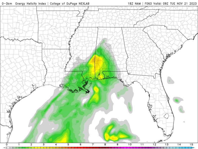

Right now the NAM is showing the best combination of instability and wind shear being at about 3 AM Tuesday during the dark hours. And the NAM does show a line of storms moving through overnight between Monday and Tuesday. Glancing at the SREF, it keeps the unstable air farther to the South. But it is always a close call this time of year. Some instability could make it into North Alabama, enough to combine with ample wind shear and lift with this system, and cause a few thunderstorms to become severe between Monday night and Tuesday. It's nothing to be overly alarmed about, but it is worth keeping an eye on. If you've got people travelling in from other states who are not used to the storms we can have this time of year, might give them a heads up. Even if the unstable air does stay to our South, this is going to be a soaking rain. Which of course we really need right now.

Most of us should see an average of 1.5-2 inches of total rainfall during this forecast period. And of course we need it. We've been in drought too long, and this will help.
All right, thanks for reading, wishing you well for the holiday week.


No comments:
Post a Comment