

FORECAST:
Friday (High 70, Low 36): Sunny. Mild during the day - cold with patchy frost possible in the morning.
Saturday (High 75, Low 46): Mostly sunny. Mild and breezy.
Easter Sunday (High 78, Low 55): Partly cloudy. Warm and breezy.
EXTENDED OUTLOOK:
Monday (High 80, Low 60): Mostly cloudy.
Tuesday (High 74, Low 63): Thunderstorms likely - a few could become severe.
Wednesday (High 62, Low 47): Mostly sunny.
Thursday (High 66, Low 40): Sunny.
PRONÓSTICO:
Viernes (Máxima 70, Mínima 36): Soleado. Templado durante el día, frío con posibilidad de heladas irregulares por la mañana.
Sábado (Máxima 75, Mínima 46): Mayormente soleado. Suave y ventoso.
Domingo de Pascua (Máxima 78, Mínima 55): Parcialmente nublado. Cálido y ventoso.
PERSPECTIVA EXTENDIDA:
Lunes (Máxima 80, Mínima 60): Mayormente nublado.
Martes (Máxima 74, Mínima 63): Es probable que haya tormentas eléctricas; algunas podrían volverse severas.
Miércoles (Máxima 62, Mínima 47): Mayormente soleado.
NOTES:
There was a recent Public Television Special on the Blizzard of 1993. Worth watching.
The National Weather Service in Nashville is continuing Weather101 Classes through April and May. These are good classes, enjoyable, and they are free.
The Weatherbrains podcast had an excellent show this past Monday about the April 3-4, 1974 tornado outbreak. Along with the April 27, 2011 event, this is generally considered the worst our region has ever seen. I haven't finished listening to it yet, but it has Greg Forbes and Ken Graham and is just a great discussion. For any who don't know, Dr. Forbes studied under Theodore Fujita, who was the main inventor of the F-scale for rating tornadoes. I believe they may continue it this coming Monday, that it is a two-part discussion. This coming Monday, of course is April Fool's Day. Footnote: A lot of people don't remember, there was actually a tornado event April 1, 1974. And one guy in the Weather Service told another: "If you didn't like the one on the 1st, you're really not gonna' like what we've got coming on the 3rd." Likewise, the April 2011 event had a preliminary event on April 15th, which a lot of people don't remember. And then of course we had the far worse event on the 27th.
While we certainly do not expect a severe weather outbreak of that magnitude during this forecast period, any severe weather threat is worth taking seriously and respecting. And April tends to be our worst month for that. We will have to watch this coming Tuesday. For now it just looks like a basic risk that may or may not play out around here, North Alabama and Southern Middle Tennessee, but I would still encourage everyone to review safety plans for severe thunderstorms and tornadoes. To be on the safe side. If you live in a mobile home, you need a plan to go somewhere safer in enough time, if a tornado or really dangerous thunderstorm is coming at you in one of these events. Not trying to scare anyone since was just talking about the really rare, horrendous tornado outbreaks, but even a lower-end or basic threat for severe thunderstorms deserves to be taken seriously. If we only have one tornado or one damaging thunderstorm that happens to come down your street, then you'll be glad you were prepared. And we really have to wait and see at this point, if any of our region will have a higher or lower threat for specific hazards with the storms. For now we're just blanketed with a basic severe thunderstorm risk that depends on a lot of variables. It's typical for this time of year. And I'm spending a lot of words to let you know not to get overly anxious or excited about it, but to treat it with a reasonable amount of caution, keep up with the latest forecasts and have a safety plan in case you do need it.
At some point this weekend I may write up my own version of severe weather safety, but no promises there. The government stuff is more succinct. Main things I wish people would do are to rely on weather radios instead of outdoor sirens and make sure to be able to get out of a mobile home safely ahead of a storm that is trying to produce a tornado or serious wind damage. If you have a sturdy house or something like a storm shelter, maybe offer it to people that you know are in trailers or other weak structures. Somebody in my family used to do that, and it can really help people out. Severe weather is just a fact of life around here.
And after hearing Troy Kimmel and that really nice lady from the Weather Channel whose name escapes me now talk about the need for bilingual forecasts, I'm trying them in Spanish sometimes again. As far as trying 10-Day-Outlooks, usually not going to in the Spring season. The weather is too dynamic, and it's even less reliable than usual beyond seven days. Most the local TV stations have backed off on doing those anyway, and that was the only reason I tried it, I think last year, to sort of have fun with it and experiment, see if any accuracy was possible that far out.


Skies were sunny today in the Tennessee Valley with a North/Northwest breeze. The High in Cullman was 63 after a morning Low of 41. Jasper saw a High of 68 and Low of 43. Haleyville saw a High of 64, Low of 40 degrees today.
Decatur had a High of 66, Low of 38. Huntsville got up to 65 after a morning Low of 42. Then looking up across the Tennessee border, Fayetteville had a High of 63 and a Low of 39. Winchester had a High of 61 and a Low of 36 degrees. And then finally Nashville had a High of 64 and a morning Low of 41 today.
We have such strong high pressure in place that it has been hard to find a cloud in the sky. It is looking like a lovely holiday weekend, does look warmer than we've been so far this year.


We'll stay sunny tomorrow, High of about 70, a Low of about 36 to start the day. And patchy frost is possible, especially in Tennessee counties. Winds will have settled down, only a light breeze at times, nothing like today's.


Saturday we'll stay mostly sunny as the high pressure system pushes off into the Atlantic. Our upper-level winds will go more zonal, and our winds will start to pick up again, we'll be breezy this weekend. We'll have more moisture return, and our Low should start the day in about the 45-48 degree range, and then we'll warm to about 75 in the afternoon.

Then on Sunday, which is Easter, we'll still be between the high pressure system and our next cold front way back West of the Rockies. We'll get some winds and some moisture in here. Not expecting any rain, but we'll see a good mix of clouds again, along with plenty of sunshine. Highs should get into the upper 70's, or a few spots may see 80, especially as you get closer to Birmingham, or wouldn't be impossible for Huntsville, that urban heat island effect. I'm forecasting for Cullman here. Expecting upper 70's there and for most places. The Low should be in the mid-50's. And it is expected to stay breezy. So that might add to the fun of some people's holiday plans outside. Overall the weather looks great for everything, just a pretty good breeze.

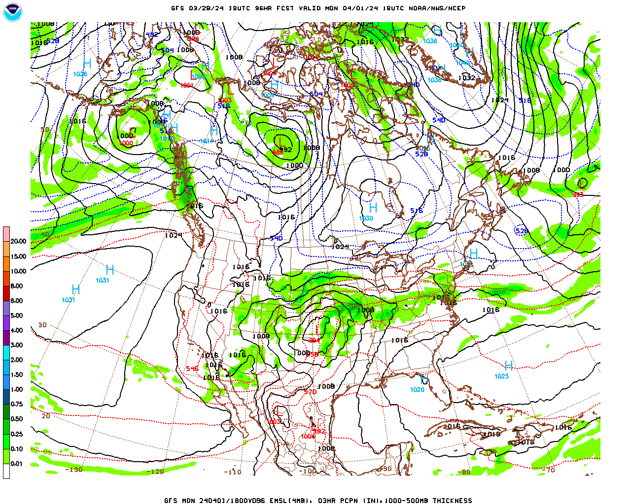
On Monday, that cold front will be moving through the Plains and perhaps affecting the Midwest and Ohio River Valley.

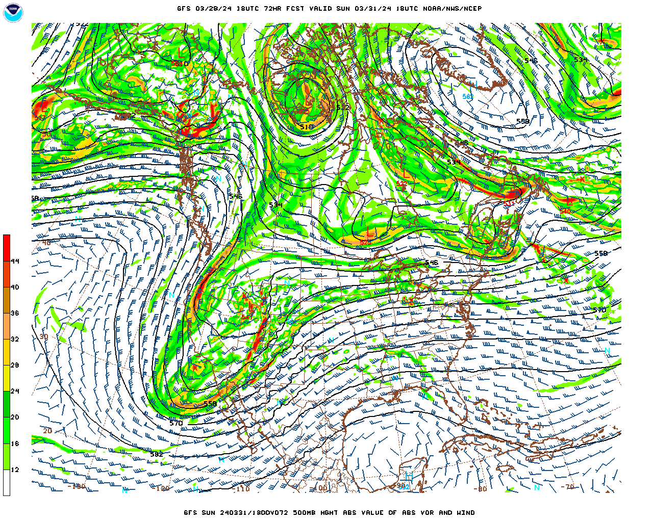
And there is a risk for severe thunderstorms with this system. Above you can see the most likely areas to have thunderstorms become severe on Monday. So if you're travelling or know people in these places, it is a heads up.
Around here, our clouds will increase and we'll be breezy again, High near 80, Low near 60. We could start to see some rain and even thunder Monday night, but even if so, those storms are not expected to reach severe limits in the Southeast/Tennessee Valley Monday night.


Tuesday we'll have to watch around here though. Here is the GFS bringing some rain along and ahead of that front as early as 1 PM.

But the timing is in question. If the ECMWF solution is right (as it often is this time of year), we're looking at more like a Tuesday evening/night rain and thunderstorm event.
We'll have a High in the lower-to-mid-70's and a Low in the lower 60's, maybe mid-60's.


If we can rely on the model guidance at this point, it looks like we may have moderate instability but only marginal wind shear to support severe thunderstorms and storms that rotate. It is pretty early to be trying to nail down specifics.

But the Storm Prediction Center has gone ahead and put us in North Alabama and Southern Tennessee under a basic risk for severe thunderstorms for Tuesday/Tuesday night. And that risk actually covers nearly all of Tennessee and Kentucky. The basic idea is on the table that severe weather is possible across this broad area.


On Wednesday we'll quickly become mostly sunny again, could see lingering showers in the morning, the European sort of suggested that. The High should only be 60 or so, the Low dropping back into mid-40's or at least upper 40's again. Pretty typical cold front for this time of year.


Then on Thursday we have high pressure settling over the region strongly again. We'll have clear skies and pretty dry air in place, so a High in the mid-60's and Low near 40.

And this system on Tuesday probably won't bring most of us all that much rain. Most of us will see an average of about half an inch of rain, a few areas in Northeast Alabama up into Southern Tennessee may see higher totals closer to an average of one inch of rain.
You can always have locally heavier rain if a storm becomes severe, of course, but that is very speculative at this point. Will include links to review severe weather safety in the notes, although I have not written up my own version of it this year. Think I did last Fall. Not sure how much I'll be on this blog in the near future, but had a chance to write something tonight, and thought it was a good time since we have the holiday weekend coming up and then maybe some strong storms on Tuesday or Tuesday night.


No comments:
Post a Comment