

FORECAST:
Today (High 82): Partly to mostly sunny with an isolated shower or thunderstorm possible during the day. Numerous showers are possible at night.
Friday (High 80, Low 63): Partly to mostly cloudy. Scattered showers and thunderstorms are possible.
Saturday (High 70, Low 55): Partly to mostly cloudy and turning cooler. Widely scattered showers are possible.
Sunday (High 58, Low 49): Overcast and cool. Numerous rounds of showers are possible.
EXTENDED OUTLOOK:
Monday (High 67, Low 42): Mostly sunny.
Tuesday (High 74, Low 44): Sunny.
Wednesday (High 78, Low 50): Mostly sunny.
PRONÓSTICO:
Hoy (Máxima 82): Parcialmente a mayormente soleado, con posible lluvia o tormenta aislada durante el día. Por la noche son posibles numerosos lluvias.
Viernes (Máxima 80, Mínima 63): Parcialmente a mayormente nublado. Es posible que se produzcan lluvias y tormentas dispersas.
Sábado (Máxima 70, Mínima 55): Parcialmente a mayormente nublado y volviéndose más fresco. Es posible que se produzcan lluvias muy dispersos.
Domingo (Máxima 58, Mínima 49): Nublado y fresco. Son posibles numerosas rondas de lluvias.
PERSPECTIVA EXTENDIDA:
Lunes (Máxima 67, Mínima 42): Mayormente soleado.
Martes (Máxima 74, Mínima 44): Soleado.
Miércoles (Máxima 78, Mínima 50): Mayormente soleado.
Jueves (Máxima 79, Mínima 54): Parcialmente nublado.
NOTES:
If you know anyone, kids or adults, who are interested in learning more about the weather, please let them know about the National Weather Service in Nashville's Weather101 classes. I took one about weather observations in three dimensions yesterday, and these are just great - free, interactive, great presenters, cannot recommend them highly enough.
Here is a look back at some of the local weather highlights of 2023.
And the Weatherbrains podcast took an interesting detour this week. The guest was Heather Tesch, who has retired from meteorology and now hosts a podcast of her own about people who have had near-death experiences. I appreciated this show, if only for the novelty of hearing a respectful, tolerant discussion of religion/spirituality without any political blim-blammering thrown in, and with honest questions encouraged. It sort of reminded me of Art Bell's classic show, not the diluted George Noory version of Coast to Coast, but when it was "real".
One time I heard a preacher in Winston County say that if you try to talk about death in everyday life, "you'll clean a house out!" But Ms. Tesch showed a knack for doing exactly the opposite. Everyone on the panel found the discussion interesting, and it brought out the best in everyone. I agreed most with Neil Jacobs, who expressed skepticism about his own experiences, not eager to put them into a neat little box. But I was still amazed that such a conversation could happen and stay so classy in this day and age, when I can't help but notice that people basically want to burn J.K. Rowling at the stake, for very different reasons than they wanted the same thing about 20 years ago. And that's only one example. I'm sure you can think of others that probably mean more to you and highlight just how whacko everything has become. This show was the opposite of whacko, and I would encourage anyone to give it a listen, even though it has little to do with the weather. As James Spann and others mentioned on the show, scientists are human beings too. And there is something spiritual about the quest for knowledge. Not to mention that the science of meteorology often involves trying to save people's lives, or to help people cope with the aftermath of storms. I really liked how this lady brought the two worlds together and also how Troy Kimmel and James Spann shared their thoughts, and encouraged everyone else on the show to. I remember Troy (who hosted the show this week instead of Bill Murray) saying of one point Heather made, "I've never thought of it that way . . . but I like it."


At 4 AM it is foggy and misty in Cullman with a temperature of 66 degrees. The dewpoint is also 66 degrees, making the relative humidity 100%. Winds are calm and have generally been light out of the South overnight. Barometric pressure is 30.09 inches and steady. The visibility is down to 2.5 miles and at times has dropped to less than a mile. Definitely a morning to be careful driving in to work.
It is also foggy in Jasper with a temperature of 66 degrees, 100% relative humidity there too. Winds are calm. The pressure is holding steady at 30.07 inches. The visibility is down to 0.15 of a mile. So just about nil.
Fort Payne is also foggy with a temperature of 59, visibility down to 3/4 of a mile. Decatur is overcast and 68 with a perfect visibility of 10 miles, by way of contrast. Huntsville is overcast and 67, the visibility down to 8 miles there. Muscle Shoals is overcast and 69. Tupelo is foggy and 68, visibility of 2 miles. Memphis is overcast and 71, visibility of 7 miles. And Nashville has a visibility of 10 miles, overcast and 69 degrees this morning.
I am having terrible technical difficulties with this computer and the post editor on this site this morning. It makes me want to shout the kinds of words that my dearly departed Papaw used to hurl at the cars in his garage, fine mechanic though he was. And then I think of him after he sobered up (on his own, by the way, after decades of regular drinking - very admirable), how he'd still growl a little bit, but then shrug and say, "Well, there ain't nothin' I can do about it." And move on. And the rest of the world is suffering far worse technical difficulties on a larger scale. The National Weather Service has suffered several radar outages and disruptions in graphics being updated properly here lately. And tonight, I saw where several states had interruptions in their 911 systems. I know that system started in Haleyville, don't remember what year exactly, but it's something we've come to take for granted. I am disturbed by how often technology is failing these days in odd, random ways. But I'm not the tech expert in the family by any means. And the people who are such experts tend to be so proud of it that they choose not to share much of their expertise with me. So I really don't know how unsettling these trends should be. I just know that seeing those news stories makes me think that we need to have some backup plans in case the grid ceases to function as we know it. If people can attack little old ladies in grocery stories over toilet paper just four years ago, then major disruptions could ensue if we have outages worse than these previews we've been seeing lately.
Anyway if some of the text and graphics above are still out of alignment and messy, I fought with it the best I could.
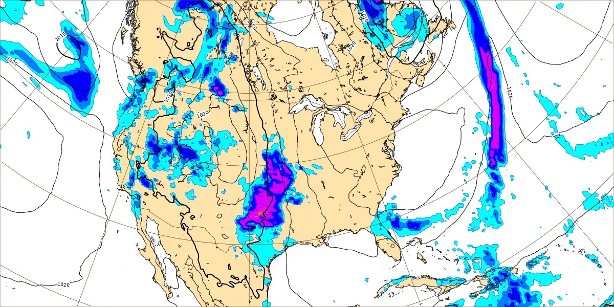
Our weather pattern is kind of interesting for April right now, with a ridge of high pressure keeping most of the thunderstorms deflected to our North for now. We definitely saw some rain yesterday, but even for the Nashville area, those low-end severe weather forecasts busted.
Today really looks like we'll see more sun than clouds overall, with only a low chance for isolated rain or a thunderstorm around here, the High in the 80-83 range.
Most of our rain should hold off until tonight, meaning Thursday night. It's still dark out as I type this.


Then even tomorrow, it looks like the rain and storms will be somewhat scattered over the region throughout the day. Look for a High near 80, Low in the lower 60's.


Then the front drops to our South on Saturday, and it still looks like the rain showers will stay fairly isolated, not a big widespread rain event. Look for a High near 70, Low down in the mid-50's.


Then the GFS (shown above) and the ECMWF remain aggressive in showing one last wave of this system that will pack a punch as far as ramping up our rain chances for Sunday. So will bump up the rain chance to 50% for Sunday, numerous rounds of showers possible, a mostly overcast day, look for a High in the upper 50's, Low in the upper 40's.


Then on Monday high pressure moves back into the region, and with it, sunny skies, a High in the upper 60's and Low in the lower 40's.


Another sunny day Tuesday, with the High making it into at least the lower 70's, might see some mid-70's. The Low should be in about the mid-40's.


The ECMWF makes that front look pretty weak and starved for moisture.
But the GFS handled this last system better. And this is typically the most active weather month of the year.
Let's move on to Thursday before making a decision about how to handle this forecast for Wednesday.


The GFS shows that front struggling and washing out on Thursday, not bringing us much rain.

For now I think both days, it's best to just blanket them with a mention of an increase in clouds. There is not enough evidence to bring in a 20% rain chance yet. Almost, but not quite.
Although as I look beyond the seven day period, I wonder if that needs to be reconsidered. The extended does look unsettled from Wednesday on, just the whole pattern, at least via the GFS.
For now let's say Wednesday we'll look for a High in the upper 70's, Low near 50. Then for Thursday, again a High in the upper 70's, the Low in the lower to mid-50's. Both days I think I'll introduce a 20% chance of rain after all.
And here's why . . .


The GFS continues an unsettled look as we get into next Friday.
The ECMWF keeps playing it conservative, but as much respect as I have for this European model, I don't think it keeping us dry for this length of time is as realistic for this time of year as the more unsettled pattern advertised by the American model.
So if we have to guess for Friday the 24th, that would look like an unsettled pattern, maybe bumping the rain chance up to 30-40%. Since it's so far out, probably go conservative with 30%. And the High should be near 80, Low in the mid-to-upper-50's.


Then for Saturday it moves the rain out of here, so it shows a more quick-hitting system. Which would mean the higher rain chance for Friday might have been the better idea after all.


Would expect a High near 80, Low near 60.
And these rain chances are going to be tough to adjust. It just looks unsettled and like the models are not handling it well, sort of like they don't handle summer patterns too well.


By the way, can't resist a comment here: I saw where one TV station is predicting isolated morning rain on this Saturday that is 9-10 days out. Nobody on the planet has that kind of accuracy in a pattern like this. Not even John Edwards or whoever the most famous "psychic" is now knows that. That's a guess . . . it's not even educated at that point. That is pure showmanship.
Okay, but here is the GFS look for Sunday. And it has us dry. And this would be the 28th.
No reason to adjust the temperature forecast much, High near 80, Low near 60.
And I'm going to leave days 8-10 out of any sort of official forecast this time. This time of year is too dynamic, and the models diverge enough even at days 6-7 here.
It was worth looking beyond seven days just to try to decide what to do about the crappy model guidance in the extended outlook.
Going to trend toward climatology and only reintroduce a rain chance of 20% for Thursday, leave it out for Wednesday.


We'll probably see about an inch of rain on average in the region between now and Sunday. This technically is for the next seven days, but the risk for additional rainfall Wednesday or Thursday is looking very low.
In the end decided to cut rain chances out of this forecast altogether. Decided between the GFS, ECWMF, and my overall impression of this pattern, the chance is less than 20%, so not worth mentioning in a forecast when we've just had a rainy weekend.


No comments:
Post a Comment