We may see a few more storms like this through the evening, but this warning was issued for the size of the hail, not even for possibility of wind damage.
3:59 PM - There is another strong thunderstorm over Northwest Huntsville that may produce gusty winds up to 30 mph or so and some smaller hail, like pea-sized. That is well below severe limits. And there is a thunderstorm in Lawrence County (Tennessee, not Alabama) that is behaving itself.
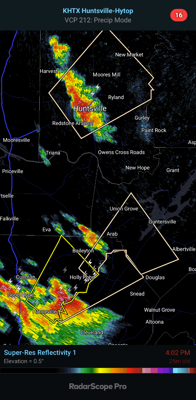
4:03 PM - For storms like this, you don't have to take tornado-level precautions. Basically just stay inside, away from windows or anything electrical, and you'll be fine. I wouldn't try to drive through them though. Even quarter-sized hail, gusty winds, and lots of lightning would be enough to make me want to pull over somewhere and let it pass.
4:07 - Now a special weather statement has been issued for Northern Blount County, affecting places like Blountsville and Strawberry. Most of any storms we get this evening should stay below severe limits, and the hail in this Cullman County storm just barely made it there. But it did verify with some pictures I saw scrolling social media. That storm up across the TN state line is not only staying below severe criteria but looks more like a shower at this point, not even seeing lightning with it now.
4:12 - This storm definitely verified with some severe hail as it moved through Dodge City. But just to be clear, the wind gusts are expected to stay about 30 mph with this. The warning was issued purely based on the size of the hail.
4:15 - And let me just go ahead and eat my words! Trees and powerlines have now been reported down in Hanceville by emergency management. Mentioned in the update to the warning, now expecting wind gusts up to 60 mph. So this storm is worth watching as it moves northeast. So I'd try to get away from windows in a house, better if you are on the lower floor. If you've got trees around, might want to move to a smaller space like a hallway just in case one were to fall. It's tougher for them to collapse the walls than in an open area like a living room or kitchen.
4:20 - And that storm is up to Holly Pond now. The one moving through Huntsville is staying below severe limits.
4:28 - As the storm moves up toward Arab, only wind gusts up to 40 mph and pea-sized hail are expected. So this Severe Thunderstorm Warning is being replaced by a Special Weather Statement as the storm tracks Northeast.
4:31 - Going to drop real-time weather coverage since these thunderstorms are fairly isolated and none are severe anymore.
4:37 - Most of the news I find depressing and pointless to comment on. But I did see a lovely story from WBRC/FOX-6 in Birmingham today.
I really think the world would be a better place if there were more women with this kind of gumption. If it was up to me, the cheating husband and mistress would be the ones arrested. That guy should count himself lucky he only got shot in the leg, it was easy to fix. And that other woman was not a victim at all. Standards have become so upside-down. And if you look at that woman's mugshot, any guy who was cheating on her had to be an idiot anyway.
Lest anyone think I've become a feminist, I fully supported Johnny Depp over Amber Heard. So as usual, both sides of popular debate are free to hate on me. I find it fun.
Glad the weather calmed down enough to speak of more pleasant things. Some country music might hit the spot this evening . . .
Severe Thunderstorm Warning
ALC043-182130-
/O.NEW.KHUN.SV.W.0029.240418T2041Z-240418T2130Z/
BULLETIN - IMMEDIATE BROADCAST REQUESTED
Severe Thunderstorm Warning
National Weather Service Huntsville AL
341 PM CDT Thu Apr 18 2024
The National Weather Service in Huntsville Alabama has issued a
* Severe Thunderstorm Warning for...
Central Cullman County in north central Alabama...
* Until 430 PM CDT.
* At 340 PM CDT, a severe thunderstorm was located near Dodge City,
or 9 miles south of Cullman, moving northeast at 20 mph.
HAZARD...Quarter size hail.
SOURCE...Radar indicated.
IMPACT...Damage to vehicles is expected.
* Locations impacted include...
Cullman, Hanceville, Good Hope, Holly Pond, Dodge City, Baileyton,
Eva, Garden City, Phelan, and Walter.
PRECAUTIONARY/PREPAREDNESS ACTIONS...
For your protection move to an interior room on the lowest floor of a
building.
&&
LAT...LON 3405 8692 3431 8675 3431 8670 3418 8655
3415 8659 3412 8660 3412 8663 3409 8666
3408 8669 3409 8669 3408 8670 3405 8668
3406 8671 3403 8670 3403 8672 3397 8678
TIME...MOT...LOC 2040Z 233DEG 18KT 3404 8683
HAIL THREAT...RADAR INDICATED
MAX HAIL SIZE...1.00 IN
WIND THREAT...RADAR INDICATED
MAX WIND GUST...<50 MPH
$$
GH


.png)


No comments:
Post a Comment