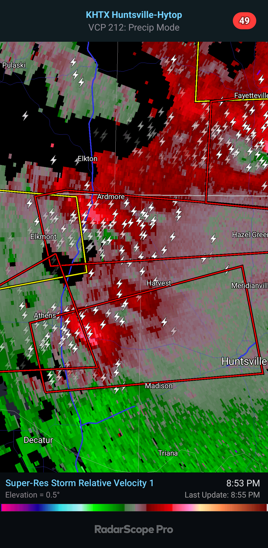
All right, as serious as this is . . . remember that the tornado coming East from Elkmont was confirmed earlier.
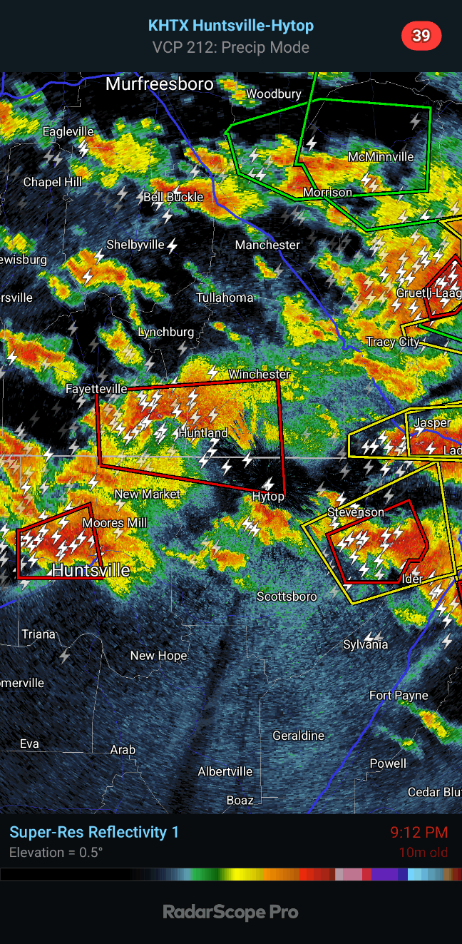
And let's take a look over in Jackson and Dekalb Counties because I didn't get to them in the last post.
But folks in Huntsville, at least the Northern part, need to go to shelter for this latest warning.
9 PM - We have two separate circulations that affect Jackson County, though the southern one is also clipping Dekalb County. The velocity is looking weak at the moment, but I would respect these warnings tonight. Reflectivity still looks like there's a tornado there. The northern warning clips Southeast Franklin County in TN. Just anywhere in these polygons, stay sheltered until sure the danger has passed. We've got a lot going on tonight.
9:05 - Tornado was confirmed just South of Ardmore. Remember that several of these storms are also producing golfball sized hail or larger. In the path of any of these, get into a small interior room on the lowest floor of a sturdy house. Stay away from windows and cover your body, esp your head. Do not stay in a mobile home if a tornado is coming.
9:07 - Another quick look at all our Tornado Warning polygons. Anywhere in these polygons, stay sheltered, even if it looks like the worst rotation is going somewhere else. It can be too hard to tell at night exactly where it is, plus multiple circulations can develop quickly in the same supercell thunderstorm. Play it safe!
9:10 - And since things are so incredibly busy right now, here is the wide view.
9:12 - Think this is a new one, includes Hytop, Huntland, and Flintville.
9:14 - It's kind of an extension of an earlier warning. This tornado has had a long track, and from the radar signature and the fact it was confirmed earlier, I think is capable of fairly significant damage.
And by the way,
WAFF-48 is seeing a wall cloud, maybe a funnel on their skycam.
9:18 - People in Huntsville need to stay in shelter, especially near and on the campus of UAH.
The rotation seems to be moving along University Drive. If you're driving in that area, stop and pull over to the nearest building and get inside, away from windows.
Broadcast media reports there were power flashes in Madison from this. Go ahead and consider this confirmed. It's night. They are hard to see. PLAY IT SAFE. Please.
People on the campus of Alabama A & M University need to be sheltered too, stay there.
Things have gotten so busy I totally missed the fact that the NWS Huntsville already said this was confirmed, a damaging tornado. But I've seen that now in the latest update so passing it along.
9:23 - We've got two other tornado warnings besides the one moving through Huntsville. Other locations in the path include that Bridge Street plaza and the Rocket Center, if you're close to there, be sheltered. Have to play these things safe.
9:26 - All right, now the NWS Huntsville reports a debris signature with the storm moving into Mid City/Huntsville.
9:30 - New post for new Huntsville tornado warning.
Tornado Warning
ALC083-089-090230-
/O.NEW.KHUN.TO.W.0021.240509T0152Z-240509T0230Z/
BULLETIN - EAS ACTIVATION REQUESTED
Tornado Warning
National Weather Service Huntsville AL
852 PM CDT Wed May 8 2024
The National Weather Service in Huntsville Alabama has issued a
* Tornado Warning for...
Northwestern Madison County in north central Alabama...
East central Limestone County in north central Alabama...
* Until 930 PM CDT.
* At 851 PM CDT, a severe thunderstorm capable of producing a
tornado was located near Tanner, or near Athens, moving east at 30
mph. Golf ball size hail has been confirmed with this storm.
HAZARD...Tornado and golf ball size hail.
SOURCE...Radar indicated rotation.
IMPACT...Flying debris will be dangerous to those caught without
shelter. Mobile homes will be damaged or destroyed.
Damage to roofs, windows, and vehicles will occur. Tree
damage is likely.
* This dangerous storm will be near...
Madison and Athens around 855 PM CDT.
Harvest around 900 PM CDT.
Northern Huntsville around 910 PM CDT.
Meridianville and Alabama A And M University around 925 PM CDT.
Other locations impacted by this tornadic thunderstorm include French
Mill and Capshaw.
PRECAUTIONARY/PREPAREDNESS ACTIONS...
TAKE COVER NOW! Move to a basement or an interior room on the lowest
floor of a sturdy building. Avoid windows. If you are outdoors, in a
mobile home, or in a vehicle, move to the closest substantial shelter
and protect yourself from flying debris.
Tornadoes are extremely difficult to see and confirm at night. Do not
wait to see or hear the tornado. TAKE COVER NOW!
&&
LAT...LON 3468 8697 3479 8700 3488 8659 3471 8655
TIME...MOT...LOC 0151Z 256DEG 25KT 3475 8691
TORNADO...RADAR INDICATED
MAX HAIL SIZE...1.75 IN
$$
70/DD


.png)


No comments:
Post a Comment