


The one for Northeast Lauderdale and Northwest Limestone was confirmed by spotters. It is going through rural areas, but everyone in the path of any of these polygons needs to take shelter. Going to have to put severe thunderstorm warnings on the back burner for the moment, but if you see you are under one of those, take cover too - small central room on lowest floor of a sturdy house, away from windows. And cover your head if you can, esp in tornado warnings.


.png)


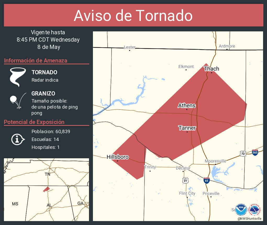
Tornado Warning
TNC103-090130-
/O.NEW.KHUN.TO.W.0012.240509T0057Z-240509T0130Z/
BULLETIN - EAS ACTIVATION REQUESTED
Tornado Warning
National Weather Service Huntsville AL
757 PM CDT Wed May 8 2024
The National Weather Service in Huntsville Alabama has issued a
* Tornado Warning for...
Southwestern Lincoln County in Middle Tennessee...
* Until 830 PM CDT.
* At 757 PM CDT, a tornado producing storm was located 7 miles west
of Ardmore, or 12 miles south of Pulaski, moving east at 35 mph.
HAZARD...Damaging tornado and ping pong ball size hail.
SOURCE...Radar confirmed tornado.
IMPACT...Flying debris will be dangerous to those caught without
shelter. Mobile homes will be damaged or destroyed.
Damage to roofs, windows, and vehicles will occur. Tree
damage is likely.
* This tornadic storm will be near...
Ardmore around 805 PM CDT.
Other locations impacted by this tornadic thunderstorm include
Skinem, Molino, Dellrose, Coldwater, Blanche, Belleview, Harms, Taft,
Camargo, and Cash Point.
PRECAUTIONARY/PREPAREDNESS ACTIONS...
To repeat, a tornado is on the ground. TAKE COVER NOW! Move to a
basement or an interior room on the lowest floor of a sturdy
building. Avoid windows. If you are outdoors, in a mobile home, or in
a vehicle, move to the closest substantial shelter and protect
yourself from flying debris.
Heavy rainfall may hide this tornado. Do not wait to see or hear the
tornado. TAKE COVER NOW!
&&
LAT...LON 3517 8652 3499 8651 3499 8684 3515 8683
TIME...MOT...LOC 0057Z 267DEG 32KT 3503 8696
TORNADO...OBSERVED
MAX HAIL SIZE...1.50 IN
$$
AMP
Severe Weather Statement
National Weather Service Huntsville AL
754 PM CDT Wed May 8 2024
ALC077-083-090115-
/O.CON.KHUN.TO.W.0009.000000T0000Z-240509T0115Z/
Limestone AL-Lauderdale AL-
754 PM CDT Wed May 8 2024
...A TORNADO WARNING REMAINS IN EFFECT UNTIL 815 PM CDT FOR
NORTHWESTERN LIMESTONE AND NORTHEASTERN LAUDERDALE COUNTIES...
At 753 PM CDT, a confirmed tornado was located near Rogersville, or
20 miles east of Florence, moving northeast at 20 mph.
HAZARD...Damaging tornado and half dollar size hail.
SOURCE...Weather spotters confirmed tornado.
IMPACT...Flying debris will be dangerous to those caught without
shelter. Mobile homes will be damaged or destroyed. Damage
to roofs, windows, and vehicles will occur. Tree damage is
likely.
This tornadic thunderstorm will remain over mainly rural areas of
northwestern Limestone and northeastern Lauderdale Counties,
including the following locations... Good Springs, Lester, Kingtown,
Oliver, Whitehead, Cairo, Mt Rozell, Leggtown, and Anderson.
PRECAUTIONARY/PREPAREDNESS ACTIONS...
To repeat, a tornado is on the ground. TAKE COVER NOW! Move to a
basement or an interior room on the lowest floor of a sturdy
building. Avoid windows. If you are outdoors, in a mobile home, or in
a vehicle, move to the closest substantial shelter and protect
yourself from flying debris.
Tornadoes are extremely difficult to see and confirm at night. Do not
wait to see or hear the tornado. TAKE COVER NOW!
&&
LAT...LON 3499 8700 3497 8697 3479 8725 3482 8732
3484 8737 3490 8743 3500 8735
TIME...MOT...LOC 0053Z 226DEG 17KT 3489 8731
TORNADO...OBSERVED
MAX HAIL SIZE...1.25 IN
$$
AMP
Tornado Warning
TNC103-127-090130-
/O.NEW.KHUN.TO.W.0011.240509T0052Z-240509T0130Z/
BULLETIN - EAS ACTIVATION REQUESTED
Tornado Warning
National Weather Service Huntsville AL
752 PM CDT Wed May 8 2024
The National Weather Service in Huntsville Alabama has issued a
* Tornado Warning for...
Central Moore County in Middle Tennessee...
Central Lincoln County in Middle Tennessee...
* Until 830 PM CDT.
* At 752 PM CDT, a severe thunderstorm capable of producing a tornado
was located 10 miles east of Pulaski, moving east at 35 mph.
HAZARD...Tornado and ping pong ball size hail.
SOURCE...Radar indicated rotation.
IMPACT...Flying debris will be dangerous to those caught without
shelter. Mobile homes will be damaged or destroyed.
Damage to roofs, windows, and vehicles will occur. Tree
damage is likely.
* This tornadic thunderstorm will remain over mainly rural areas of
central Moore and central Lincoln Counties, including the following
locations... Mulberry, Chestnut Ridge, Howell, Belleville, Mcburg,
Lois, Harms, Mimosa, Booneville, and Boonshill.
PRECAUTIONARY/PREPAREDNESS ACTIONS...
TAKE COVER NOW! Move to a basement or an interior room on the lowest
floor of a sturdy building. Avoid windows. If you are outdoors, in a
mobile home, or in a vehicle, move to the closest substantial shelter
and protect yourself from flying debris.
Heavy rainfall may hide this tornado. Do not wait to see or hear the
tornado. TAKE COVER NOW!
&&
LAT...LON 3535 8654 3536 8649 3532 8645 3532 8642
3535 8641 3535 8637 3514 8634 3512 8683
3526 8683 3525 8675 3531 8668 3533 8660
3536 8660 3537 8659
TIME...MOT...LOC 0052Z 265DEG 28KT 3524 8686
TORNADO...RADAR INDICATED
MAX HAIL SIZE...1.50 IN
$$
AMP
Tornado Warning
ALC049-071-090130-
/O.NEW.KHUN.TO.W.0010.240509T0052Z-240509T0130Z/
BULLETIN - EAS ACTIVATION REQUESTED
Tornado Warning
National Weather Service Huntsville AL
752 PM CDT Wed May 8 2024
The National Weather Service in Huntsville Alabama has issued a
* Tornado Warning for...
East central Jackson County in northeastern Alabama...
Northeastern DeKalb County in northeastern Alabama...
* Until 830 PM CDT.
* At 751 PM CDT, a severe thunderstorm capable of producing a tornado
was located over Henagar, or 10 miles north of Rainsville, moving
east at 20 mph. Emergency management reported a wall cloud.
HAZARD...Tornado and quarter size hail.
SOURCE...Radar indicated rotation.
IMPACT...Flying debris will be dangerous to those caught without
shelter. Mobile homes will be damaged or destroyed.
Damage to roofs, windows, and vehicles will occur. Tree
damage is likely.
* This dangerous storm will be near...
Henagar and Ider around 755 PM CDT.
Other locations impacted by this tornadic thunderstorm include
Sulpher Springs and Rosalie.
PRECAUTIONARY/PREPAREDNESS ACTIONS...
TAKE COVER NOW! Move to a basement or an interior room on the lowest
floor of a sturdy building. Avoid windows. If you are outdoors, in a
mobile home, or in a vehicle, move to the closest substantial shelter
and protect yourself from flying debris.
&&
LAT...LON 3458 8580 3465 8585 3486 8559 3463 8553
TIME...MOT...LOC 0051Z 250DEG 17KT 3463 8578
TORNADO...RADAR INDICATED
MAX HAIL SIZE...1.00 IN
$$
30
Severe Weather Statement
National Weather Service Nashville TN
800 PM CDT Wed May 8 2024
TNC003-055-117-090115-
/O.CON.KOHX.TO.W.0029.000000T0000Z-240509T0115Z/
Marshall TN-Giles TN-Bedford TN-
800 PM CDT Wed May 8 2024
...A TORNADO WARNING REMAINS IN EFFECT UNTIL 815 PM CDT FOR
SOUTHEASTERN MARSHALL...EAST CENTRAL GILES AND SOUTHWESTERN BEDFORD
COUNTIES...
At 759 PM CDT, a severe thunderstorm capable of producing a tornado
was located near Petersburg, or 8 miles south of Lewisburg, moving
east at 30 mph.
HAZARD...Tornado and quarter size hail.
SOURCE...Radar indicated rotation.
IMPACT...Flying debris will be dangerous to those caught without
shelter. Mobile homes will be damaged or destroyed. Damage
to roofs, windows, and vehicles will occur. Tree damage is
likely.
Locations impacted include...
Lewisburg, Cornersville, Belfast, and Frankewing.
PRECAUTIONARY/PREPAREDNESS ACTIONS...
TAKE COVER NOW! Move to a basement or an interior room on the lowest
floor of a sturdy building. Avoid windows. If you are outdoors, in a
mobile home, or in a vehicle, move to the closest substantial shelter
and protect yourself from flying debris.
&&
LAT...LON 3519 8687 3539 8687 3550 8651 3536 8650
3535 8653 3536 8654 3537 8659 3536 8660
3533 8660 3531 8668 3525 8675 3526 8683
3519 8683
TIME...MOT...LOC 0059Z 256DEG 28KT 3533 8673
TORNADO...RADAR INDICATED
MAX HAIL SIZE...1.00 IN
$$
Mueller
Severe Weather Statement
National Weather Service Nashville TN
758 PM CDT Wed May 8 2024
TNC055-090130-
/O.CON.KOHX.TO.W.0030.000000T0000Z-240509T0130Z/
Giles TN-
758 PM CDT Wed May 8 2024
...A TORNADO WARNING REMAINS IN EFFECT UNTIL 830 PM CDT FOR
SOUTHEASTERN GILES COUNTY...
At 758 PM CDT, a confirmed tornado was located 8 miles northwest of
Ardmore, or 9 miles southeast of Pulaski, moving east at 30 mph.
HAZARD...Damaging tornado and half dollar size hail.
SOURCE...Weather spotters confirmed tornado.
IMPACT...Flying debris will be dangerous to those caught without
shelter. Mobile homes will be damaged or destroyed. Damage
to roofs, windows, and vehicles will occur. Tree damage is
likely.
Locations impacted include...
Pulaski, Ardmore, Elkton, Prospect, and Frankewing.
This includes Interstate 65 between mile markers 1 and 13.
PRECAUTIONARY/PREPAREDNESS ACTIONS...
To repeat, a tornado is on the ground. TAKE COVER NOW! Move to a
basement or an interior room on the lowest floor of a sturdy
building. Avoid windows. If you are outdoors, in a mobile home, or in
a vehicle, move to the closest substantial shelter and protect
yourself from flying debris.
&&
LAT...LON 3500 8703 3515 8704 3520 8683 3500 8684
3499 8691
TIME...MOT...LOC 0058Z 259DEG 28KT 3508 8693
TORNADO...OBSERVED
MAX HAIL SIZE...1.25 IN
$$
Mueller
Severe Weather Statement
National Weather Service Nashville TN
752 PM CDT Wed May 8 2024
TNC003-015-031-177-090115-
/O.CON.KOHX.TO.W.0027.000000T0000Z-240509T0115Z/
Warren TN-Coffee TN-Bedford TN-Cannon TN-
752 PM CDT Wed May 8 2024
...A TORNADO WARNING REMAINS IN EFFECT UNTIL 815 PM CDT FOR
SOUTHWESTERN WARREN...COFFEE...NORTHEASTERN BEDFORD AND SOUTHWESTERN
CANNON COUNTIES...
At 752 PM CDT, a severe thunderstorm capable of producing a tornado
was located 7 miles east of Shelbyville, moving east at 30 mph.
HAZARD...Tornado and quarter size hail.
SOURCE...Radar indicated rotation.
IMPACT...Flying debris will be dangerous to those caught without
shelter. Mobile homes will be damaged or destroyed. Damage
to roofs, windows, and vehicles will occur. Tree damage is
likely.
This dangerous storm will be near...
Manchester around 805 PM CDT.
Other locations impacted by this tornadic thunderstorm include
Beechgrove, Normandy, Morrison, Bell Buckle, Wartrace, and
Summitville.
This includes Interstate 24 between mile markers 96 and 115.
PRECAUTIONARY/PREPAREDNESS ACTIONS...
TAKE COVER NOW! Move to a basement or an interior room on the lowest
floor of a sturdy building. Avoid windows. If you are outdoors, in a
mobile home, or in a vehicle, move to the closest substantial shelter
and protect yourself from flying debris.
&&
LAT...LON 3546 8643 3562 8641 3563 8637 3564 8638
3565 8635 3566 8634 3566 8631 3565 8630
3565 8628 3563 8625 3569 8625 3570 8622
3572 8595 3560 8586 3553 8587 3552 8588
3543 8589
TIME...MOT...LOC 0052Z 275DEG 26KT 3550 8631
TORNADO...RADAR INDICATED
MAX HAIL SIZE...1.00 IN
$$
10
Tornado Warning
TNC035-049-133-141-090115-
/O.NEW.KOHX.TO.W.0028.240509T0046Z-240509T0115Z/
BULLETIN - EAS ACTIVATION REQUESTED
Tornado Warning
National Weather Service Nashville TN
746 PM CDT Wed May 8 2024
The National Weather Service in Nashville has issued a
* Tornado Warning for...
Southeastern Overton County in Middle Tennessee...
North central Cumberland County in Middle Tennessee...
East central Putnam County in Middle Tennessee...
Southwestern Fentress County in Middle Tennessee...
* Until 815 PM CDT.
* At 745 PM CDT, a severe thunderstorm capable of producing a tornado
was located near Monterey, or 15 miles south of Livingston, moving
east at 45 mph.
HAZARD...Tornado.
SOURCE...Radar indicated rotation.
IMPACT...Flying debris will be dangerous to those caught without
shelter. Mobile homes will be damaged or destroyed.
Damage to roofs, windows, and vehicles will occur. Tree
damage is likely.
* This tornadic thunderstorm will remain over mainly rural areas of
southeastern Overton, north central Cumberland, east central Putnam
and southwestern Fentress Counties, including the following
locations... Crawford, Grimsley, and Clarkrange.
This includes Interstate 40 between mile markers 300 and 303.
PRECAUTIONARY/PREPAREDNESS ACTIONS...
TAKE COVER NOW! Move to a basement or an interior room on the lowest
floor of a sturdy building. Avoid windows. If you are outdoors, in a
mobile home, or in a vehicle, move to the closest substantial shelter
and protect yourself from flying debris.
&&
LAT...LON 3611 8529 3625 8533 3637 8483 3630 8483
3629 8484 3629 8487 3628 8488 3624 8488
3624 8489 3621 8491 3618 8490 3615 8491
3613 8487 3610 8484 3609 8482
TIME...MOT...LOC 0045Z 254DEG 40KT 3619 8523
TORNADO...RADAR INDICATED
MAX HAIL SIZE...<.75 IN
$$
Baggett


No comments:
Post a Comment