


If you would like some music to take your mind off the bad weather, tune in to Coyote J's Cemetery of Rock on WJLX 101.5 FM in Jasper. It sounds great on the iHeartRadio app. They have it on site and their own app too though.
Seriously I'll try to post updates here periodically but am trying to save my energy for when this squall line is that is forming gets closer to North Alabama.

10:02 PM - Just in case anybody needs it in Spanish...
10:09 - Severe thunderstorm warning includes Clarksville. So that's way North still. They are giving plenty of lead time since these storms have done a lot of damage earlier today and tonight. Even the wind gusts could get to 80 mph at times, and the hail could be golfball-sized or larger in some of the worse storms. That can be variable in a squall line. Sometimes you get more like 60 mph gusts and quarter-sized hail. But either way I'd respect the threat with any of these storms tonight - and get into a small interior room on the lowest floor of a sturdy house, away from windows if you go under a warning.

10:30 - Along with the squall line crossing the Kentucky/Tennessee state line, we also have to monitor those discrete supercells getting going in Arkansas. Got one between Georgetown and Augusta already looked like it is trying to produce a tornado.
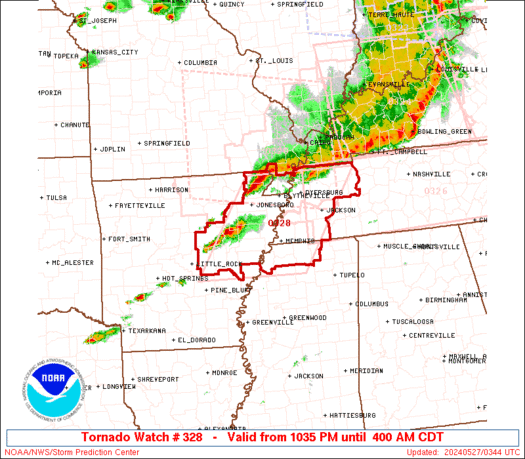

10:47 - And those supercell thunderstorms in Northeast Arkansas have just prompted a new Tornado Watch for mainly Western Tennessee but also including parts of Northern Mississippi. And they do note how with a setup like this, these supercells could produce a particularly damaging tornado somewhere. So I hate to be the bearer of bad news like that, but just a heads up. Definitely need to take any warnings seriously tonight. If you know anybody out that way, let 'em know. Maybe they can get to a storm shelter if they are in the path of something like that later. At the very least, I hope everybody tonight can get out of a mobile home and into a sturdy house for shelter. Mobile homes are just too dangerous when the tornado threat ramps up like tonight. If I couldn't get into a sturdier building, I'd honestly take my chances in a culvert or ditch that wasn't flooded if a confirmed tornado was coming at my trailer. Terrible scenario, but some people have survived tornadoes in ditches when their mobile homes were blown away. It even happened in April 2011, that horrific worst case type of day. And I believe the tornado I'm thinking about there was one of the F-5's which are super rare, they're so destructive.
And I probably should not be talking about them on a night like this. People are already on edge enough with all the drama from storm stories across the country lately.
Remember you need to get to the lowest floor of a sturdy house, in a small room like a bathroom or even a hallway if that's what you have. Try to put some walls between you and the outside, so usually that means the center of the house. But it could also just mean getting into the deepest part of your basement, far away from the door at the other end. One time I lived in a house with a closet in the far deepest part of the basement. So I didn't technically get to the center. But I put as much barrier between me (and my cat at the time . . . my brothers usually slept through it and didn't care . . . my ole man slept upstairs and definitely didn't care) and the storm outside as possible.
So that's where you need to be in your home if you get a tornado warning later.
Can't stay in a mobile home. And that lying in a ditch thing is a last resort. You try to get to a sturdy building or someone's house who will help you out.
But yeah, in a site-built home, just lowest floor (basement if you've got one, but ground floor is fine too), small room like a bathroom, closet, or hallway. Put some walls between you and the outside, much as you can. And that means you'll be well away from any windows.
Even in a basement, it can be a good idea to get up under something sturdy like a set of stairs, a table or desk, even a workbench. That way if debris falls, you have protection.
And from flying debris, even if you're sheltering on the ground floor in something like a bathroom, put on a helmet if you have one, to protect your head. Or if you don't have that, you've got a pillow or a blanket or two. Just shield your body in case things go flying around in the wind. Use what you have, and chances are, you'll be just fine, even if you were to get hit by a tornado. Or if you get hit by a really damaging thunderstorm with a lot of wind and hail.
Hope that helps . . .

11:17 PM - As of right now, it's looking more like 50 mph wind gusts and half-inch hail in diameter for much of Middle Tennessee as this Quasi-Linear-Convective-System, as someone from the Huntsville office just called it in a discussion (so I had to prove I can pronounce it) pushes into Middle Tennessee. Usually I just call it a squall line. Because I save tongue twisters for special occasions.
But seriously, any weakening trend with these storms is welcome news to my ears and eyes. Seen too much storm damage in other states already today. Let's just play this safe while this overnight threat lasts.
And look, it's a holiday weekend and we're going right into a holiday. Very few people are going to be up watching the weather.
So if you know somebody in the path of a tornado tonight, give them a call. Even if they cuss you out or whatever, I'd do it anyway. I'm sure all the soldiers this holiday is dedicated to, or probably most of them, would want people to live through a tornado.
And I do. I'm alive . . .
Or so it seems.
All joking aside, let's play it safe and take care of each other if and when this weather is serious tonight closer to home.

11:27 PM - Looks like those supercells from Arkansas are going to end up getting absorbed into the squall line over about the next hour. The squall line appears to be weakening at the moment as it moves into Tennessee. We'll still have to watch for supercells trying to form ahead of this squall line, just in case, even down in Alabama - could happen - the potential is there. I think it was the HRRR showing that earlier, but I'm seen so much weather data today and pictures and video that it kind of jumbles all together in my head. I remember that model showing something really wacky at one point.
But the idea of supercells ahead of the line could actually happen.
And more likely, we have to watch storms within the line in case they become severe. The atmosphere certainly favors it. But for right now, happy to say, the line as a whole appears to be in a weakening phase as it moves down into Northern and Middle Tennessee.

11:32 - Not looking so great in Northwest Tennessee, a large chunk there under a Severe Thunderstorm Warning now for 60 mph wind gusts, some small hail and lightning in there too. And a possible tornado coming out of Northeast Arkansas in the general direction of Dyersburg if it sustains across the state line. And it is a supercell, so probably will. Tornado Warning in effect there.
11:46 - Coyote Calhoun has played two Genesis songs from when Peter Gabriel was their lead singer. I tend to forget he was in that band before Phil Collins. But I have a brother who is a huge fan of his solo work. And he used to argue with one of my friends over who was better in Genesis. So I should remember. I missed the title of the first one that the DJ said he didn't like, but I did like. Now he's playing one called "The Fountain of Salmacis." And it also sounds great.
Back to the weather at top of hour. Just an interlude to focus on something not deadly serious, like great music. Since sane people are sleeping now anyway.

Midnight going into Memorial Day Morning - Going to have to watch these storms in Northwest Alabama, and some have been trying to get going in Tennessee too, ahead of the squall line. Any of these could quickly become supercells and produce some thunderstorm damage or even a tornado. Gotta' keep an eye on it given our atmosphere tonight.
Got a report of a tree down in the road in Sumner County, Tn. Blocking both lanes at Highway 52/Old 52 and power out in North Portland. That report was relayed by ham radio.

12:04 AM - Got to watch these developing storms in Northwest Alabama. The stuff further into Tennessee is mostly going through a weakening phase, much of it actually staying under severe limits for now. Though on the West side, some has been severe, including a wind damage report, don't always get those so quick at night.
12:24 - Mainly going to focus on North Alabama or bordering counties of Tennessee, but keep seeing sporadic reports of trees down and power outages in Northern Tennessee. So this squall line is worth taking seriously as well as any storms that form ahead of it. If they can erode the capping inversion tonight, they could quickly become supercells and would pose a tornado threat as well as a threat for large hail and damaging winds.

12:30 - These storms around the Shoals bear watching, as they could intensify rapidly and become severe in this environment.
SEL6
URGENT - IMMEDIATE BROADCAST REQUESTED
Tornado Watch Number 326
NWS Storm Prediction Center Norman OK
940 PM CDT Sun May 26 2024
The NWS Storm Prediction Center has issued a
* Tornado Watch for portions of
Much of Tennessee
* Effective this Sunday night and Monday morning from 940 PM
until 500 AM CDT.
* Primary threats include...
A few tornadoes likely with a couple intense tornadoes possible
Widespread damaging winds and isolated significant gusts to 80
mph likely
Scattered large hail and isolated very large hail events to 2
inches in diameter possible
SUMMARY...A severe squall line will likely move into Tennessee
tonight. Embedded supercells and line-embedded mesovortices will
potentially be capable of tornadoes and severe gusts. The
environment will potentially support the risk for strong tornadoes,
in addition to swaths of severe gusts.
The tornado watch area is approximately along and 55 statute miles
north and south of a line from 25 miles west northwest of Jackson TN
to 10 miles east northeast of Knoxville TN. For a complete depiction
of the watch see the associated watch outline update (WOUS64 KWNS
WOU6).
PRECAUTIONARY/PREPAREDNESS ACTIONS...
REMEMBER...A Tornado Watch means conditions are favorable for
tornadoes and severe thunderstorms in and close to the watch
area. Persons in these areas should be on the lookout for
threatening weather conditions and listen for later statements
and possible warnings.
&&
OTHER WATCH INFORMATION...CONTINUE...WW 320...WW 321...WW
322...WW 323...WW 324...WW 325...
AVIATION...Tornadoes and a few severe thunderstorms with hail
surface and aloft to 2 inches. Extreme turbulence and surface wind
gusts to 70 knots. A few cumulonimbi with maximum tops to 500. Mean
storm motion vector 30035.
...Smith
WATCH COUNTY NOTIFICATION FOR WATCHES 320/326
NATIONAL WEATHER SERVICE MEMPHIS TN
943 PM CDT SUN MAY 26 2024
ARC021-031-055-093-111-MOC069-155-TNC005-017-033-045-053-079-095-
097-131-183-270400-
/O.CON.KMEG.TO.A.0320.000000T0000Z-240527T0400Z/
TORNADO WATCH 320 REMAINS VALID UNTIL 11 PM CDT THIS EVENING FOR
THE FOLLOWING AREAS
IN ARKANSAS THIS WATCH INCLUDES 5 COUNTIES
IN EAST ARKANSAS
CLAY CRAIGHEAD GREENE
MISSISSIPPI POINSETT
IN MISSOURI THIS WATCH INCLUDES 2 COUNTIES
IN SOUTHEAST MISSOURI
DUNKLIN PEMISCOT
IN TENNESSEE THIS WATCH INCLUDES 10 COUNTIES
IN WEST TENNESSEE
BENTON CARROLL CROCKETT
DYER GIBSON HENRY
LAKE LAUDERDALE OBION
WEAKLEY
THIS INCLUDES THE CITIES OF ALAMO, BLYTHEVILLE, CAMDEN,
CARUTHERSVILLE, CORNING, DRESDEN, DYERSBURG, HARRISBURG,
HUMBOLDT, HUNTINGDON, JONESBORO, KENNETT, MARTIN, MILAN,
PARAGOULD, PARIS, PIGGOTT, RIPLEY TN, TIPTONVILLE,
AND UNION CITY.
$$
TORNADO WATCH OUTLINE UPDATE FOR WT 326
NWS STORM PREDICTION CENTER NORMAN OK
940 PM CDT SUN MAY 26 2024
TORNADO WATCH 326 IS IN EFFECT UNTIL 500 AM CDT FOR THE
FOLLOWING LOCATIONS
TNC001-003-007-009-011-013-015-021-023-025-027-031-035-037-039-
041-043-049-051-055-057-061-063-065-067-069-071-073-075-077-081-
083-085-087-089-093-099-101-103-105-107-109-111-113-115-117-119-
121-123-125-127-129-133-135-137-139-141-143-145-147-149-151-153-
155-159-161-165-167-169-173-175-177-181-185-187-189-271000-
/O.NEW.KWNS.TO.A.0326.240527T0240Z-240527T1000Z/
TN
. TENNESSEE COUNTIES INCLUDED ARE
ANDERSON BEDFORD BLEDSOE
BLOUNT BRADLEY CAMPBELL
CANNON CHEATHAM CHESTER
CLAIBORNE CLAY COFFEE
CUMBERLAND DAVIDSON DECATUR
DE KALB DICKSON FENTRESS
FRANKLIN GILES GRAINGER
GRUNDY HAMBLEN HAMILTON
HANCOCK HARDEMAN HARDIN
HAWKINS HAYWOOD HENDERSON
HICKMAN HOUSTON HUMPHREYS
JACKSON JEFFERSON KNOX
LAWRENCE LEWIS LINCOLN
LOUDON MACON MADISON
MARION MARSHALL MAURY
MCMINN MCNAIRY MEIGS
MONROE MONTGOMERY MOORE
MORGAN OVERTON PERRY
PICKETT POLK PUTNAM
RHEA ROANE ROBERTSON
RUTHERFORD SCOTT SEQUATCHIE
SEVIER SMITH STEWART
SUMNER TIPTON TROUSDALE
UNION VAN BUREN WARREN
WAYNE WHITE WILLIAMSON
WILSON
$$
ATTN...WFO...MRX...OHX...MEG...HUN...


No comments:
Post a Comment